
The Batu Pahat District is a district in the state of Johor, Malaysia. It lies southeast of Muar, southwest of Kluang, northwest of Pontian, south of Segamat and Tangkak District. The capital of the district is Bandar Penggaram.

The Segamat District or simply Segamat is a district in the Malaysian state of Johor. Segamat is also the name of the district's primary town. Segamat district is one of the three landlocked districts in Johor, the other being Kluang and Kulai.
Federal Route 5 is one of the three north–south oriented backbone federal roads running along the west coast of Peninsular Malaysia, Malaysia. The 655.85 kilometres (408 mi) federal highway runs from Jelapang, Perak in the north to Skudai, Johor in the south.
Federal Route 50, or Jalan Batu Pahat–Kluang–Mersing, is a main federal road in Johor, Malaysia. The road connects Batu Pahat in the west to Jemaluang in the east. It is also a main route to North-South Expressway Southern Route via Ayer Hitam Interchange.

Parit Sulong Bridge is a bridge in Parit Sulong, Batu Pahat District, Johor, Malaysia. The original bridge was the site of a famous battle during World War II.

Parit Raja is a town in Batu Pahat District, Johor, Malaysia. The main population of this town and its surrounding areas has been resided by Malay with Javanese descent, besides the Chinese population.
High School Batu Pahat (HSBP) (Malay: Sekolah Menengah Kebangsaan Tinggi Batu Pahat (SMKTBP); abbreviated as Sekolah Tinggi Batu Pahat (STBP) also known as Sekolah Menengah Kebangsaan Tinggi Batu Pahat formally) is a secondary school for boys located in the town of Batu Pahat in the state of Johor, Malaysia. It was known as Government English School previously, but was changed to High School Batu Pahat after the independence of Malaysia.

The Batu Pahat River is a river originating from Sungai Simpang Kiri and Sungai Simpang Kanan near Tongkang Pechah, and flows through Batu Pahat and until it reaches the mouth of the river in Pantai Minyak Beku, a seaside village lying on the west coast of Johor, Malaysia.

Minyak Beku is a mukim in Batu Pahat District, Johor, Malaysia.
Mount Ma'okil is a mountain at the border of Batu Pahat District and Muar District in Johor, Malaysia.
Gunung is the Malay and Indonesian word for mountain —it is regularly used in volcano and mountain names throughout Southeast Asia.

Sri Gading or Seri Gading is a mukim and parliamentary constituency in Batu Pahat District, Johor, Malaysia, located along Jalan Batu Pahat-Kluang. It lies south-east of Batu Pahat town, north-west of Ayer Hitam and west of Yong Peng. It is also a name of one of 14 parishes in Johor.
The Segamat River is a river which flows within the District of Segamat, Johor, Malaysia which also flows through Segamat town center. The source of the river is at Gunung Besar which is located within Endau Rompin National Park and its confluence is at the Muar River.

Taman Flora Utama is a township in Bandar Penggaram, Batu Pahat, Johor, Malaysia. It was constructed in 2005. Taman Flora Utama is located beside Jalan Tan Siew Hoe. The new township is developing rapidly. This township is mainly for shopping, leisure and commercial activities.

Batu Pahat, also sometimes known as Bandar Penggaram or by its initials as BP, is a town and capital of Batu Pahat District, Johor, Malaysia. It lies south-east of Muar, south-west of Kluang, north-west of Pontian and south of Segamat. The town area is located inside Simpang Kanan parishes.

Batu Pahat Municipal Council is a local authority which administrates West Batu Pahat District in Johor, Malaysia. This agency is under Johor state government. MPBP are responsible for public health and sanitation, waste removal and management, town planning, environmental protection and building control, social and economic development and general maintenance functions of urban infrastructure. The MPBP main headquarters is located at Jalan Pejabat, Bandar Penggaram, Batu Pahat.
Segenting is a small town in Minyak Beku, Batu Pahat District, Johor, Malaysia. It is about 8 km away from Bandar Penggaram, Batu Pahat, capital of Batu Pahat district.

Lubok Mukim is a mukim in Batu Pahat District, Johor, Malaysia. This district would be surrounded by the mukims of Bagan (east) and Simpang Kiri (north) and the Muar district (west).

Sultanah Nora Ismail Hospital or more commonly referred as Batu Pahat Hospital is a government-funded multi-specialty rural general hospital located in Batu Pahat, Johor, Malaysia.
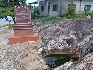
The Batu Pahat Well is a historic well at the village of Minyak Beku, Batu Pahat District, Johor, Malaysia. It was allegedly built during the 15th century by fleeing Siamese soldiers from the Malacca Sultanate, who chiselled the rocks around it in search of water. It was said that the name of the town of Batu Pahat was originated from the well's name. It is currently one of the most popular tourist destinations of the area.