
Kuantan is a city and the state capital of Pahang, Malaysia. It is located near the mouth of the Kuantan River. Kuantan is the 14th largest city in Malaysia based on a 2020 population of 548,014 and the largest city on the East Coast of Peninsular Malaysia.

Kukup is a small fishing village in Pontian District, Johor, Malaysia. It is famous for its open-air seafood restaurants built on stilts over the water. Regularly scheduled ferries connect Kukup with Tanjung Balai in Indonesia.
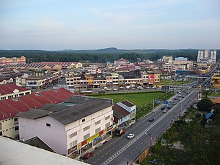
Kota Tinggi is a town and capital of Kota Tinggi District, Johor, Malaysia.

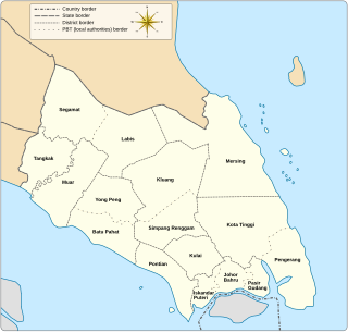
Pontian District is a district located in southwest part of the Malaysian state of Johor. It borders Batu Pahat and Kluang Districts to the north and Kulai and Johor Bahru Districts to the east.
Federal Route 5 is one of the three north–south oriented backbone federal roads running along the west coast of Peninsular Malaysia, Malaysia. The 655.85 kilometres (408 mi) federal highway runs from Jelapang, Perak in the north to Skudai, Johor in the south.
Sedili or Tanjung Sedili is a coastal region in Kota Tinggi District, Johor, Malaysia. At the eastern end of this region is a bay known as Teluk Mahkota.
Pengerang is a municipality in Kota Tinggi District, in the Malaysian state of Johor. It was established in 2017. It is home to the Pengerang Integrated Petroleum Complex (PIPC), the largest petrochemical complex in Malaysia, and one of the major petrochemical hubs in the world.
Teluk Mahkota is a bay and tourism attraction in Sedili, Kota Tinggi District, Johor, Malaysia.
Teluk Kumbar is a suburb of George Town in the Malaysian state of Penang. It is located about 17.8 km (11.1 mi) south of the city centre, at the southern coast of Penang Island between Bayan Lepas to the east and Gertak Sanggul to the west.

Mukim Kota Batu is a mukim in Brunei-Muara District, Brunei. The population was 12,935 in 2016. The mukim is home to some of the country's museums and historical sites, in particular in Kota Batu.
Jalan Sedili Kechil, Federal Route, is a federal road in Johor, Malaysia. It is also a main route to Teluk Mahkota and Tanjung Balau. The Kilometre Zero of the Federal Route 213 starts at Tanjung Sedili.
The Mantanani Islands are a group of three islands off the north-west coast of the state of Sabah, Malaysia, opposite the town of Kota Belud, in northern Borneo. The largest island is Mantanani Besar; the other two are Mantanani Kecil and Lungisan. It is a popular site for recreational diving and is known for its dugongs.

Kota Tinggi District is a district in the Malaysian state of Johor. It is the largest district in the state with an area of 3,488.7 square kilometres (1,347.0 sq mi). The population was 222,382 in 2020. The principal town is Kota Tinggi.
Haji Mohd Lazim Bridge or Tanjung Sedili Bridge is a river bridge in Sedili, Johor, Malaysia. The bridges crosses Sedili Besar River. A road bridge spans the river near its mouth close to the village of Tanjung Sedili. It spans 600 metres across the river and links the coastal regions to the north and south of the river. Its construction was completed in around 2006 and it opened in 2009. It was named after Ustaz Haji Mohd Lazim bin Saim, an Islamic religious school teacher of the Madrasah Arabiah Kluang.

The Pitas District is an administrative district in the Malaysian state of Sabah, part of the Kudat Division which includes the districts of Kota Marudu, Kudat and Pitas. The capital of the district is in Pitas Town.
Ayer Limau is a state constituency in Malacca, Malaysia, that has been represented in the Malacca State Legislative Assembly. The state constituency was first contested in 2004 and is mandated to return a single Assemblyman to the Malacca State Legislative Assembly under the first-past-the-post voting system. Since 2021, the State Assemblyman for Ayer Limau is Hameed Mytheen Kunju Basheer from United Malays National Organisation (UMNO) which is part of the state's ruling coalition, Barisan Nasional (BN).
The following is an alphabetical list of articles related to Selangor.
Pangkor is a state constituency in Perak, Malaysia, that has been represented in the Perak State Legislative Assembly.
Kampong Sungai Besar or commonly known as Sungai Besar, is a village in the east of Brunei-Muara District, Brunei, near the mouth of the Brunei River with the Brunei Bay. The population was 2,039 in 2016.

