
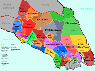
The Batu Pahat District is a district in the state of Johor, Malaysia. It lies southeast of Muar, southwest of Kluang, northwest of Pontian, south of Segamat and Tangkak District. The capital of the district is Bandar Penggaram.

The Segamat District or simply Segamat is a district in the Malaysian state of Johor. Segamat is also the name of the district's primary town. Segamat district is one of the three landlocked districts in Johor, the other being Kluang and Kulai.

Pontian District is a district located in southwest part of the Malaysian state of Johor. It borders Batu Pahat and Kluang Districts to the north and Kulai and Johor Bahru Districts to the east.
Federal Route 5 is one of the three north–south oriented backbone federal roads running along the west coast of Peninsular Malaysia, Malaysia. The 655.85 kilometres (408 mi) federal highway runs from Jelapang, Perak in the north to Skudai, Johor in the south.
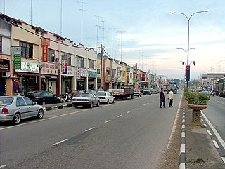
Yong Peng is a town in Mukim Tanjung Semberong, Batu Pahat District, Johor, Malaysia. It has an area of 1911.6 hectares with an estimated population of 29,046.

The Perlis River is a river in Perlis, Malaysia.

The Kuala Muda District is a district in Kedah, Malaysia. Sungai Petani is the administrative center of the district. Kuala Muda district is in close proximity to the border of Kedah and Penang. Apart from Sungai Petani, other major towns in the district include Tikam Batu, Padang Tembusu, Sungai Lalang, Bedong, Bukit Selambau, Sidam, Gurun, Semeling, Merbok, Kota Kuala Muda and Tanjung Dawai. The Mount Jerai is shared with the neighbouring district of Yan while the Muda River is shares the bordering state of Penang. The iconic Jambatan Merdeka connect both Tikam Batu with Bumbung Lima in Penang. Kuala Muda is the second largest and most populous district in Kedah, and it is also the site of some of the earliest civilization site in the country.

The Tangkak District is a district in western Johor, Malaysia, bordering Muar District to the south, Segamat District to the northeast, and Jasin District, Malacca to the west. The district also shares an 11 kilometre border with Tampin District, Negeri Sembilan to the northwest. The district capital and largest settlement is the town of Tangkak. Other towns include Sagil, Sungai Mati and Tanjung Agas.

Floods in Malaysia are one of the most regular natural disasters affecting the country, which occurs nearly every year especially during the monsoon season. The coasts of peninsular Malaysia are the most prone to flooding especially during the northeast monsoon season from October to March.

Sri Gading or Seri Gading is a mukim and parliamentary constituency in Batu Pahat District, Johor, Malaysia, located along Jalan Batu Pahat-Kluang. It lies south-east of Batu Pahat town, north-west of Ayer Hitam and west of Yong Peng. It is also a name of one of 14 parishes in Johor.

Mohd. Ali bin Mohd. Rustam is a Malaysian politician who has served as the 7th Yang di-Pertua Negeri of Melaka since June 2020. He served as the 9th Chief Minister of Melaka from December 1999 to May 2013, Deputy Minister of Health from November 1996 to December 1999, Deputy Minister of Transport from May 1995 to November 1996, Member of Parliament (MP) for Batu Berendam from April 1995 to November 1999, Member of the Malacca State Legislative Assembly (MLA) for Bukit Batu from March 2004 to May 2013, for Paya Rumput from November 1999 to March 2004, for Sungai Udang from October 1990 to April 1995 and for Ayer Molek from August 1986 to October 1990. He was a member of the United Malays National Organisation (UMNO), a component party of the Barisan Nasional (BN) coalition.

The Muar District is a district in Johor, Malaysia. Muar is located at the mouth of the Muar River, on the coast of the Straits of Malacca. The Muar District covers 1,354 km2 (523 sq mi), with a population of 233,779 (2010).
Batu Pahat (BP) also sometimes known as Bandar Penggaram is a town and capital of Batu Pahat District, Johor, Malaysia. It lies south-east of Muar, south-west of Kluang, north-west of Pontian and south of Segamat. The town area is located inside Simpang Kanan parishes.

Batu Pahat Municipal Council is a local authority which administrates West Batu Pahat District in Johor, Malaysia. This agency is under Johor state government. MPBP are responsible for public health and sanitation, waste removal and management, town planning, environmental protection and building control, social and economic development and general maintenance functions of urban infrastructure. The MPBP main headquarters is located at Jalan Pejabat, Bandar Penggaram, Batu Pahat.

Idris bin Haron is a Malaysian politician who served as the 10th Chief Minister of Melaka from May 2013 to May 2018, Member of the Melaka State Executive Council (EXCO) from March 2020 to his resignation in October 2021, Member of the Melaka State Legislative Assembly (MLA) for Sungai Udang from May 2013 to November 2021, Deputy Minister of Higher Education from March 2008 to April 2009 and Member of Parliament (MP) for Tangga Batu from March 2004 to May 2013. Internationally, he is President of the World Assembly of Youth. He is a member of the People's Justice Party (PKR), a component party of the Pakatan Harapan (PH) coalition. He was also member of the United Malays National Organisation (UMNO), a component party of Barisan Nasional (BN) coalition.

Lubok Mukim is a mukim in Batu Pahat District, Johor, Malaysia. This district would be surrounded by the mukims of Bagan (east) and Simpang Kiri (north) and the Muar district (west).

Sultanah Nora Ismail Hospital or more commonly referred as Batu Pahat Hospital is a government-funded multi-specialty rural general hospital located in Batu Pahat, Johor, Malaysia.
Batu Pahat is a federal constituency in Batu Pahat District, Johor, Malaysia, that has been represented in the Dewan Rakyat since 1955.
Mukim Kampung Bahru or Kampong Bahru is a mukim located in Batu Pahat District in Johor, Malaysia. Batu Pahat District was divided into 14 mukims, each of which encompasses several villages. The population was 11,997 in 2010. The majority ethics of the population in the Kampung Bahru is Malay (9,286).
Mukim Sungai Punggor or Sungai Punggur is a mukim located in Batu Pahat District in Johor, Malaysia. Batu Pahat District was divided into 14 mukims, each of which encompasses several villages. The population was 10,417 in 2010. The majority ethics of the population in the Sungai Punggor is Malay (8,887). The nearby towns is Bandar Rengit (east) and Bandar Senggarang (west).

