Related Research Articles

The Batu Pahat District is a district in the state of Johor, Malaysia. It lies southeast of Muar, southwest of Kluang, northwest of Pontian, south of Segamat and Tangkak District. The capital of the district is Bandar Penggaram.

The Segamat District or simply Segamat is a district in the Malaysian state of Johor. Segamat is also the name of the district's primary town. Segamat district is one of the three landlocked districts in Johor, the other being Kluang and Kulai.

Mersing is a town, mukim and the capital of Mersing District, Johor, Malaysia.
Federal Route 3 is a main federal road running along the east coast of Peninsula Malaysia. The 739 kilometres (459 mi) federal highway connects Rantau Panjang in Kelantan until Johor Bahru in Johor. The entire FT3 highway is gazetted as a part of the Asian Highway Network route 18.

The Muar River is a river which flows through the states of Negeri Sembilan and Johor in Malaysia. Its drainage basin encompasses the states aforementioned, as well as Pahang and Malacca.
Tun Razak Highway, Federal Route 12(Lebuhraya Tun Razak), also known as Segamat-Kuantan Highway(Lebuhraya Segamat-Kuantan), Asian Highway Route 142, is a 146.8 kilometres (91 mi) federal highway running from the town of Segamat, Johor to Gambang before proceeding another 38 kilometres (24 mi) via Federal Route 2 to Gambang near Kuantan, Pahang. This two-lane federal road is named in honor of Tun Abdul Razak, Malaysia's second Prime Minister who was also known as Malaysia's Father of Development. The highway is part of the Asian Highway Network of route 142.

The Sultan Ismail Bridge is a bridge in Muar town across the Muar River in Johor, Malaysia. It was the first bridge built across a river that connects Bandar Maharani, Muar to Tanjung Agas which is now named as part of Tangkak district. The bridge replaced old ferry services in the 1960s. The bridge was originally a toll bridge making the second toll bridge in Malaysia after Sultan Yahya Petra Bridge in Kelantan.
The Buloh Kasap Bridge is a historical bridge in Malaysia, made famous during World War II. It is located on Federal Route 1 in the town of Buloh Kasap, Segamat District, Johor, Malaysia. The bridge is built across the Muar River (Sungai Muar) which flows pass Buloh Kasap.
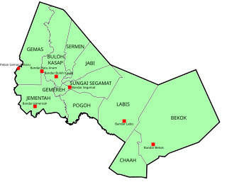
Buloh Kasap is a mukim in Segamat District, Johor, Malaysia which is located about 10 km (6 mi) from Segamat town center via Federal Route 1. Because of its location near Segamat and the rapid development of Taman Yayasan in the area, Buloh Kasap is one of two satellite towns of Segamat after Bandar Segamat Baru/Bandar IOI. Tun Razak Highway is located roughly about 4 km (2 mi) from Buloh Kasap.

Batu Kikir is a small town in Jempol District, Negeri Sembilan, Malaysia. Situated along the Tampin-Karak highway, Batu Kikir is located in between Bahau and Kuala Pilah.
Gemas Baru is a small town in Segamat District, Johor, Malaysia. The town is located about 1 km from the Johor-Negeri Sembilan border. The original town centre of Gemas is located just within the Negeri Sembilan state side of the border and also shared the same postal code 73400.

The Kuala Muda District is a district in Kedah, Malaysia. Sungai Petani is the administrative center of the district. Kuala Muda district is in close proximity to the border of Kedah and Penang. Apart from Sungai Petani, other major towns in the district include Tikam Batu, Padang Tembusu, Sungai Lalang, Bedong, Bukit Selambau, Sidam, Gurun, Semeling, Merbok, Kota Kuala Muda and Tanjung Dawai. The Mount Jerai is shared with the neighbouring district of Yan while the Muda River is shares the bordering state of Penang. The iconic Jambatan Merdeka connect both Tikam Batu with Bumbung Lima in Penang. Kuala Muda is the second largest and most populous district in Kedah, and it is also the site of some of the earliest civilization site in the country.

Floods in Malaysia are one of the most regular natural disasters affecting the country, which occurs nearly every year especially during the monsoon season. The coasts of peninsular Malaysia are the most prone to flooding especially during the northeast monsoon season from October to March.

Batu Anam is a town in the northern part of Segamat District, Johor, Malaysia. The town is the home to the 4th Royal Artillery Regiment of the Malaysian Armed Forces and the Royal Malaysian Police Training Centre (PULAPOL). It is about halfway between downtown Segamat and Gemas, Negeri Sembilan.
Segamat Inner Ring Road, Johor State Routes J152, J216 and J217 is a 4-lane single carriageway municipal ring road system in Segamat, Johor, Malaysia. The ring road consists of Jalan Pemuda, Jalan Hassan, Segamat Second Bridge, Jalan Hassan Abdullah, Jalan Pee Kang Hai and Jalan Chia Chin Koon.

The Muar District is a district in Johor, Malaysia. Muar is located at the mouth of the Muar River, on the coast of the Straits of Malacca. The Muar District covers 1,354 km2 (523 sq mi), with a population of 233,779 (2010).
Batu Pahat (BP) is a town and capital of Batu Pahat District, Johor, Malaysia. It lies south-east of Muar, south-west of Kluang, north-west of Pontian and south of Segamat. The town area is located inside Simpang Kanan parishes.
Raja Temenggung of Muar was a noble title used to refer to the family of Dato' Pasir Raja and his descendants, which ruled the Muar fief, which was a part of the Johor Empire from the middle of the seventeenth century onwards.

Segamat is a town and district capital located in Segamat District, Johor, Malaysia.

Pasir Mas District is a district (jajahan) in Kelantan, Malaysia. The district covers an area of 614.15 square kilometers and is bordered by the districts of Tumpat District to the north, Tanah Merah District to the south, Kota Bharu District to the east, and the Thai district of Su-ngai Kolok to the west.
References
- YM Ungku Mohd. Zaman bin Tahir (1996). Segamat: Sejarah dan Mitosnya. Al-Kafilah Enterprise.
2°30′44.8″N102°49′29.3″E / 2.512444°N 102.824806°E
| | This Johor location article is a stub. You can help Wikipedia by expanding it. |
| | This article related to a river in Malaysia is a stub. You can help Wikipedia by expanding it. |