
The Johor Strait is an international strait in Southeast Asia, between Singapore and Peninsular Malaysia.

Tanjung Piai is a cape in Pontian District, Johor, Malaysia. It is the southernmost point of Peninsular Malaysia and thus the most southern point of mainland Eurasia. The skyline of Singapore is visible across the Johor Strait from the point. It features seafood restaurants, perched on wooden jetties that are surrounded by a rugged and rarefied coastline of unspoiled mangrove forests.
The state of Johor in Malaysia is noted for its national parks and forest reserves which preserve virgin rainforests known for its biodiversity and endangered species of animals. Mangrove swamps and coral reefs are also protected within these parks.

Phang Nga Bay is a 400 km2 (150 sq mi) bay in the Andaman Sea between the island of Phuket and the mainland of the Kra Isthmus of southern Thailand. Since 1981, an extensive section of the bay has been protected as the Ao Phang Nga National Park. The park is in Phang Nga Province, at 8°17′N98°36′E.

Menabe Antimena is a protected area in Menabe region of western Madagascar. It belongs to the municipalities of Tsimafana, Beroboka, Bemanonga, Belon'i Tsiribihina, and Tsaraotana.

The Kulai District is a district in the state of Johor, Malaysia. Its district capital is Kulai Town. It covers Kulai Town, Ayer Bemban, Bandar Putra Kulai, Bukit Batu, Indahpura, Bandar Baru Kangkar Pulai, Kelapa Sawit, Saleng, Sedenak, Seelong, Senai, and Sengkang. Kulai is also within Iskandar Malaysia economic zone.

Kukup Island is an island in Pontian District, Johor, Malaysia.

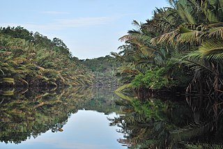
Pulau Merambong, formerly known as Pulo Ular, is an uninhabited island on the Straits of Johor. The island is dominated by mangrove swamp. It is located just 1 kilometre off the coast from Tuas, Singapore. Administratively, it is placed under the Pontian District, Johor, Malaysia.

Bao BolongWetland Reserve is a protected area in The Gambia. Established in 1996, it covers 296.5 square kilometres.

Deforestation in Malaysia is a major environmental issue in the country. British colonial deforestation efforts began in 1880 and were rapidly driven by commercial rubber and palm oil cultivation.

The environment of Malaysia is the biotas and geologies that constitute the natural environment of Malaysia. Malaysia's ecology is megadiverse, with a biodiverse range of flora and fauna found in various ecoregions throughout the country. Tropical rainforests encompass between 59% and 70% of Malaysia's total land area, of which 11.6% is pristine. Malaysia has the world's fifth largest mangrove area, which totals over a half a million hectares.
The Berbak National Park in Sumatra island, Jambi province of Indonesia, forms part of the largest undisturbed swamp forest in southeastern Asia, and the peat swamp forest with the greatest number of palm species. Protected since 1935 under Dutch colonial law and later declared a national park, it has been also recognised as a wetland of international importance.

Mangrove ecosystems represent natural capital capable of producing a wide range of goods and services for coastal environments and communities and society as a whole. Some of these outputs, such as timber, are freely exchanged in formal markets. Value is determined in these markets through exchange and quantified in terms of price. Mangroves are important for aquatic life and home for many species of fish.

The mangroves of the Straits of Malacca are found along the coast of Thailand, Malaysia, Singapore and northern Sumatra. These tropical mangrove forests are highly diverse, and are important wetlands with high conservation values. There are two Ramsar sites along the Strait of Malacca: Pulau Kukup and Tanjung Piai.

The Hunter Estuary Wetlands comprise a group of associated wetlands at and near the mouth of the Hunter River in the city of Newcastle, New South Wales, Australia. The wetlands are part of Hunter Wetlands National Park. 30 km2 of the wetlands have been recognised as being of international importance by designation under the Ramsar Convention. It was listed on 21 February 1984 as Ramsar site 287. A larger area of the wetlands has been identified by BirdLife International as an Important Bird Area (IBA). The wetlands are recognised as the most important area in New South Wales for waders, or shorebirds.

Orang Seletar are one of the 18 Orang Asli ethnic groups in Malaysia. They are classified under the Proto-Malay people group, which forms the three major people group of the Orang Asli. The Orang Seletar are also considered as part of the Orang Laut, natives of the Straits of Johor; separating Singapore from Peninsula Malaysia.
The Lebam River is a river and surrounding wetlands located near Desaru, in the eastern part of the state of Johor, Malaysia. The Johor National Parks Agency wants to promote the wetlands as a stopover site according to the Ramsar Convention and for the tourism industry. It is the largest tributary of the Johor River. Visitors may take a boat to explore the wildlife, especially the fireflies living in the mangrove apple trees.

Forest City is an integrated residential development and private town located in Iskandar Puteri, Johor, Malaysia. It is located in the southwestern part of Johor Bahru District, the second largest district in Malaysia by population. First announced in 2006 as a twenty-year investment project mostly financed by a consortium of mainland Chinese private real estate developers, pitched under the Belt and Road Initiative.
Los Petenes Biosphere Reserve is a biosphere reserve in Mexico. It is located on the western Yucatán Peninsula in the state of Campeche. The reserve is home to extensive mangrove wetlands, and rich in birds and other wildlife.

