Teggiano

Last updated
Teggiano
Rianu (Neapolitan)
Città di Teggiano
Teggiano, Vallo di Diano, Italia (panorama).jpg
Panoramic View
Teggiano-Stemma.jpg
Location of Teggiano
Teggiano
Italy provincial location map 2016.svg
Red pog.svg
Teggiano
Location of Teggiano in Italy
Italy Campania location map.svg
Red pog.svg
Teggiano
Teggiano (Campania)
Coordinates: 40°23′N15°32′E / 40.383°N 15.533°E / 40.383; 15.533
Country Italy
Region Campania
Province Province of Salerno (SA)
Frazioni Facofano, Macchiaroli, Pantano, Piedimonte, Prato Perillo, San Marco
Government
  MayorMichele Di Candia (since June 06,2016)
Area
[1]
  Total61.87 km2 (23.89 sq mi)
Elevation
637 m (2,090 ft)
Population
 (31 December 2017) [2]
  Total7,794
  Density130/km2 (330/sq mi)
Demonym Teggianesi
Time zone UTC+1 (CET)
  Summer (DST) UTC+2 (CEST)
Postal code
84039
Dialing code 0975
Patron saint Saint Conus
Saint day3 June
Website Official website
Castle of Teggiano. Castello Teggiano.jpg
Castle of Teggiano.

Teggiano (Teggianese : Rianu), formerly Diano, is a town and comune (municipality) in the province of Salerno, Campania, Italy. It is situated on an isolated eminence above the upper part of the valley to which it gives the name of Vallo di Diano. [3]

Contents

Among the historic centers of the province, Teggiano is certainly one that has best preserved its ancient appearance of the fortress and it is this aspect which is shown to those who reach the old town. The appearance of a Roman oppidum, still now remembered by the well preserved plan of the Cardo and of the Decumanus, was renewed in the Norman period and in the age of Frederick II of Hohenstaufen.

History

Tegianum was built by Lucanians early in the 4th century BC, and later was a municipal town of Lucania. There was Gracchan colonization in the 2nd century BCE, and a larger colonization program under Nero. [3]

During the Middle Ages Diano had a predominant role in the history of the Vallo di Diano. In Norman times, the Sanseverino family, counts of Marsico and later princes of Salerno, took over the fief of Diano, which was composed of the hamlets of Sassano, Monte San Giacomo, San Rufo, San Pietro al Tanagro and Sant'Arsenio. Teggiano was ruled by the Sanseverino for over three centuries (1239–1556). They chose the castle as a stronghold in which they could take shelter during emergencies. At that time Diano was surrounded by high walls with 25 guard towers and four gates. In 1497, under Antonello Sanseverino of Salerno, the city resisted the siege undertaken by Frederick IV of Naples [3] for 8 months. Following a new rebellion, led this time by Ferrante, last Prince of Salerno, in 1552 the Sanseverino family was expelled from the kingdom. Teggiano became a fief of other noble families including the Gomez da Silva, the Grimaldi, the Caracciolo, the Villani, the Colonna, the Calà and Schipani.

St. Antuono church. S Antuono.jpg
St. Antuono church.

In 1564, after the Council of Trent, Bishop Paolo Varallo instituted in Diano one of the first seminaries in Italy, completed in 1601. On July 17, 1586 Pope Sixtus V gave the right to establish the residence in Diano, in the actual see, to Bishop Lelio Morello, giving to Diano Episcopalian prerogatives and raised in the meanwhile the church of S. Maria Maggiore to the honor of Cathedral. The action of the Counter-Reformation and the presence of high offices brought in the later centuries a radical remaking of the Romano-Gothic churches in Baroque style.

Two major earthquakes concerned Teggiano's territory: the Neapolitan earthquake that occurred on December 16, 1857 (estimated of magnitude 6.9 on the Richter Scale), and the Irpininan earthquake on November 23, 1980 (measuring 6.89 on the Richter Scale).

Main sights

Ruins of the ancient city can be traced at the foot of the hill; a Roman bridge is also present. Other landmarks are:

Twin towns

See also

Related Research Articles

<span class="mw-page-title-main">Conversano</span> Comune in Apulia, Italy

Conversano is an ancient town and comune in the Metropolitan City of Bari, Apulia, south-eastern Italy. It is 30 kilometres (19 mi) southeast of Bari and 7 kilometres (4 mi) from the Adriatic coast, at 219 metres (719 ft) above sea level.

<span class="mw-page-title-main">Agropoli</span> Comune in Campania, Italy

Agropoli is a town and comune located in the Cilento area of the province of Salerno, Campania, Italy. It is situated at the start of the Cilentan Coast, on the Tyrrhenian Sea.

<span class="mw-page-title-main">Sant'Angelo dei Lombardi</span> Comune in Campania, Italy

Sant'Angelo dei Lombardi is a town and comune in the province of Avellino in the Campania region of southern Italy. It has been a historical spot of significance in mezzogiorno history.

Salandra is a town and comune in the province of Matera, in the Southern Italian region of Basilicata.

Stigliano is a town and comune in the province of Matera, in the Basilicata region of southern Italy.

<span class="mw-page-title-main">Atena Lucana</span> Comune in Campania, Italy

Atena Lucana is a town and comune in the province of Salerno in the Campania region of south-western Italy.

<span class="mw-page-title-main">Gioi</span> Comune in Campania, Italy

Gioi is a town and comune in the province of Salerno in the Campania region of south-western Italy. As of 2011, its population was 1,339.

<span class="mw-page-title-main">Monte San Giacomo</span> Comune in Campania, Italy

Monte San Giacomo is a town and comune in the province of Salerno in the Campania region of south-western Italy.

<span class="mw-page-title-main">Sala Consilina</span> Comune in Campania, Italy

Sala Consilina is a town and comune in the province of Salerno in the Campania region of southwestern Italy. With 12,635 inhabitants it is the most populated town of Vallo di Diano.

<span class="mw-page-title-main">San Pietro al Tanagro</span> Comune in Campania, Italy

San Pietro al Tanagro is a village and comune in the province of Salerno in the Campania region of south-west Italy.

<span class="mw-page-title-main">San Rufo</span> Comune in Campania, Italy

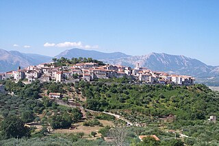
San Rufo is a village and comune in the province of Salerno, in the Campania region of southern Italy located in the Vallo di Diano. San Rufo extends over 31 square kilometres, much of which is mountainous or hilly terrain. With defence in mind, the old town was built at over 600 meters above sea level. Another reason for the choice of location was the marshy nature of the wide Vallo di Diano plain, which sits at an average 450 metres above sea level.

<span class="mw-page-title-main">Sant'Arsenio</span> Comune in Campania, Italy

Sant'Arsenio is a town and comune in the Province of Salerno in the Campania region of south-western Italy, located about 180 km southeast of Naples and about 76 km southeast of Salerno. As of 30 June 2006, it had a population of 2,714 and an area of 20 km2.

<span class="mw-page-title-main">Sassano</span> Comune in Campania, Italy

Sassano is a town and comune in the province of Salerno in the Campania region of south-western Italy.

<span class="mw-page-title-main">Diano Castello</span> Municipality in Liguria, Italy

Diano Castello is a comune (municipality) in the Province of Imperia in the Italian region Liguria, located about 90 kilometres (56 mi) southwest of Genoa and about 5 kilometres (3 mi) northeast of Imperia. As of 31 December 2004, it had a population of 2,061 and an area of 6.0 square kilometres (2.3 sq mi).

<span class="mw-page-title-main">Padula</span> Comune in Campania, Italy

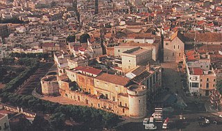
Padula is a comune in the province of Salerno in the Campania region of south-western Italy. It is the home of the Carthusian monastery Certosa di San Lorenzo, sometimes referred to as the Certosa di Padula. As of 2011 its population was of 5,279.

<span class="mw-page-title-main">Gesù Nuovo</span> Church in Campania, Italy

Gesù Nuovo is the name of a church and a square in Naples, Italy. They are located just outside the western boundary of the historic center of the city. To the southeast of the spire, one can see a block away the Fountain of Monteoliveto and the piazza of the church of Sant'Anna dei Lombardi. The square is a result of the expansion of the city to the west beginning in the early 16th century under the rule of Spanish viceroy Pedro Alvarez de Toledo. The square of Gesù Nuovo contains three prominent landmarks:

Diano may refer to:

<span class="mw-page-title-main">Parco Nazionale del Cilento, Vallo di Diano e Alburni</span>

Cilento, Vallo di Diano and Alburni National Park is an Italian national park in the Province of Salerno, in Campania in southern Italy. It includes much of the Cilento, the Vallo di Diano and the Monti Alburni. It was founded in 1991, and was formerly known as the Parco Nazionale del Cilento e Vallo di Diano.

<span class="mw-page-title-main">Vallo di Diano</span> Valley in Salerno, Italy

The Vallo di Diano is an Italian valley of the south-eastern side of Campania, in the province of Salerno.

The Cilentan dialect is a Neapolitan dialect spoken in the area of Cilento, located in the southern part of the Province of Salerno, Campania, Italy.

References

  1. "Superficie di Comuni Province e Regioni italiane al 9 ottobre 2011". Italian National Institute of Statistics. Retrieved 16 March 2019.
  2. "Popolazione Residente al 1° Gennaio 2018". Italian National Institute of Statistics. Retrieved 16 March 2019.
  3. 1 2 3 Wikisource-logo.svg One or more of the preceding sentences incorporates text from a publication now in the public domain :  Ashby, Thomas (1911). "Teggiano". In Chisholm, Hugh (ed.). Encyclopædia Britannica . Vol. 26 (11th ed.). Cambridge University Press. p. 505.

Sources