Balinese is an Austronesian language spoken on the Indonesian island of Bali, as well as Northern Nusa Penida, Western Lombok, Southern Sumatra, and Sulawesi. Most Balinese speakers also use Indonesian. The 2000 national census recorded 3.3 million people speakers of Balinese, however the Bali Cultural Agency estimated in 2011 that the number of people still using the Balinese language in their daily lives is under 1 million. The language has been classified as "not endangered" by Glottolog.

The Gili Islands are an archipelago of three small islands or Gili island triplets — Gili Trawangan, Gili Meno and Gili Air — just off the northwest coast of Lombok, Indonesia. The local name of these three islands is Gili Indah which means "small beautiful islands". They were previously administered under Lombok Barat Regency along with Senggigi until 2010 when the Gili islands came under the jurisdiction of the new North Lombok Regency ; together they form an administrative village (desa) within the Pemenang District (kecamatan) of North Lombok Regency.

Padangbai is a small coastal town in the Karangasem Regency, in south-eastern Bali, Indonesia. It serves as a ferry port for travel to Lembar on Lombok, The Gilis and other Lesser Sunda Islands.

Nusa Dua is a resort area built in the 1970s in the southern part of Bali, Indonesia. Known as an enclave of large five-star resorts, it covers 350 hectares of land and encloses more than 20 resorts. It is located 22 kilometers from Denpasar, the provincial capital of Bali, and is administered as part of Benoa subdistrict (kelurahan) in South Kuta, Badung Regency. Nusa Dua means two islands, because there are two islands in the bay of the Indonesia Tourism Development Corporation (ITDC) area. On the southern side lies Peninsula Island, and on the northern side lies Nusa Dharma Island, which is smaller but shadier, and which contains the Pura/Temple Nusa Dharma.

Bangli Regency is the one and only landlocked regency (kabupaten) of Bali, Indonesia.

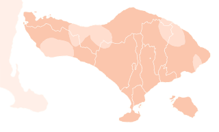
Buleleng, officially Buleleng Regency, is a regency of Bali Province, Indonesia. It stretches along the north side of the island of Bali from the Bali Strait in the west almost to the eastern end of the island. It has an area of 1,365.88 km2 and a population of 624,125 at the 2010 census and 791,910 at the 2020 census; the official estimate as of mid-2022 was 825,141. Its regency seat is in the town of Singaraja.

West Bali National Park is a national park located in Buleleng Regency and Jembrana Regency, on the west point of Bali, Indonesia. The park covers around 190 square kilometres (73 sq mi), some 82% of which is on land and the remainder at sea. This is approximately 3% of Bali's total land area.

Sanur is a coastal stretch of beach east of Denpasar in southeast Bali, which has grown into a little town in its own right. A 5.1 km (3.2 mi) area of Sanur's coastline, from Matahari Terbit Beach to Mertasari Beach, was reclaimed in 2008.

Candi Dasa, or often Candidasa is a seaside town on the eastern cost of Bali that rests on the edge of a fresh water lagoon, named Candi Dasa Lagoon. The town is centred around Jalan Raya Candida, where a number of hotels, restaurants, and shops line the main road. It is popular tourist stop, attracting divers and those looking for a more sedate alternative to the busy, nightclub filled Kuta area or the large, manicured resorts at Nusa Dua.

Lovina Beach is a beach on the northwestern side of the island of Bali, Indonesia.

The Bali Aga, Baliaga, or Bali Mula are the indigenous people of Bali. Linguistically they are an Austronesian people. Bali Aga people are predominantly located in the eastern part of the island, in Bangli especially the mountains Kintamani, East Buleleng, West Buleleng and East Karangasem, but they can also be found in north-western and central regions. The term Bali Aga or Bali Pégunungan is regarded as an insult with an additional meaning of "the mountain people that are fools"; therefore, they prefer the term Bali Mula instead.

Sumberkima Village is a small settlement, located in west Buleleng Regency, in the north-west corner of Bali island, a Province of the Indonesian archipelago.

Nusa Lembongan is an island located southeast of Bali, Indonesia. It is part of a group of three islands that make up the Nusa Penida district, of which it is the most famous of the three islands of Nusa Penida, Nusa Lembongan, and Nusa Ceningan - known together as the "Nusa Islands". This island group, in turn, is part of the Lesser Sunda Islands.
Gerokgak is a village and a district (kecamatan) in the Buleleng Regency, on the north-west coast of Bali, Indonesia.

Banjar is a district (kecamatan) in the regency of Buleleng in northern Bali, Indonesia.

Wakatobi National Park is a marine national park in Southeast Sulawesi, Indonesia. It was established in 2002. The name of Wakatobi is a portmanteau of the four main Tukangbesi Islands: Wangi-wangi, Kaledupa, Tomia, and Binongko. Since 2005 the park is listed as a tentative World Heritage Site.

North Halmahera Regency is a regency of North Maluku Province, Indonesia. It was declared a separate Regency on 25 February 2003, formed from part of the former North Maluku Regency. The capital town of the regency lies at the port of Tobelo. The Regency, which was considerably reduced by the separation of Morotai Island to form a separate regency on 26 November 2008, now covers an area of 3,404.27 square kilometres (1,314.40 sq mi) and had a population of 161,847 people at the 2010 Census, 179,783 at the 2015 Intermediate Census. and 197,640 at the 2020 Census. The official estimate as at mid 2023 was 203,213. The principal settlements are Tobelo, Kao and Galela. The area is noted for its white beaches and coral reefs.

Amed is a village on the east coast in Abang District, Karangasem Regency, Bali, Indonesia. In the wake of heavy tourism development, actors in the tourism industry use the village's name to designate a 14-km stretch of coast that includes several other villages, namely from west to east: Amed, Jemeluk, Bunutan, Lipah, Lehan, Selang, Banyuning, Aas and Kusambi. A more correct geographical name would be the north coast of the Seraya peninsula, or North Seraya.
The Balinese copperplate inscription or Sembiran inscription is a collection of ten copper plate inscriptions, which were found in the village of Sembiran, Tejakula district, Buleleng Regency, on the northern part of Bali island. All inscription plates have a date, which is between 922 and 1181 CE, so they include more than 200 years. Sembiran AI is dated 844 saka, Sembiran B is dated 873 saka, Sembiran A II is dated 897 saka, Sembiran A III is dated 938 saka, Sembiran A IV is dated 987 saka, and Sembiran C is dated 1103 saka. Some of the oldest inscriptions are written in Old Balinese, while some of the later ones are written in Old Javanese.


