Tejas, Las Piedras, Puerto Rico

Last updated
Tejas
Barrio
Tejas, Las Piedras, Puerto Rico locator map.png
Location of Tejas within the municipality of Las Piedras shown in red
Caribbean location map.svg
Red pog.svg
Tejas
Location of Puerto Rico
Coordinates: 18°09′06″N65°52′30″W / 18.15162°N 65.874967°W / 18.15162; -65.874967 [1]
Commonwealth Flag of Puerto Rico.svg  Puerto Rico
Municipality LasPiedrasFlag.svg Las Piedras
Area
[1]
  Total6.02 sq mi (15.6 km2)
  Land6.02 sq mi (15.6 km2)
  Water0 sq mi (0 km2)
Elevation
[2]
653 ft (199 m)
Population
 (2010)
  Total9,488
  Density1,576.1/sq mi (608.5/km2)
 Source: 2010 Census
Time zone UTC−4 (AST)
ZIP Code
00771

Tejas is a barrio in the municipality of Las Piedras, Puerto Rico. Its population in 2010 was 9,488. [3] [4] [5]

Contents

History

Tejas was in Spain's gazetteers [6] until Puerto Rico was ceded by Spain in the aftermath of the Spanish–American War under the terms of the Treaty of Paris of 1898 and became an unincorporated territory of the United States. In 1899, the United States Department of War conducted a census of Puerto Rico finding that the population of Tejas barrio was 948. At that time, the municipality was called Piedras and Tejas barrio was called Tejas Alto. [7]

Historical population
CensusPop.Note
1900 1,639
1910 2,04124.5%
1920 2,1485.2%
1930 2,2595.2%
1940 2,72720.7%
1950 2,8374.0%
1960 2,711−4.4%
1980 5,927
1990 7,89833.3%
2000 8,98513.8%
2010 9,4885.6%
U.S. Decennial Census
1899 (shown as 1900) [8] 1910-1930 [9]
1930-1950 [10] 1980-2000 [11] 2010 [12]

See also

Related Research Articles

<span class="mw-page-title-main">Oriente, San Juan, Puerto Rico</span> Barrio of Puerto Rico

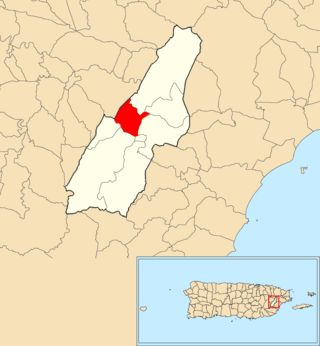
Oriente is one of the 18 barrios of the municipality of San Juan, Puerto Rico. It is composed of 3 subbarrios: Borinquen, López Sicardó, and San José. Before 1951, it was a barrio of the former municipality of Rio Piedras. In 2010, it had a population of 31,374. It is surrounded by the barrios of Sabana Llana Norte to the east, Sabana Llana Sur to the south, Hato Rey Central and Hato Rey Norte to the west, and Santurce barrio and the San Jose Lagoon to the north.

<span class="mw-page-title-main">Hato Tejas, Bayamón, Puerto Rico</span> Barrio of Puerto Rico

Hato Tejas is a barrio in the municipality of Bayamón, Puerto Rico. Its population in 2010 was 41,851.

<span class="mw-page-title-main">Nuevo, Bayamón, Puerto Rico</span> Barrio of Puerto Rico

Nuevo is a barrio in the municipality of Bayamón, Puerto Rico. Its population in 2010 was 2,965.

<span class="mw-page-title-main">Turabo, Caguas, Puerto Rico</span> Barrio of Puerto Rico

Turabo or Villa Turabo is a barrio in the municipality of Caguas, Puerto Rico. Its population in 2010 was 15,739.

<span class="mw-page-title-main">Tejas, Humacao, Puerto Rico</span> Barrio of Puerto Rico

Tejas is a barrio in the municipality of Humacao, Puerto Rico. Its population in 2010 was 6,821.

<span class="mw-page-title-main">Tejas, Yabucoa, Puerto Rico</span> Barrio of Puerto Rico

Tejas is a barrio in the municipality of Yabucoa, Puerto Rico. Its population in 2010 was 3,044.

<span class="mw-page-title-main">El Río, Las Piedras, Puerto Rico</span> Barrio of Puerto Rico

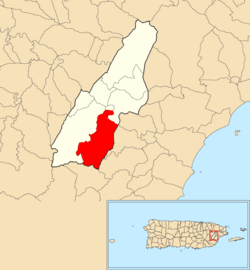
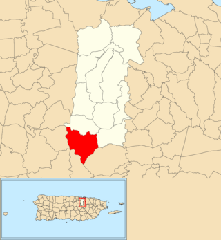
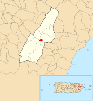
El Río is a barrio in the municipality of Las Piedras, Puerto Rico. Its population in 2010 was 5,096.

<span class="mw-page-title-main">Montones</span> Barrio of Las Piedras, Puerto Rico

Montones is a barrio in the municipality of Las Piedras, Puerto Rico. Its population in 2010 was 9,332.

<span class="mw-page-title-main">Abra Honda, Camuy, Puerto Rico</span> Barrio of Puerto Rico

Abra Honda is a barrio in the municipality of Camuy, Puerto Rico. Its population in 2010 was 1,943.

<span class="mw-page-title-main">Piedra Gorda, Camuy, Puerto Rico</span> Barrio of Puerto Rico

Piedra Gorda is a barrio in the municipality of Camuy, Puerto Rico. Its population in 2010 was 1,846.

<span class="mw-page-title-main">Collores, Las Piedras, Puerto Rico</span> Barrio of Puerto Rico

Collores is a barrio in the municipality of Las Piedras, Puerto Rico. Its population in 2010 was 4,710.

<span class="mw-page-title-main">Boquerón, Las Piedras, Puerto Rico</span> Barrio of Puerto Rico

Boquerón is a barrio in the municipality of Las Piedras, Puerto Rico. Its population in 2010 was 1,824.

<span class="mw-page-title-main">Quebrada Arenas, Las Piedras, Puerto Rico</span> Barrio of Puerto Rico

Quebrada Arenas is a barrio in the municipality of Las Piedras, Puerto Rico. Its population in 2010 was 4,225.

<span class="mw-page-title-main">Las Piedras barrio-pueblo</span> Historical and administrative center (seat) of Las Piedras, Puerto Rico

Las Piedras barrio-pueblo is a barrio and the administrative center (seat) of Las Piedras, a municipality of Puerto Rico. Its population in 2010 was 1,500.

<span class="mw-page-title-main">Piedras Blancas, San Sebastián, Puerto Rico</span> Barrio of Puerto Rico

Piedras Blancas is a barrio in the municipality of San Sebastián, Puerto Rico. Its population in 2010 was 2,563.

<span class="mw-page-title-main">Piedras Blancas, Aguada, Puerto Rico</span> Barrio of Puerto Rico

Piedras Blancas is a barrio in the municipality of Aguada, Puerto Rico. Its population in 2010 was 4,635.

<span class="mw-page-title-main">Guamaní</span> Barrio of Guayama, Puerto Rico

Guamaní is a barrio in the municipality of Guayama, Puerto Rico. Its population in 2010 was 1,455.

<span class="mw-page-title-main">Matón Abajo, Cayey, Puerto Rico</span> Barrio of Puerto Rico

Matón Abajo is a barrio in the municipality of Cayey, Puerto Rico. Its population in 2010 was 926.

<span class="mw-page-title-main">Piedras, Cayey, Puerto Rico</span> Barrio of Puerto Rico

Piedras is a barrio in the municipality of Cayey, Puerto Rico. Its population in 2010 was 195.

<span class="mw-page-title-main">Ala de la Piedra</span> Barrio of Orocovis, Puerto Rico

Ala de la Piedra is a barrio in the municipality of Orocovis, Puerto Rico. Its population in 2010 was 419.

References

  1. 1 2 "US Gazetteer 2019". US Census. US Government.
  2. U.S. Geological Survey Geographic Names Information System: Tejas barrio
  3. Picó, Rafael; Buitrago de Santiago, Zayda; Berrios, Hector H. Nueva geografía de Puerto Rico: física, económica, y social, por Rafael Picó. Con la colaboración de Zayda Buitrago de Santiago y Héctor H. Berrios. San Juan Editorial Universitaria, Universidad de Puerto Rico,1969.
  4. Gwillim Law (20 May 2015). Administrative Subdivisions of Countries: A Comprehensive World Reference, 1900 through 1998. McFarland. p. 300. ISBN   978-1-4766-0447-3 . Retrieved 25 December 2018.
  5. Puerto Rico: 2010 Population and Housing Unit Counts.pdf (PDF). U.S. Dept. of Commerce, Economics and Statistics Administration, U.S. Census Bureau. 2010.
  6. "Anuario del comercio, de la industria, de la magistratura y de la administración. 1881". Biblioteca Nacional de España (in Spanish). p. 1614. Retrieved 4 April 2023.
  7. Joseph Prentiss Sanger; Henry Gannett; Walter Francis Willcox (1900). Informe sobre el censo de Puerto Rico, 1899, United States. War Dept. Porto Rico Census Office (in Spanish). Imprenta del gobierno. p.  163.
  8. "Report of the Census of Porto Rico 1899". War Department Office Director Census of Porto Rico. Archived from the original on July 16, 2017. Retrieved September 21, 2017.
  9. "Table 3-Population of Municipalities: 1930 1920 and 1910" (PDF). United States Census Bureau. Archived (PDF) from the original on August 17, 2017. Retrieved September 21, 2017.
  10. "Table 4-Area and Population of Municipalities Urban and Rural: 1930 to 1950" (PDF). United States Census Bureau. Archived (PDF) from the original on August 30, 2015. Retrieved September 21, 2014.
  11. "Table 2 Population and Housing Units: 1960 to 2000" (PDF). United States Census Bureau. Archived (PDF) from the original on July 24, 2017. Retrieved September 21, 2017.
  12. Puerto Rico: 2010 Population and Housing Unit Counts.pdf (PDF). U.S. Dept. of Commerce Economics and Statistics Administration U.S. Census Bureau. 2010. Archived (PDF) from the original on 2017-02-20. Retrieved 2019-08-02.