| ||||
|---|---|---|---|---|
| Route information | ||||
| Maintained by TDOT | ||||
| Length | 24.59 mi (39.57 km) | |||
| Major junctions | ||||
| West end | ||||
| East end | ||||
| Highway system | ||||
| ||||

State Route 142 (SR 142) is a 24.59 mile long east-west state highway in West Tennessee.
| ||||
|---|---|---|---|---|
| Route information | ||||
| Maintained by TDOT | ||||
| Length | 24.59 mi (39.57 km) | |||
| Major junctions | ||||
| West end | ||||
| East end | ||||
| Highway system | ||||
| ||||
State Route 142 (SR 142) is a 24.59 mile long east-west state highway in West Tennessee.
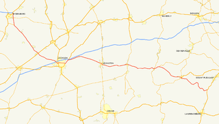
SR 142 begins in McNairy County in Selmer at an intersection with US 45/SR 5 south of downtown. It goes east to leave Selmer and pass through first farmland, then wooded areas, to pass through Stantonville, where it has a short concurrency with SR 224. The highway then turns southeast to pass through West Shiloh, where it has an intersection with SR 117, before crossing into Hardin County. [1] SR 142 immediately enters Hurley and comes to an intersection and becomes concurrent with SR 22. They go south along the western edge of Shiloh National Military Park to arrive at Shiloh, where SR 142 splits off and goes south through wooded and hilly areas to pass by Childers Hill to enter Southside and come to an intersection with SR 57. It goes west along SR 57 for a short distance before turning south again through wooded areas to come to an end at the Mississippi state line, where it continues as Alcorn County Road 100 to Mississippi Highway 350 (MS 350), which is less than half a mile away, and the town of Farmington. [2] The entire route of SR 142 is a two-lane highway. [3]
This section contains a table that is missing mileposts for one or more junctions. |
| County | Location | mi | km | Destinations | Notes |
|---|---|---|---|---|---|
| McNairy | Selmer | 0.0 | 0.0 | Western terminus | |
| Stantonville | Western end of SR 224 concurrency | ||||
| Eastern end of SR 224 concurrency | |||||
| West Shiloh | Southern terminus of SR 117 | ||||
| Hardin | Hurley | Western end of SR 22 concurrency | |||
| Shiloh | Eastern end of SR 22 concurrency | ||||
| Southside | Western end of wrong-way SR 57 concurrency; provides access to Pickwick Landing Dam and Pickwick Landing State Park | ||||
| Eastern end of wrong-way SR 57 concurrency | |||||
| | 24.59 | 39.57 | Mississippi state line; eastern terminus | ||
1.000 mi = 1.609 km; 1.000 km = 0.621 mi
| |||||

U.S. Route 45 is a major north-south United States highway and a border-to-border route, from Lake Superior to the Gulf of Mexico. A sign at the highway's northern terminus notes the total distance as 1,297 miles (2,087 km).
U.S. Route 72 (US 72) is an east–west United States highway that travels for 317.811 miles (511.467 km) from southwestern Tennessee, North Mississippi, North Alabama, and southeastern Tennessee. The highway's western terminus is in Memphis, Tennessee and its eastern terminus is in Chattanooga. It is the only U.S. Highway to begin and end in the same state, yet pass through other states in between. Prior to the U.S. Highway system signage being posted in 1926, the entire route was part of the Lee Highway.
U.S. Route 45W is a 62.33-mile-long (100.31 km) United States Numbered Highway in West Tennessee, connecting Jackson with South Fulton via Humboldt, Trenton, Rutherford, and Union City. For the majority of its length, it runs concurrently with unsigned State Route 5.
State Route 22 is a 172.8-mile long (278.1 km) south-to-north state highway in the western part of Tennessee, United States. It begins at the Mississippi state line in McNairy County, where the roadway continues as Mississippi Highway 2. It ends at the Kentucky state line in Lake County, when it crosses into the Kentucky Bend, a detached portion of Fulton County, Kentucky. The monument for the 1862 Battle of Island Number Ten in the American Civil War is located on SR 22, about 3 mi (4.8 km) north of Tiptonville.

State Route 5 is a 120-mile-long (190 km) north–south state highway in the western part of the U.S. state of Tennessee. Except for the section northwest of Union City, it is entirely concurrent with U.S. Route 45 and US 45W.

State Route 99 is a long east–west highway in Middle Tennessee. The route travels through large sections of rural areas and for most of the length is a secondary highway. The route begins near Waynesboro and ends in Bradyville after logging 126.7 mi (203.9 km) and passing through six counties.
State Route 20 (SR 20) is a 143.04-mile (230.20 km) long east–west primary state highway that begins in Dyersburg and ending near Summertown. SR 20 is unsigned and concurrent with U.S. Route 412 (US 412) for its entire length, except for a short section between Hohenwald and Summertown. Along its route, SR 20 traverses parts of both Middle Tennessee and West Tennessee.
State Route 15 is a west–east route from Memphis to Monteagle. For much of its route it has an unsigned concurrency with U.S. Route 64. SR 15 does travel through the southern part of all 3 Grand Divisions of the state: West Tennessee, Middle Tennessee, and East Tennessee.
State Route 57 is an east–west highway that runs from Memphis to the Mississippi state line near Pickwick Dam and Pickwick Landing State Park. Except for in Shelby County and western Fayette County, SR 57 is a two lane road generally with a 55 mph (89 km/h) speed limit. The majority of the road follows the path of the Memphis and Charleston Railroad.
State Route 76 (SR 76) is a state highway in Tennessee, traversing the state in a northeast-southwest axis from east of Memphis to north of Nashville. SR 76 is unique in that it actually changes its cardinal directions in Clarksville at the junction with US 41A and US 41A Bypass.
In Tennessee, U.S. Route 412 stretches for 181.93 miles (292.79 km) through the farmland of West Tennessee and the hills of Middle Tennessee.
State Route 125 is a north–south state route in southern West Tennessee. It begins north of Silerton at SR 100 and ends at the Tennessee–Mississippi state line, where it continues as Mississippi Highway 15.
U.S. Route 45 in Tennessee extends from the Mississippi state line to the Kentucky state line in West Tennessee, passing through the cities of Selmer, Henderson, Jackson, and South Fulton. Between Three Way and South Fulton, the highway is split into US 45W and US 45E.
Mississippi Highway 149 is a state highway in Mississippi. The route designation is given to five former segments of U.S. Route 49, and one former section of US 49W, within the state that have been bypassed. The sections run through Wiggins, Mount Olive, between Magee and Sanatorium, between Mendenhall and Braxton, between Yazoo City and Silver City, and Inverness. The total length of the six sections of MS 149 is 44.866 miles (72.205 km).
State Route 50 (SR 50) is a west–to–east highway in Middle Tennessee. The road begins near Only and ends in Altamont. The current length is 161.3 miles (259.6 km).
State Route 128 (SR 128) is a state highway in western and western Middle Tennessee.
State Route 104 is 114.43 mile long east-west state highway in West Tennessee.
State Route 201 is a 23.0 mile long north-south state highway in West Tennessee.
State Route 224 is a 26.6 miles (42.8 km) north-south state highway that is located almost entirely in McNairy County, Tennessee, connecting Michie with Enville via Stantonville and Adamsville.
State Route 227 is a 32.3-mile-long (52.0 km) east–west state highway in extreme southern Middle Tennessee. It is the only state highway in Tennessee that both begins and ends at the Alabama state line, with one end at Cypress Inn and the other just across the state line from Lexington, Alabama.