The Tri-Cities is the region comprising the cities of Kingsport, Johnson City, and Bristol and the surrounding smaller towns and communities in Northeast Tennessee and Southwest Virginia. All three cities are located in Northeast Tennessee, while Bristol has a twin city of the same name in Virginia.

U.S. Route 321 (US 321) is a spur of U.S. Route 21. It runs for 516.9 miles (831.9 km) from Hardeeville, South Carolina to Lenoir City, Tennessee; with both serving as southern termini. It reaches its northernmost point at Elizabethton, Tennessee, just northeast of Johnson City. Because of its unusual "north–south–north" routing, U.S. Route 321 intersects both Interstate 40 and U.S. Route 70 three separate times. The highway serves different roles in each state: An alternate route to interstates in South Carolina, a major highway in North Carolina, and a scenic route in Tennessee.

U.S. Route 421 is a diagonal northwest–southeast United States Numbered Highway in the states of North Carolina, Tennessee, Virginia, Kentucky, and Indiana. The highway runs for 941 miles (1,514 km) from Fort Fisher, North Carolina, to US 20 in Michigan City, Indiana. Along its routing, US 421 serves several cities including Wilmington, North Carolina; Greensboro, North Carolina; Bristol, Tennessee and Virginia; Lexington, Kentucky; and Indianapolis, Indiana. US 421 is a spur route of US 21, which it meets west of Yadkinville, North Carolina.

U.S. Route 19E (US 19E) is a divided highway of US 19 in the U.S. states of North Carolina and Tennessee. The United States Numbered Highway, which is complemented by US 19W to the west, travels 75.9 miles (122.1 km) from US 19 and US 19W at Cane River, North Carolina, north to US 11E, US 19, and US 19W in Bluff City, Tennessee. US 19E connects Asheville, North Carolina, and Bristol, Tennessee, with Burnsville, Spruce Pine, and Elk Park in North Carolina and Roan Mountain and Elizabethton in Tennessee. US 19E also has an unsigned concurrency with State Route 37 (SR 37) for its entire course in Tennessee.

U.S. Route 11E (US 11E) is a divided highway of US 11 in the U.S. states of Tennessee and Virginia. The United States Numbered Highway, which is complemented by US 11W to the north and west, runs 120.94 miles (194.63 km) from US 11, US 11W, and US 70 in Knoxville, Tennessee, north and east to US 11, US 11W, US 19, and US 421 in Bristol, Virginia. US 11E connects Knoxville and the twin cities of Bristol, Virginia, and Bristol, Tennessee, with the East Tennessee communities of Morristown, Greeneville, and Johnson City. The U.S. Highway runs concurrently with US 70 and US 25W east of Knoxville, US 321 from Greeneville and Johnson City, and both US 19W and US 19 between Johnson City and Bristol. US 11E also has an unsigned concurrency with State Route 34 (SR 34) for almost all of its course in Tennessee.

U.S. Route 11 (US 11) is a north–south United States Numbered Highway in western Virginia. At 339 miles (546 km), it is the second longest numbered route and longest primarily north–south route in the state. It enters the state from Tennessee as the divided routes US 11E and US 11W at Bristol, roughly follows the West Virginia border through the Blue Ridge Mountains and Shenandoah Valley, and enters the Eastern Panhandle of West Virginia from Frederick County. Most of the route closely parallels I-81. From south to north, US 11 serves the cities and towns of Bristol, Abingdon, Wytheville, Pulaski, Radford, Christiansburg, Roanoke, Lexington, Staunton, Harrisonburg, Strasburg, and Winchester. As one of the original U.S. Highways, it was first designated through Virginia in 1926 and has largely followed the same route since. Prior to the construction of the Interstate Highway System, it was the primary long-distance route for traversing the western part of the state. Much of it roughly follows the Great Wagon Road, a colonial-era road that followed the Appalachian Mountains from Georgia to Pennsylvania.

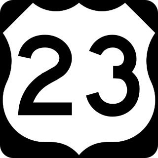
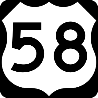
U.S. Route 421 (US 421) is a part of the U.S. Highway System that runs from Fort Fisher, North Carolina to Michigan City, Indiana. In Virginia, the U.S. Highway runs 69.23 miles (111.41 km) from the Tennessee state line between the twin cities of Bristol, Tennessee and Bristol, Virginia north and west to the Kentucky state line near St. Charles. Between its endpoints, US 421 has lengthy concurrencies with US 23 and US 58 during its course through Bristol, Weber City, Gate City, Duffield, and Pennington Gap in Southwest Virginia.

U.S. Route 23 (US 23) is a part of the United States Numbered Highway System that runs from Jacksonville, Florida, to Mackinaw City, Michigan. In Virginia, the U.S. Highway runs 60.80 miles (97.85 km) from the Tennessee state line near Weber City north to the Kentucky state line near Pound. US 23, which is known as Orby Cantrell Highway for most of its course, is a four-lane divided highway that follows Corridor B of the Appalachian Development Highway System through Southwest Virginia. The U.S. Highway serves as the main east–west highway of Scott County and the primary north–south highway of Wise County. US 23 runs concurrently with US 58 from Weber City to Duffield and with US 58 Alternate between Big Stone Gap and the independent city of Norton.

State Route 91 is a primary state highway in the U.S. state of Virginia. The state highway runs 55.12 miles (88.71 km) from the Tennessee state line near Damascus, where the highway continues as Tennessee State Route 91, north to U.S. Route 19 Business and US 460 Business at Frog Level. SR 91 connects Damascus in southeastern Washington County with the northeastern county town Glade Spring, where the highway has junctions with US 11 and Interstate 81 (I-81). The state highway also indirectly connects Saltville in northwestern Smyth County and Tazewell, the county seat of Tazewell County. SR 91 is the only primary state highway in Virginia with an unpaved section; this gravel section is in southern Tazewell County.

U.S. Route 58 Alternate is an 87.40-mile-long (140.66 km) alternate route to US 58 in western Virginia. The route is a northern bypass to US 58 which stays closer to the Tennessee border and serves Gate City and Bristol.

State Route 44 is a state highway in the U.S. state of Tennessee. It runs from US 11E/US 19W/SR 34 in Bluff City, just south of the split of US 19W and US 19E, northeast via Hickory Tree and Holston Valley to the Virginia state line, where it becomes Virginia State Route 75. The entire highway is located within Sullivan County.

State Route 67 is a state-maintained highway in northeastern Tennessee, including a four-lane divided highway segments in both Washington County and Carter County, and part of a significant two-lane segment passing over the Butler Bridge some 80 feet (24 m) above the TVA Watauga Reservoir near Butler in Johnson County, Tennessee.

U.S. Route 19 (US 19) traverses approximately 11.8 miles (19.0 km) across the Tri-Cities area of East Tennessee. The highway begins at Bluff City, where the highway splits into US 19E and US 19W, which both head into North Carolina and rejoin to form US 19 in North Carolina. US 19's Tennessee portion ends at the Virginia state line at the twin cities of Bristol, Tennessee, and Bristol, Virginia.

U.S. Route 421 is a north–south United States highway that runs for 43.4 miles (69.8 km) in East Tennessee, connecting the cities of Mountain City and Bristol.

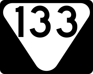
State Route 133 is a state route in northeastern Tennessee in Johnson County. It begins at Shady Valley and runs northward for about 11 miles (18 km) to the Tennessee–Virginia state border.

State Route 32 is a state highway in East Tennessee. For most of its route, it is an unsigned companion route concurrent with U.S. Route 25E. The highway stretches 89 miles from the North Carolina state line to the Tennessee-Kentucky state line near the town of Cumberland Gap.

State Route 167 is a state highway in Johnson County, Tennessee and a spur route of Tennessee State Route 67.

State Route 400 (SR 400) is a state highway in Washington and Carter counties in the U.S. state of Tennessee. It connects the cities of Johnson City, Watauga and Elizabethton.

State Route 34 is an unsigned state highway located in East Tennessee. The 155.7-mile-long (250.6 km) route traverses several cities through eight counties from the Knoxville area to the North Carolina state line via Greeneville and Bristol. The portion from Carter to Bristol is concurrent with U.S. Route 11E (US 11E) while the portion from Bristol to North Carolina is concurrent with US 421.

State Route 362, also known as Mary Patton Highway and Gap Creek Road, is a 5.7-mile-long (9.2 km) north-south state highway in Carter County, Tennessee.


