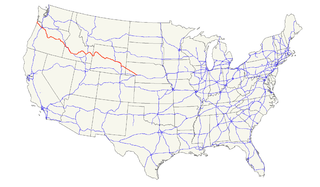
U.S. Route 26 is an east–west United States highway. It started in Ogallala, Nebraska, and was subsequently extended to the West Coast in Oregon. When the U.S. highway system was first defined, it was limited to Nebraska and Wyoming; by the 1950s, it continued into Idaho and Oregon. The highway's eastern terminus is in Ogallala, Nebraska at an intersection with Interstate 80. Its western terminus is south of Seaside, Oregon at an intersection with U.S. Route 101. Prior to 2004, the route's last 20 miles (32 km) were co-signed with U.S. Route 101 from the highways' junction south of Seaside north to Astoria where its intersection with U.S. Route 30 was also U.S. 30's western terminus.
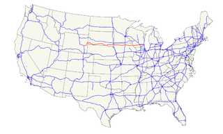
U.S. Route 18 is an east–west U.S. highway in the Midwestern United States. The western terminus is in Orin, Wyoming at an interchange with Interstate 25. Its eastern terminus is in downtown Milwaukee, Wisconsin. However, US 18 runs concurrent with other U.S. routes from its western terminus to Mule Creek Junction, Wyoming.
U.S. Route 310 (US 310) is a spur of U.S. Route 10. It runs for 108 miles (174 km) from Laurel, Montana, to Greybull, Wyoming. It passes through the states of Montana and Wyoming. Near the town of Lovell, Wyoming, US 310 is concurrent with US 14A for approximately 3 miles (4.8 km).
U.S. Route 189 is a spur of U.S. Route 89. It currently runs for 322 miles (518 km) from Provo, Utah at Interstate 15 to Jackson, Wyoming. The highway was not part of the original 1926 U.S. Highway system. The highway was created in the 1930s, absorbing former U.S. Route 530 and a portion of U.S. Route 30S. The portion through Provo Canyon has been designated the Provo Canyon Scenic Byway by the state of Utah.

U.S. Route 191 is a spur of U.S. Route 91 that has two branches. The southern branch runs for 1,465 miles (2,358 km) from Douglas, Arizona on the Mexican border to the southern part of Yellowstone National Park. The northern branch runs for 440 miles (710 km) from the northern part of Yellowstone National Park to Loring, Montana, at the Canada–US border. Unnumbered roads within Yellowstone National Park connect the two branches. The highway passes through the states of Arizona, Utah, Wyoming, and Montana.

Three Forks is a small unincorporated community in Pennington County, South Dakota, United States. It lies at the intersection of U.S. Routes 16 and 385, just north of Hill City along Spring Creek. A small general store featuring fuel is open year-round; other businesses are open seasonally, including a campground, a motel, a miniature golf-course, and an ice-cream stand. The campground is the site of an annual Octoberfest event, and the area is heavily patronized during the Sturgis Motorcycle Rally in August of each year. In recent years, considerable residential development of the immediate area has swollen its population.
Wyoming Highway 24 (WYO 24) is a 46.72-mile-long (75.19 km) Wyoming state highway known as the Bear Lodge Highway. The route passes through the northern portion of the Bear Lodge Mountains, part of the Black Hills National Forest. Highway 24 spans from U.S. Route 14 to the South Dakota state line, where it continues south as South Dakota Highway 34. The highway passes by Devils Tower National Monument.
Wyoming Highway 130 is a 98.52-mile-long (158.55 km) state highway in the U.S. State of Wyoming. It is known locally as the Snowy Range Road. It makes its way west from Laramie across the plains, and rises over the Medicine Bow Mountains. The road then turns north through the town of Saratoga, and ends at Interstate 80 (I-80). The stretch of road over the mountains is a National Forest Byway. WYO 130 over Snowy Range Pass is closed during winter (November–May)

U.S. Route 191 (US-191) is a major north–south state highway through the eastern part of the U.S. state of Utah. The present alignment of US-191, which stretches from Mexico to Canada, was created in 1981 through Utah. Previously the route had entered northern Utah, ending at US-91 in Brigham City, but with the completion of I-15 it was truncated to Yellowstone National Park and re-extended on a completely different alignment. In addition to a large portion of US-163, this extension absorbed several state routes: SR-33, most of SR-44, and SR-260.
In the U.S. state of Wyoming, U.S. Highway 14 runs east to west across the northern part of the state. The road connects South Dakota on the east with Yellowstone National Park on the west. It is mostly a two lane surface road except for several sections that it shares with Interstate 90.

Allen Junction is an unincorporated community in Wyoming County, West Virginia, United States. Their post office is still open.
Mule Creek Junction is an unpopulated locale in Niobrara County, Wyoming at the junction of US 18 and US 85.
Columbus and Ohio River Railroad is a railroad in the U.S. state of Ohio owned by Genesee & Wyoming Inc.
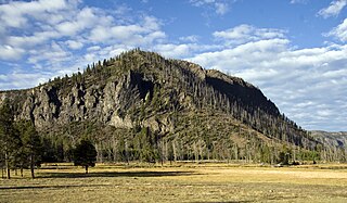
National Park Mountain is in Yellowstone National Park in the U.S. state of Wyoming. National Park Mountain rises above the confluence of the Firehole River and the Madison River and is just west of Madison Junction.
John Milton Thayer was a general in the Union Army during the American Civil War and a postbellum United States Senator from Nebraska. Thayer served as Governor of Wyoming Territory and Governor of Nebraska.
The Snake River Range is located in the U.S. states of Wyoming and Idaho and includes 10 mountains over 9,000 feet (2,700 m). The tallest peak in the range is Mount Baird at 10,030 feet (3,060 m). The range trends northwest to southeast and is bordered on the north by the Teton Range and the two ranges meet at Teton Pass. The Snake River Range is bordered by the Palisades Reservoir to the west and the Snake River, which sweeps completely around the eastern, southern and western part of the range. The range is approximate 30 miles (48 km) north to south and 33 miles (53 km) west to east, covering 528 square miles (1,370 km2). Along the southern boundary, the Snake River passes through Grand Canyon, also known as the Snake River Canyon. U.S. Route 26/U.S. Route 89 follows the course of the Snake River from Hoback Junction to the Palisades Reservoir.

Carlile Junction is the populated place in Wyoming where Wyoming Highway 24 has a terminus at US Route 14.
Border Junction or Border is a populated place and road intersection in the far western part of Lincoln County, Wyoming. US Route 30 is the major road, which leads northwest to Montpelier, Idaho, in Bear Lake County, and southeast to Cokeville, Wyoming. Wyoming Highway 89 runs north toward US Route 89, and southeast concurrently with US 30. Lincoln County Road 134 runs briefly south toward some homes and ranches. The Union Pacific Railroad passes Border Junction in the direction of Rock Springs to the east and Pocatello, Idaho, to the west.
U.S. Route 63 is the portion of a north-south highway that runs through Missouri from the Arkansas state line near Thayer to the Iowa state line near Lancaster.


