Granger, Wyoming

Last updated
Granger, Wyoming
Granger Stage Station.jpg
Granger stage station, built in 1856, on Old U.S. Route 30
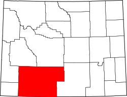
Sweetwater County Wyoming Incorporated and Unincorporated areas Granger Highlighted 5632870.svg
Location of Granger in Sweetwater County, Wyoming.
Usa edcp location map.svg
Red pog.svg
Granger, Wyoming
Location in the United States
Coordinates: 41°35′39″N109°58′0″W / 41.59417°N 109.96667°W / 41.59417; -109.96667 Coordinates: 41°35′39″N109°58′0″W / 41.59417°N 109.96667°W / 41.59417; -109.96667
Country United States
State Wyoming
County Sweetwater
Area
[1]
  Total2.59 sq mi (6.70 km2)
  Land2.59 sq mi (6.70 km2)
  Water0.00 sq mi (0.00 km2)
Elevation
[2]
6,273 ft (1,912 m)
Population
 (2010) [3]
  Total139
  Estimate 
(2019) [4]
128
  Density49.46/sq mi (19.10/km2)
Time zone UTC-7 (Mountain (MST))
  Summer (DST) UTC-6 (MDT)
ZIP code
82934
Area code(s) 307
FIPS code 56-32870 [5]
GNIS feature ID1589030 [2]

Granger is a town along Blacks Fork near the western edge of Sweetwater County, Wyoming, United States. [2] The population was 139 at the 2010 census. It is located near the confluence of the Blacks Fork and the Hams Fork rivers. The geography of the area is flat with semi-arid scrub.

Contents

Early history: 1834–1868

Although the population has always been small, the site is located at the intersection of the Oregon Trail and the Overland Stage Trail and it was chosen for a stage coach station. [6] The station, which was built of stone and adobe in 1856, was in operation when Mark Twain passed through, and still stands today. [7] The Pony Express used this station [8] as a stopover in 1861-62. Later, in 1868, it became a stop on the railroad, which was when it started to be called Granger. [7]

The area of what is present-day Granger had significance to the mountain men who trapped in the early years of the American West. It was chosen as the site of their annual rendezvous in 1834 [8] (the rendezvous was still somewhat spread out, as each supplier set up camp at different location along the river). [9] The American Fur Company, among other suppliers, were present, and American Indians and trappers traded furs for goods. Several weeks were spent recounting events from the previous year and reveling in assorted amusements, while lubricated with liquor. The records show that the event occurred at the junction of the Hams Fork and Blacks Fork rivers. [9]

Geography

Granger is located at 41°35′39″N109°58′0″W / 41.59417°N 109.96667°W / 41.59417; -109.96667 (41.594036, -109.966607). [10]

According to the United States Census Bureau, the town has a total area of 2.53 square miles (6.55 km2), all land. [11]

Demographics

Historical population
CensusPop.
1920 136
1930 135−0.7%
1940 16320.7%
1950 122−25.2%
1960 15930.3%
1970 137−13.8%
1980 17729.2%
1990 126−28.8%
2000 14615.9%
2010 139−4.8%
2019 (est.)128 [4] −7.9%
U.S. Decennial Census [12]

2010 census

As of the census [3] of 2010, there were 139 people, 57 households, and 38 families living in the town. The population density was 54.9 inhabitants per square mile (21.2/km2). There were 72 housing units at an average density of 28.5 per square mile (11.0/km2). The racial makeup of the town was 88.5% White, 0.7% African American, 9.4% from other races, and 1.4% from two or more races. Hispanic or Latino of any race were 15.1% of the population.

There were 57 households, of which 24.6% had children under the age of 18 living with them, 54.4% were married couples living together, 3.5% had a female householder with no husband present, 8.8% had a male householder with no wife present, and 33.3% were non-families. 21.1% of all households were made up of individuals, and 5.3% had someone living alone who was 65 years of age or older. The average household size was 2.44 and the average family size was 2.82.

The median age in the town was 39.5 years. 25.2% of residents were under the age of 18; 5.7% were between the ages of 18 and 24; 23.8% were from 25 to 44; 38.1% were from 45 to 64; and 7.2% were 65 years of age or older. The gender makeup of the town was 54.7% male and 45.3% female.

2000 census

As of the census [5] of 2000, there were 146 people, 54 households, and 40 families living in the town. The population density was 59.0 people per square mile (22.8/km2). There were 76 housing units at an average density of 30.7 per square mile (11.9/km2). The racial makeup of the town was 82.19% White, 8.22% from other races, and 9.59% from two or more races. Hispanic or Latino of any race were 22.60% of the population.

There were 54 households, out of which 35.2% had children under the age of 18 living with them, 68.5% were married couples living together, 5.6% had a female householder with no husband present, and 25.9% were non-families. 24.1% of all households were made up of individuals, and 5.6% had someone living alone who was 65 years of age or older. The average household size was 2.70 and the average family size was 3.18.

In the town, the population was spread out, with 28.8% under the age of 18, 10.3% from 18 to 24, 18.5% from 25 to 44, 33.6% from 45 to 64, and 8.9% who were 65 years of age or older. The median age was 38 years. For every 100 females, there were 100.0 males. For every 100 females age 18 and over, there were 116.7 males.

The median income for a household in the town was $46,563, and the median income for a family was $52,083. Males had a median income of $45,750 versus $19,375 for females. The per capita income for the town was $17,764. There were 10.5% of families and 12.3% of the population living below the poverty line, including 5.7% of under eighteens and 21.1% of those over 64.

Education

Public education in the town of Granger is provided by Sweetwater County School District #2.

Granger has a public library, a branch of the Sweetwater County Library System. [13]

See also

Related Research Articles

Sweetwater County, Wyoming County in Wyoming, United States

Sweetwater County is a county in southwestern Wyoming, United States. As of the 2020 United States Census, the population was 42,272, making it the fourth-most populous county in Wyoming. Its county seat is Green River. By area, it is the largest county in Wyoming. Its southern boundary line abuts the north lines of the states of Colorado and Utah.

Park County, Wyoming County in Wyoming, United States

Park County is a county in the U.S. state of Wyoming. As of the 2020 United States Census, the population was 29,624. The county seat is Cody.

Fremont County, Wyoming County in Wyoming, United States

Fremont County is a county in the U.S. state of Wyoming. As of the 2020 United States Census, the population was 39,234, making it the fifth-most populous county in Wyoming. Its county seat is Lander. The county was founded in 1884 and is named for John C. Frémont, a general, explorer, and politician. It is roughly the size of the state of Vermont.

Belfry, Montana Census-designated place in Montana, United States

Belfry is a census-designated place (CDP) in Carbon County, Montana, United States. It is part of the Billings, Montana Metropolitan Statistical Area. The population was 218 at the 2010 census. It is located approximately 11 miles (18 km) from the Wyoming border, roughly halfway between Billings, Montana and Cody, Wyoming.

Trout Creek, Montana CDP in Montana, United States

Trout Creek is a census-designated place (CDP) in Sanders County, Montana, United States. The population was 261 at the 2000 census. Trout Creek was proclaimed "Huckleberry Capital of Montana" by the state's legislature in 1981.

Pringle, South Dakota Town in South Dakota, United States

Pringle is a town in Custer County, South Dakota, United States. The population was 112 at the 2010 census.

Follansbee, West Virginia City in West Virginia, United States

Follansbee is a city in Brooke County, West Virginia, United States, located along the Ohio River. It is part of the Weirton-Steubenville, WV-OH Metropolitan Statistical Area. The population was 2,986 at the 2010 census.

Pinedale, Wyoming Town in Wyoming, United States

Pinedale is a town in and the county seat of Sublette County, Wyoming, United States. The population was 2,030 at the 2010 census. Pinedale is an important hunting outfitting town and a gateway to the Wind River Mountains. It is also a major gateway to the Jackson Hole area in Wyoming. Additionally, Pinedale is near several large natural gas fields, including the Pinedale Anticline and Jonah Field. Attractions include the Museum of the Mountain Man, Green River Rendezvous Days, White Pine Ski Area, the Pinedale Aquatic Center and the Town Park System along the Pine Creek Corridor in the middle of town. The mayor is Matt Murdock, who was elected in 2018.

Arrowhead Springs is a census-designated place (CDP) in Sweetwater County, Wyoming, United States. The population was 63 at the 2010 census.

Bairoil, Wyoming Town in Wyoming, United States

Bairoil is a town in Sweetwater County, Wyoming, United States. The population was 106 at the 2010 census.

Eden, Wyoming CDP in Wyoming, United States

Eden is a census-designated place (CDP) in Sweetwater County, Wyoming, United States. The population was 281 at the 2010 census.

Green River, Wyoming City in Wyoming, United States

Green River is a city in and the county seat of Sweetwater County, Wyoming, United States, in the southwestern part of the state. The population was 12,515 at the 2010 census.

James Town, Wyoming CDP in Wyoming, United States

James Town is a census-designated place (CDP) in Sweetwater County, Wyoming, United States. The population was 536 at the 2010 census.

McKinnon, Wyoming Census-designated place in Sweetwater County, Wyoming, United States

McKinnon is a census-designated place (CDP) in Sweetwater County, Wyoming, United States. The population was 60 at the 2010 census.

North Rock Springs is a census-designated place (CDP) in Sweetwater County, Wyoming, United States. The population was 2,207 at the 2010 census.

Reliance, Wyoming CDP in Wyoming, United States

Reliance is a census-designated place (CDP) in Sweetwater County, Wyoming, United States. The population was 714 at the 2010 census.

Superior, Wyoming Town in Wyoming, United States

Superior is a town in Sweetwater County, Wyoming, United States. The population was 336 at the 2010 census.

Sweeney Ranch is an unincorporated community in Sweetwater County, Wyoming, United States. The population was 17 at the 2000 census, when it was a census-designated place (CDP).

Wamsutter, Wyoming Town in Wyoming, United States

Wamsutter is a town in Sweetwater County, Wyoming, United States. The population was 451 at the 2010 census.

Washam is a census-designated place (CDP) in Sweetwater County, Wyoming, United States. The population was 51 at the 2010 census.

References

  1. "2019 U.S. Gazetteer Files". United States Census Bureau. Retrieved August 7, 2020.
  2. 1 2 3 U.S. Geological Survey Geographic Names Information System: Granger, Wyoming
  3. 1 2 "U.S. Census website". United States Census Bureau . Retrieved 2012-12-14.
  4. 1 2 "Population and Housing Unit Estimates". United States Census Bureau. May 24, 2020. Retrieved May 27, 2020.
  5. 1 2 "U.S. Census website". United States Census Bureau . Retrieved 2008-01-31.
  6. "About Granger". Untraveled Road.
  7. 1 2 "Granger Stage Station Historic Site". Wyoming State Parks. Archived from the original on 2014-08-23. Retrieved 2012-12-23.
  8. 1 2 Official State Highway Map of Wyoming (Map). Wyoming Department of Transportation. 2014.
  9. 1 2 "Mountain Man Rendezvous Sites". furtrapper.com. Archived from the original on 2012-11-15.
  10. "US Gazetteer files: 2010, 2000, and 1990". United States Census Bureau. 2011-02-12. Retrieved 2011-04-23.
  11. "US Gazetteer files 2010". United States Census Bureau. Archived from the original on 2012-01-25. Retrieved 2012-12-14.
  12. "Census of Population and Housing". Census.gov. Retrieved June 4, 2015.
  13. "Wyoming Public Libraries". PublicLibraries.com. Retrieved 14 June 2019.

Commons-logo.svg Media related to Granger, Wyoming at Wikimedia Commons