Sweeney Ranch, Wyoming

Last updated
Sweeney Ranch, Wyoming
USA Wyoming location map.svg
Red pog.svg
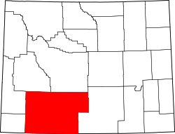
Sweeney Ranch, Wyoming
Location within the state of Wyoming
Usa edcp location map.svg
Red pog.svg
Sweeney Ranch, Wyoming
Sweeney Ranch, Wyoming (the United States)
Coordinates: 41°28′23″N109°0′52″W / 41.47306°N 109.01444°W / 41.47306; -109.01444 Coordinates: 41°28′23″N109°0′52″W / 41.47306°N 109.01444°W / 41.47306; -109.01444
Country United States
State Wyoming
County Sweetwater
Area
  Total8.1 sq mi (21.0 km2)
  Land8.1 sq mi (21.0 km2)
  Water0.0 sq mi (0.0 km2)
Elevation
6,696 ft (2,041 m)
Population
 (2000)
  Total17
  Density2.1/sq mi (0.8/km2)
Time zone UTC-7 (Mountain (MST))
  Summer (DST) UTC-6 (MDT)
Area code(s) 307
FIPS code 56-75137 [1]
GNIS feature ID1853213 [2]

Sweeney Ranch is an unincorporated community in Sweetwater County, Wyoming, United States. The population was 17 at the 2000 census, when it was a census-designated place (CDP).

Contents

Geography

Sweeney Ranch is located at 41°28′23″N109°0′52″W / 41.47306°N 109.01444°W / 41.47306; -109.01444 (41.473176, -109.014468). [3]

According to the United States Census Bureau, in 2000 the CDP had a total area of 8.1 square miles (21.0 km2), all of it land.

Demographics

As of the census [1] of 2000, there were 17 people, 6 households, and 4 families residing in the CDP. The population density was 2.1 people per square mile (0.8/km2). There were 7 housing units at an average density of 0.9/sq mi (0.3/km2). The racial makeup of the CDP was 100.00% White.

There were 6 households, out of which 33.3% had children under the age of 18 living with them, 66.7% were married couples living together, 16.7% had a female householder with no husband present, and 16.7% were non-families. 16.7% of all households were made up of individuals, and none had someone living alone who was 65 years of age or older. The average household size was 2.83 and the average family size was 3.20.

In the CDP the population was spread out, with 17.6% under the age of 18, 17.6% from 18 to 24, 11.8% from 25 to 44, 52.9% from 45 to 64, . The median age was 46 years. For every 100 females, there were 112.5 males. For every 100 females age 18 and over, there were 100.0 males.

The median income for a household in the CDP was $31,250, and the median income for a family was $0. Males had a median income of $31,250 versus $0 for females. The per capita income for the CDP was $31,000. None of the population or the families were below the poverty line.

Education

Public education in the community of Sweeney Ranch is provided by two school districts - Sweetwater County School District #1 and Sweetwater County School District #2.

Related Research Articles

Pirtleville, Arizona CDP in Arizona, United States

Pirtleville is a census-designated place (CDP) in Cochise County, Arizona, United States. The population was 1,744 at the 2010 census.

Greasewood, Arizona CDP in Arizona, United States

Greasewood is a census-designated place (CDP) in Navajo County, Arizona, United States. The population was 547 at the 2010 census.

Foothill Ranch, Lake Forest, California Human settlement in California, United States of America

Foothill Ranch (FHR) was a census-designated place in Orange County, California, United States. The population was 10,899 at the 2000 census. Foothill Ranch was incorporated into Lake Forest, California, in 2000.

Maunaloa, Hawaii Census-designated place in Hawaii, United States

Maunaloa or Mauna Loa is a census-designated place (CDP) in Maui County, Hawaiʻi, United States, in the western part of the island of Molokai. The population was 376 at the 2010 census.

St. Leonard, Maryland Census-designated place in Maryland

St. Leonard is a census-designated place (CDP) in Calvert County, Maryland, United States. The population was 742 at the 2010 census. Residents of the Calvert Beach and Long Beach communities also use the St. Leonard ZIP code designation. St. Leonard has a large antique dealer complex.

Littleton Common, Massachusetts Census-designated place in Massachusetts, United States

Littleton Common is a census-designated place (CDP) in the town of Littleton in Middlesex County, Massachusetts, United States. The population was 2,789 at the 2010 census.

India Hook, South Carolina CDP in South Carolina, United States

India Hook is a census-designated place (CDP) in York County, South Carolina, United States. Majority of India Hook is annexed into the city of Rock Hill, but as of 2010 India Hook is still considered to be a CDP. It is one of the three communities located on Lake Wylie.

Pawnee, Texas Census-designated place in Texas, United States

Pawnee is a census-designated place (CDP) in Bee County, Texas, United States. The population was 166 at the 2010 census.

Arrowhead Springs, Wyoming CDP in Wyoming, United States

Arrowhead Springs is a census-designated place (CDP) in Sweetwater County, Wyoming, United States. The population was 63 at the 2010 census.

Clearview Acres, Wyoming CDP in Wyoming, United States

Clearview Acres is a census-designated place (CDP) in Sweetwater County, Wyoming, United States. The population was 795 at the 2010 census.

Eden, Wyoming CDP in Wyoming, United States

Eden is a census-designated place (CDP) in Sweetwater County, Wyoming, United States. The population was 281 at the 2010 census.

Farson, Wyoming CDP in Wyoming, United States

Farson is a census-designated place (CDP) in Sweetwater County, Wyoming, United States. The population was 313 at the 2010 census.

James Town, Wyoming CDP in Wyoming, United States

James Town is a census-designated place (CDP) in Sweetwater County, Wyoming, United States. The population was 536 at the 2010 census.

Little America, Wyoming CDP in Wyoming, United States

Little America is a census-designated place (CDP) in Sweetwater County, Wyoming, United States. The population was 68 at the 2010 census. The community got its name from the Little America motel, which was purposefully located in a remote location as a haven, not unlike the base camp the polar explorer Richard E. Byrd set up in the Antarctic in 1928. However, being situated on a coast-to-coast highway and offering travel services, it thrived, launching a chain of travel facilities by the same name. Its developer, Robert Earl Holding, died on April 19, 2013, with a personal net worth of over $3 billion.

McKinnon, Wyoming CDP in Wyoming, United States

McKinnon is a census-designated place (CDP) in Sweetwater County, Wyoming, United States. The population was 60 at the 2010 census.

North Rock Springs, Wyoming CDP in Wyoming, United States

North Rock Springs is a census-designated place (CDP) in Sweetwater County, Wyoming, United States. The population was 2,207 at the 2010 census.

Purple Sage, Wyoming CDP in Wyoming, United States

Purple Sage is a census-designated place (CDP) in Sweetwater County, Wyoming, United States. The population was 535 at the 2010 census.

Reliance, Wyoming CDP in Wyoming, United States

Reliance is a census-designated place (CDP) in Sweetwater County, Wyoming, United States. The population was 714 at the 2010 census.

Washam, Wyoming CDP in Wyoming, United States

Washam is a census-designated place (CDP) in Sweetwater County, Wyoming, United States. The population was 51 at the 2010 census.

Catawba is a town in Price County, Wisconsin, United States. The population was 283 at the 2000 census. The Village of Catawba is located within the town.

References

  1. 1 2 "U.S. Census website". United States Census Bureau . Retrieved 2008-01-31.
  2. "US Board on Geographic Names". United States Geological Survey. 2007-10-25. Retrieved 2008-01-31.
  3. "US Gazetteer files: 2010, 2000, and 1990". United States Census Bureau. 2011-02-12. Retrieved 2011-04-23.