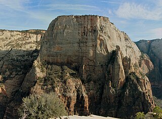
The Great White Throne is a monolith, predominantly composed of white Navajo Sandstone in Zion National Park in Washington County in southwestern Utah, United States. The north-west "main" face rises 2,350 feet (720 m) in 1,500 feet (460 m) from the floor of Zion Canyon near Angels Landing. It is often used as a symbol of Zion National Park. The Great White Throne can be seen from most locations along the scenic drive running through Zion Canyon.

Bee Hive is a 6,904 feet (2,104 m) Navajo Sandstone mountain in Zion National Park in Washington County, Utah, United States, that is part of the Towers of the Virgin.

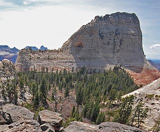
Bridge Mountain is a 6,803-foot (2,074 m) mountain made of Navajo Sandstone in Zion National Park in Washington County, of southwest Utah, United States.

Mount Spry is a small 5,720-ft elevation mountain summit made of Navajo Sandstone located in Zion National Park, in Washington County of southwest Utah, United States. Officially named in 1934, it honors William Spry (1864–1929), the third governor of Utah. The nearest higher peak is The East Temple, 0.34 miles (0.55 km) to the east. Precipitation runoff from the mountain drains into tributaries of the North Fork Virgin River.

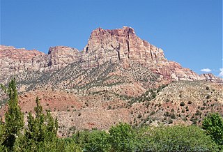
The East Temple is a prominent 7,709 feet (2,350 m) summit composed of Navajo Sandstone in Zion National Park, in Washington County of southwest Utah, United States. It is one of the notable landmarks in the park. The nearest neighbor is Twin Brothers, one-half mile to the north, and the nearest higher peak is The West Temple, 3.85 miles (6.20 km) to the west-southwest. The mountain is situated 1.8 miles northeast of the park headquarters, at the confluence of Pine Creek and the North Fork Virgin River. This feature's name was applied by John Wesley Powell during his explorations in 1872, and was officially adopted in 1934 by the U.S. Board on Geographic Names. The first ascent was made in 1937 by Glen Dawson, Dick Jones, Homer Fuller, Wayland Gilbert, and Jo Momyer.

The Watchman is a 6,545-foot (1,995 m) sandstone mountain summit located in Zion National Park, in Washington County of southwest Utah, United States.

Mount Kinesava is a 7,285-foot (2,220 m) sandstone mountain summit located in Zion National Park, in Washington County of southwest Utah, United States.
Johnson Mountain is a 6,106-foot (1,861 m) Navajo Sandstone summit located in Zion National Park, in Washington County of southwest Utah, United States.

Mount Moroni is a 5,690-foot (1,730 m) elevation Navajo Sandstone summit located at the Court of the Patriarchs in Zion National Park, in Washington County of southwest Utah, United States.

Twin Brothers is a 6,863-foot (2,092 m) Navajo Sandstone mountain in Zion National Park in Washington County, Utah, United States.
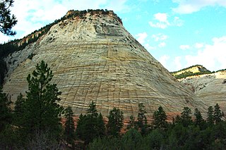
Checkerboard Mesa is an iconic 6,520+ ft elevation Navajo Sandstone summit located in Zion National Park, in Kane County of southwest Utah, United States. Checkerboard Mesa is situated immediately southwest of the park's east entrance, towering 900 feet above the Zion – Mount Carmel Highway. Its nearest neighbor is Crazy Quilt Mesa, one-half mile immediately west, and separated by Checkerboard Mesa Canyon. This canyon holds pools of rainwater which provide a vital source of water for resident bighorn sheep. This peak was originally named Checkerboard Mountain by the park's third superintendent, Preston P. Patraw. The landform's toponym was officially adopted in 1935 by the U.S. Board on Geographic Names. The descriptive name stems from the cliff's distinctive multitudinous check lines in cross-bedded white sandstone which give the impression of a checkerboard. The horizontal lines are caused by cross-bedding, a remnant of ancient sand dunes. The vertical and sub-vertical lines formed by the contraction and expansion of the sandstone caused by temperature changes, freezing and thawing cycles, in combination with wetting and drying. Precipitation runoff from this mountain drains into tributaries of the Virgin River.

Inclined Temple is a remote 7,150-foot elevation summit located in Zion National Park, in Washington County of southwest Utah, United States.
South Guardian Angel is a 7,140-foot (2,180 m) summit located in Zion National Park, in Washington County of southwest Utah, United States.
North Guardian Angel is a 7,395-foot elevation summit located in Zion National Park, in Washington County of southwest Utah, United States.

The Sundial is a 7,590-foot (2,310-meter) elevation white Navajo Sandstone summit located in Zion National Park, in Washington County of southwest Utah, United States.

The Witch Head is a 7,340-foot (2,240 m) white Navajo Sandstone mountain in Zion National Park in Washington County, Utah, United States, that is part of the Towers of the Virgin.

Ant Hill is a 6,641-foot (2,024 m) summit located in Zion National Park, in Washington County of southwest Utah, United States. It is composed of white Navajo Sandstone, and rises 1,400 feet above the Zion – Mount Carmel Highway. Ant Hill is situated 1.65 mi (2.66 km) east-northeast of The East Temple, and 2.4 mi (3.9 km) west-northwest of Checkerboard Mesa. Precipitation runoff from this mountain drains into tributaries of the Virgin River. Despite its benign name, an ascent of this mountain is a dangerous and exposed climb.

Crazy Quilt Mesa is a 6,760 ft (2,060 m) elevation white Navajo Sandstone summit located in Zion National Park, in Kane County of southwest Utah, United States.

Paria Point is a 7,802-foot (2,378 m) elevation summit located in the Kolob Canyons section of Zion National Park, in Washington County, Utah, United States. Tucupit Point is situated 0.5 mi (0.80 km) immediately north, and Beatty Point is 0.5 mi (0.80 km) immediately south, with 2,000-foot-deep finger canyons between each. Other neighbors include Nagunt Mesa and Timber Top Mountain to the south, and Horse Ranch Mountain to the north. Paria Point is composed of Jurassic Navajo sandstone overlaying tilted Kayenta Formation. Precipitation runoff drains into Taylor Creek, which is part of the Virgin River drainage basin. This feature's paria name is a Paiute word meaning "muddy water" or "elk water".

Eagle Crags is a 6,380-foot (1,940 m) elevation summit located in the Canaan Mountain Wilderness of Washington County in southwest Utah, United States.


