Snoqualmie Pass is a mountain pass that carries Interstate 90 (I-90) through the Cascade Range in the U.S. state of Washington. The pass summit is at an elevation of 3,015 feet (919 m), on the county line between Kittitas County and King County.
Breccia Peak is a mountain summit in the North Cascades, in Snohomish County of Washington state. Its summit is 6,487 feet (1,977 m) above sea level. The peak is the eroded remnant of a stratovolcano, and takes its name from the type of rock, breccia, that it is composed of. It is located 15 miles southeast of Darrington, Washington, and 8.7 miles (14.0 km) west of Glacier Peak, which is one of the Cascade stratovolcanoes. It is situated in the Glacier Peak Wilderness on land administered by the Mount Baker-Snoqualmie National Forest. The nearest higher peak is Mount Pugh, 3.5 miles (5.6 km) to the northwest. Precipitation runoff from Breccia Peak drains into tributaries of the Sauk River.

Tomyhoi Peak is a 7,439-foot (2,267-metre) Skagit Range mountain situated one mile south of the Canada–United States border, in the North Cascades of Washington state. It is located west of Mount Larrabee and within the Mount Baker Wilderness, which is part of the Mount Baker-Snoqualmie National Forest. This mountain's toponym was officially adopted in 1913 by the U.S. Board on Geographic Names.

Kendall Peak is a mountain located on the county line separating King County and Kittitas County of Washington state. It is within the Alpine Lakes Wilderness on the crest of the Cascade Range. Kendall Peak is situated two miles northeast of Snoqualmie Pass on land managed by Mount Baker-Snoqualmie National Forest. Precipitation runoff on the east side of the mountain drains into Silver Creek and makes its way to the Columbia River via Yakima River, whereas the west side of the mountain drains into the South Fork Snoqualmie River via Commonwealth Creek. The Pacific Crest Trail traverses its west flank and an exposed section of the trail called Kendall Katwalk has seen tragic deaths over the years, most recently September 5, 2018. The nearest higher peak is Red Mountain, 0.9 miles (1.4 km) to the north-northwest.

Del Campo Peak is a prominent summit near the western edge of the North Cascades, in Snohomish County of Washington state. It is located south of Barlow Pass along the Mountain Loop Highway near the Monte Cristo area. It is situated on land administered by the Mount Baker-Snoqualmie National Forest. The mountain is named for a mining claim on the mountain's slope. The nearest peak is Gothic Peak, 0.5 miles (0.80 km) to the southwest, and Foggy Pass is the low point between the two peaks. Foggy Lake lies in Gothic Basin below the south face of Del Campo Peak and collects precipitation runoff which ultimately drains to South Fork Sauk River via Weden Creek. Runoff from the west side of the mountain drains into the Sultan River, and the north side drains into headwaters of the Stillaguamish River. In terms of favorable weather, the best months for climbing are July through September.
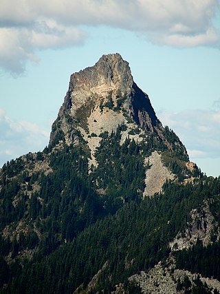
Kaleetan Peak is a prominent 6,259-foot (1,908-metre) mountain summit located in King County of Washington state. It's part of the Cascade Range and is situated four miles northwest of Snoqualmie Pass. Kaleetan Peak is set within the Alpine Lakes Wilderness on land managed by Mount Baker-Snoqualmie National Forest. It's immediately west of Melakwa Pass and Chair Peak, and north of Melakwa Lake. Precipitation runoff from the mountain drains into tributaries of the Snoqualmie River. Topographic relief is significant as the summit rises approximately 2,400 feet (730 m) above Kaleetan Lake in 0.6 mi (0.97 km). The nearest higher peak is Snoqualmie Mountain, 2.89 miles (4.65 km) to the east. The mountain's name "Kaleetan" derives from Chinook Jargon which means "arrow". The peak was named by members of The Mountaineers and the toponym was officially adopted in 1916 by the U.S. Board on Geographic Names.

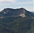
Huckleberry Mountain is a 6,320+ ft summit located on the shared border of King County and Kittitas County in Washington state.
Silver Peak is a prominent 5,609 ft (1,710 m) mountain located on the shared border between King County and Kittitas County of Washington state. It is set on the crest of the Cascade Range, on land managed by Mount Baker-Snoqualmie National Forest. Silver Peak is situated 4.5 miles southwest of Snoqualmie Pass, and three miles west of Keechelus Lake. The Pacific Crest Trail traverses its east flank and provides easiest access. The nearest higher neighbor is Granite Mountain, 3.98 miles (6.41 km) to the north-northwest. Precipitation runoff from the east side of the mountain drains into Cold Creek, a tributary of the Yakima River, whereas the west side of the mountain drains into the South Fork Snoqualmie River via Humpback Creek.

Snowking Mountain is a 7,433-foot (2,266-metre) summit located in Skagit County of Washington state. Situated within the Glacier Peak Wilderness, Snowking Mountain is positioned west of the crest of the North Cascades, approximately 18 miles northeast of the town of Darrington. It is set within the Glacier Peak Wilderness, on land managed by Mount Baker–Snoqualmie National Forest. Snowking has two subsidiary peaks, West Peak (7,425 ft), and Middle Peak (7,400 ft). A broad unnamed glacier known colloquially as Snowking Glacier rests on the north face. Downslope of that glacier are Snowking Lake, Found Lake, and Cyclone Lake. Mount Tommy Thompson is three miles to the northwest, and the nearest higher neighbor is Mount Misch, 5.75 miles (9.25 km) to the southeast. Precipitation runoff from Snowking Mountain drains into tributaries of the Skagit River.

Summit Chief Mountain is a 7,467-foot (2,276-meter) mountain summit located on the county line separating King County and Kittitas County in Washington state. It is entirely within the Alpine Lakes Wilderness, on land managed by Mount Baker-Snoqualmie National Forest. Summit Chief Mountain is situated on the crest of the Cascade Range, nine miles northeast of Snoqualmie Pass. Precipitation runoff from the west side of the mountain drains into tributaries of the Snoqualmie River, whereas the east side drains into tributaries of the Yakima River. The nearest higher peak is Chimney Rock, 1.29 miles (2.08 km) to the southwest.

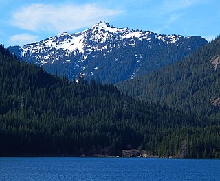
Mount Thomson is a prominent 6,554-foot-elevation (1,998-meter) mountain summit in eastern King County of Washington state.

Alaska Mountain is a 5,745-foot (1,751-metre) mountain summit located in the Cascade Range, in Kittitas County of Washington state. It is situated within the Alpine Lakes Wilderness on land managed by Wenatchee National Forest. Alaska Mountain is set between Alaska Lake and Joe Lake, 8 miles (13 km) northeast of Snoqualmie Pass, and 0.81 miles (1.30 km) southeast of Mount Thomson, which is also its nearest higher peak. The Pacific Crest Trail traverses around the south, east and north slopes of Alaska Mountain, and an off-trail hike leads to the summit. Precipitation runoff on the east side of the mountain drains into tributaries of the Yakima River, whereas the west side of the peak drains into tributaries of the Snoqualmie River.

Little Big Chief Mountain is a 7,225-foot (2,202-metre) mountain summit located immediately southwest of Dutch Miller Gap, on the common border separating King County and Kittitas County in Washington state. It is situated within the Alpine Lakes Wilderness, on land managed by Mount Baker-Snoqualmie National Forest. Little Big Chief Mountain is set ten miles northeast of Snoqualmie Pass on the crest of the Cascade Range. Precipitation runoff from the west side of the mountain drains into tributaries of the Snoqualmie River, whereas the east side drains into tributaries of the Yakima River. The nearest higher peak is Summit Chief Mountain, 0.7 miles (1.1 km) to the southwest, and Chimney Rock is set 2.2 miles (3.5 km) to the southwest. The first ascent of this peak was made in August 1939 by Fred Beckey, Wayne Swift, Joe Barto, and Campbell Brooks. This mountain was named for Lorenz A. Nelson during the 1925 Mountaineers climb of Summit Chief Mountain. Nelson was a pioneering mountaineer who led first ascents of Mount Olympus, Mount Meany, and Chiwawa Mountain.

La Bohn Peak is a 6,585-foot (2,007-metre) mountain summit located two miles north of Dutch Miller Gap, in east King County of Washington state. It is situated at the head of Necklace Valley, in the heart of the Alpine Lakes Wilderness, on land managed by Mount Baker-Snoqualmie National Forest. La Bohn Peak is set west of La Bohn Lakes and La Bohn Gap, and one mile west of the crest of the Cascade Range. Precipitation runoff from the south side of the mountain drains into tributaries of the Snoqualmie River, whereas the north side drains into tributaries of the Foss River. The nearest higher neighbor is Mount Hinman, 1.7 miles (2.7 km) to the east, Little Big Chief Mountain is set 2.3 miles (3.7 km) to the south, and Iron Cap Mountain sits 1.77 miles (2.85 km) to the west.

Iron Cap Mountain is a 6,347-foot (1,935-metre) mountain summit located two miles west-northwest of Dutch Miller Gap, in east King County of Washington state. It is situated in the heart of the Alpine Lakes Wilderness, on land managed by Mount Baker-Snoqualmie National Forest. Iron Cap Mountain is set two miles west of the crest of the Cascade Range. Precipitation runoff from the south side of the mountain drains into tributaries of the Snoqualmie River, whereas the north side drains into tributaries of the Foss River. Although modest in elevation, relief is significant since Iron Cap rises 2,500 feet above the Middle Fork Snoqualmie River Valley in less than one mile. Its neighbors include La Bohn Peak, 1.77 miles (2.85 km) to the east, and Little Big Chief Mountain, 2.14 miles (3.44 km) to the southeast.

Castle Mountain is a 6,680-foot (2,036 m) mountain summit located in Pierce County of Washington state. It is set on the boundary of Norse Peak Wilderness, on land managed by Mount Baker-Snoqualmie National Forest. It is situated three miles (4.8 km) north of Crystal Mountain ski area, and one mile west of the crest of the Cascade Range. Precipitation runoff from Castle Mountain drains into tributaries of the White River. The Pacific Crest Trail traverses the east slope of Castle's Southeast Peak.

Kelly Butte is a 5,417-foot-elevation (1,651-meter) summit located in the southeast corner of King County in Washington state. It is set on land managed by Mount Baker-Snoqualmie National Forest. It is situated 3.1 mi (5.0 km) northwest of Colquhoun Peak and five miles west of the crest of the Cascade Range. Precipitation runoff from Kelly Butte drains into tributaries of the Green River. Topographic relief is significant as the west aspect rises 3,000 feet above Rock Creek in one mile. Access is via the 1.7-mile Kelly Butte Trail which leads to a restored, historical fire lookout tower originally constructed in 1926 and occupies the summit. Flora along the trail includes lilies, bear grass, Indian paintbrush, penstemon, arnica, columbine, lupine, phlox, and huckleberry. This geographical feature's name has been officially adopted by the U.S. Board on Geographic Names.

Abiel Peak is a 5,365 ft (1,640 m) mountain summit located in eastern King County of Washington state. It is set 1,000 feet west of the crest of the Cascade Range, on land managed by Mount Baker-Snoqualmie National Forest. Abiel Peak is situated six miles south-southwest of Snoqualmie Pass, and neighbors include Silver Peak, three-quarters mile to the north-northeast, Tinkham Peak three-quarters mile to the east, and Humpback Mountain two miles to the northwest. Precipitation runoff from the south side of the mountain drains into headwaters of Tinkham Creek which is a tributary of the North Fork Cedar River, whereas the north side of the mountain drains into Annette Lake, thence the South Fork Snoqualmie River via Humpback Creek. Topographic relief is significant as the north aspect rises 1,860 feet above Annette Lake in one-half mile.

Mailbox Peak is a 4,841-foot-elevation (1,476 m) mountain located in King County of Washington state. It is set west of the crest of the Cascade Range, on land managed by Mount Baker-Snoqualmie National Forest. Mailbox Peak is situated seven miles east of North Bend, and one mile northeast above the Washington State Fire Training Academy. Precipitation runoff from the south side of the mountain drains into the South Fork Snoqualmie River, whereas the north side drains to the Middle Fork of the Snoqualmie. The summit lies along a ridge containing Dirtybox Peak, its topographical parent, and Dirty Harry's Peak. Topographic relief is significant as the northwest aspect rises nearly 4,100 feet above the Middle Fork in 1.25 mile. The popular Mailbox Peak Trail gains 4,100 feet of elevation over 5.5 miles. Prior to 2014 when the new trail was completed, climbing Mailbox Peak involved 4,000 feet gain in only 2.6 miles along an unmaintained route that was used for conditioning for major climbs, and recruits from the Fire Training Academy would celebrate graduation by carrying a fire hydrant to the summit. The peak is named for a mailbox at the top which functions as the summit register, but this toponym has not been officially adopted by the U.S. Board on Geographic Names.

Foggy Peak is a 6,810-foot-elevation (2,076-meter) mountain summit in Snohomish County of Washington state.