Tokalon, Arkansas | |
|---|---|
 Tokalon, Arkansas  Tokalon, Arkansas | |
| Coordinates: 35°22′35″N93°28′17″W / 35.37639°N 93.47139°W | |
| Country | United States |
| State | Arkansas |
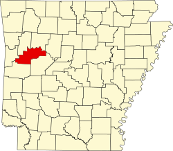
| County | Logan |
| Elevation | 436 ft (133 m) |
| Time zone | UTC-6 (Central (CST)) |
| • Summer (DST) | UTC-5 (CDT) |
| Area code | 479 |
| GNIS feature ID | 55588 [1] |
Tokalon is an unincorporated community in Logan County, Arkansas, United States. [1] [2]