
The Tombs of Malta are a series of prehistoric tombs in the Maltese archipelago.


The Tombs of Malta are a series of prehistoric tombs in the Maltese archipelago.

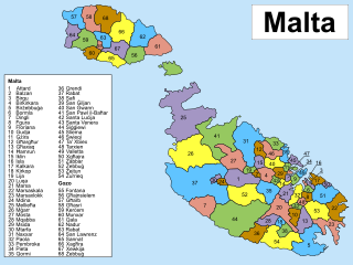
Since June 30, 1993, Malta has been subdivided into 68 localities, governed by local councils, Maltese: kunsilli lokali, meaning municipalities or borough, and the considered by the Maltese as the equivalent to a basic village or towns, where appropriate. These form the most basic type of local government and are subdivisions of the country's first-level regions.

A megalith is a large stone that has been used to construct a prehistoric structure or monument, either alone or together with other stones. There are over 35,000 structures or arrangements in Europe alone, located widely from Sweden to the Mediterranean sea.

Mġarr, formerly known as Mgiarro, is a village in the Northern Region of Malta. Mġarr is a rural village, isolated from nearby towns and cities. Mġarr lies west of Mosta and is surrounded by farmland and vineyards. Many of the 4,840 Imġarrin are farmers or otherwise engaged in agricultural activity.

Siġġiewi, also called by its title Città Ferdinand, is a city and a local council in the Southern Region of Malta. It is the third largest council in Malta by surface area, after Rabat and Mellieħa. Siġġiewi is situated on a plateau a few kilometers away from Mdina and 10 kilometres away from Valletta, the contemporary capital.

Rabat is a town in the Western Region of Malta, with a population of 11,497 as of March 2014. It adjoins the ancient capital city of Mdina, and a north-western area formed part of the Roman city of Melite until its medieval retrenchment.

Xemxija is a suburb in the western part of St. Paul's Bay in the Northern Region, Malta. It is a quiet resort, surrounded by the countryside and some of the most fertile valleys in Malta. There is also a picturesque small fishing harbour. The resort is the gateway to the sandy beaches of Golden Bay and to Mellieħa Bay. There are a number of hotels and restaurants in Xemxija.
Xlendi is an urban village in Malta situated in the south-west of the island of Gozo. It is surrounded by the villages of Munxar, Fontana and Kerċem. The village is administered by Munxar, but has its own coat of arms and motto. From March 2010, Xlendi has had its own 5-person "mini council" responsible for the main activities of the area.

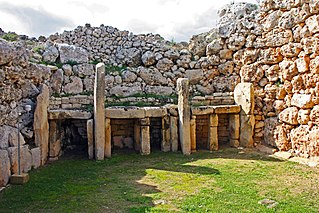
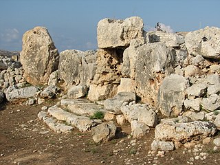
The Megalithic Temples of Malta are several prehistoric temples, some of which are UNESCO World Heritage Sites, built during three distinct periods approximately between 3600 BC and 2500 BC on the island country of Malta. They had been claimed as the oldest free-standing structures on Earth until the discovery of Göbekli Tepe in Turkey. Archaeologists believe that these megalithic complexes are the result of local innovations in a process of cultural evolution. This led to the building of several temples of the Ġgantija phase, culminating in the large Tarxien temple complex, which remained in use until 2500 BC. After this date, the temple-building culture disappeared.
This article describes several characteristic architectural elements typical of European megalithic structures.
This page list topics related to Malta.

The coastline of Malta consists of bays, sandy beaches, creeks, harbours, small villages, cities, cliffs, valleys, and other interesting sites. Here, there is a list of these different natural features that are found around the coast of Malta.
The Megalithic Portal is a web resource dedicated to prehistoric archaeology and closely related subjects. The Megalithic Portal's mission is to document, publicise and protect ancient sites and help to ensure their preservation for future generations.

The Ta' Ħaġrat temples in Mġarr, Malta are recognized as a UNESCO World Heritage Site, along with several other Megalithic temples. They are amongst the world's oldest religious sites. The larger Ta' Ħaġrat temple dates from the Ġgantija phase ; the smaller temple is dated to the Saflieni phase.
Post codes in Malta are seven-character strings that form part of a postal address in Malta. Post codes were first introduced in 1991 by the mail operator MaltaPost. Like those in the United Kingdom and Canada, they are alphanumeric.

In Malta, most of the main roads are in the outskirts of the localities to connect one urban area with another urban area. The most important roads are those that connect the south of the island with the northern part, like Tal-Barrani Road, Aldo Moro Street in Marsa and Birkirkara Bypass.

Gozo Region is one of five regions of Malta. The region includes the islands of Gozo, Comino and several little islets such as Cominotto. The region does not border any other regions, but it is close to the Northern Region.

There are over 300 protected areas in Malta which have a wide range of national and international protection statuses.

The geographyof Gozo, is dominated by water as it is the second largest island in the Maltese archipelago and is made up out of limestone. There are several islands which fall under Gozitan jurisdiction and thus are additions to the overarching Maltese archipelago. The main island of Gozo is located 7 kilometres (4.3 mi) northwest of the main island of Malta. It is mostly known for its multitude of low-lying hills. The highest point in Gozo is Ta' Dbiegi hill, which falls under the San Lawrenz local council. The island of Comino, which is also the third largest island in Malta, falls under Gozo.