Diré is a town and commune on the left bank of the Niger River in the Tombouctou Region of Mali. In the 2009 census the population of the commune was 22,365. The town is the administrative center of the Diré Cercle. There are several languages spoken, but the main language is Songhay. The population is predominantly Muslim. Situated on the Niger River, the principal industries are agriculture and commerce.
Essakane is a rural commune and village of the Cercle of Goundam in the Tombouctou Region of Mali. The commune includes around 16 small settlements. The small village of Essakane is around 70 kilometers west of the town of Timbuktu. The commune includes Lake Faguibine and two depressions, Lake Kamango and Lake Gouber, which fill with water in years when the annual flood of the Niger River is particularly extensive.
Goundam is a commune and town in north central Mali, in the Tombouctou Region. It is the capital of Goundam Cercle, one of five subdivisions of the Region. In the 2009 census the commune had a population of 16,253. The main ethnic groups are Songhay, Tuareg and Fulani.
Goundam Cercle is a second-level administrative subdivision (cercle) of the Tombouctou Region in northern Mali. Its administrative center is the town of Goundam, although the most populous commune is Tonka. In the 2009 census, the cercle had a population of 150,150.

Gourma-Rharous Cercle is an administrative subdivision of the Tombouctou Region of Mali. The administrative center is the town of Gourma-Rharous.

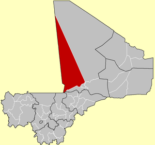
Niafunké Cercle is an administrative subdivision of the Tombouctou Region of Mali. The administrative center (chef-lieu) is the town of Niafunké. In the 2009 census the cercle had a population of 184,285. The Niger River runs for 100 km through the cercle.
Arham is a village and commune of the Cercle of Diré in the Tombouctou Region of Mali.
Garbakoïra is a commune and village of the Cercle of Diré in the Tombouctou Region of Mali. The village lies on the left bank of the left arm of the River Niger, 35 km south west of the town of Timbuktu and 37 km north east of the town of Diré.
Bintagoungou is a rural commune and village of the Cercle of Goudam in the Tombouctou Region of Mali. The village lies at the south east corner of Lake Faguibine near the channel that connects Lake Faguibine to Lake Takara. The commune includes all of Lake Takara and a small section at the eastern end of Lake Faguibine.
Adarmalane also D'adarmalane is a rural commune of the Cercle of Goudam in the Tombouctou Region of Mali. It lies to the south of Lake Faguibine.
Gourma-Rharous or Rharous, is a rural commune and small town in the Timbuktu Region, Mali. The town is the administrative center of the Gourma-Rharous Cercle and lies on the right bank of the Niger River 110 km east of Timbuktu. The commune has an area of approximately 7,000 km2 and contains 29 villages. In the census of 2009 it had a population of 26,115. French singer Daniel Balavoine died in a helicopter crash in Gourma-Rharous as he was leading a fund-raising effort in Africa during the 1986 Dakar Rally.

Bambara Maoudé or Bambara Maoundé is a village and rural commune of the Cercle of Gourma-Rharous in the Tombouctou Region of Mali. The commune contains 44 villages and had a population of 16,874 in the 2009 census.
Banikane is a village and commune of the Cercle of Gourma-Rharous in the Tombouctou Region of Mali. The village lies on the right bank of the River Niger, 25 km downstream of Rharous. The commune extends on both banks of the river and includes 15 villages. In the 2009 census the population of the commune was 9,433.
Koumaïra is a rural commune and village of the Cercle of Niafunké in the Tombouctou Region of Mali. The village is on the south bank of the Bara-Issa, a branch of the Niger River that flows when the river is in flood. It lies 21 km south east of the town of Niafunké and 65 km north east of Lake Debo. The commune contains around 36 small settlements.

Léré is a small town and rural commune of the Cercle of Niafunké in the Tombouctou Region of Mali. The commune covers an area of approximately 1,342 square kilometers and contains the town and 18 villages. In the 2009 census the commune had a population of 16,072.
N'Gorkou is a village and rural commune of the Cercle of Niafunké in the Tombouctou Region of Mali. The commune includes around 54 small settlements.
Soumpi is a village and commune of the Cercle of Niafunké in the Tombouctou Region of Mali. Lac Soumpi is a lake of note here, as is the archaeological site of Tissalaten.
Soboundou is a commune of the Cercle of Niafunké in the Tombouctou Region of Mali. The administrative center (chef-lieu) is the town of Niafunké.
Issa Bery is a commune of the Cercle of Goundam in the Tombouctou Region of Mali. The administrative center (chef-lieu) is the village of Toucabangou which is on the south shore of Lake Faguibine. The commune includes areas of land both to the south and to the north of the lake.
Télé is a rural commune of the Cercle of Goundam in the Tombouctou Region of Mali. The administrative center (chef-lieu) is the village of Hangabéra. The village lies to the east of Lake Télé and 20 km north of the small town of Goundam. Lake Télé is connected to the Niger River by a system of channels. When the river floods in September water flows into the southern end of the lake. Lake Télé is connected at its northern end to Lake Takara. The river water flows out of Lake Takara, across a rocky sill at Kamaïna and eventually reaches Lake Faguibine.

