Torreon, Torrance County, New Mexico

Last updated

Torreon, New Mexico
CDP
NM 55, Torreon NM.jpg
New Mexico State Road 55
Torrance County New Mexico Incorporated and Unincorporated areas Torreon Highlighted.svg
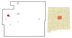
Location of Torreon in Torrance County, New Mexico
Usa edcp location map.svg
Red pog.svg
Torreon, New Mexico
Location in the United States
Coordinates: 34°43′27″N106°18′03″W / 34.72417°N 106.30083°W / 34.72417; -106.30083
Country United States
State New Mexico
Elevation
[1]
6,700 ft (2,000 m)
Time zone Mountain (MST)
GNIS feature ID2409339 [1]

Torreon is a farming community [2] and census-designated place (CDP) in Torrance County, New Mexico, United States. The population was 244 at the 2000 census. It is part of the Albuquerque Metropolitan Statistical Area.

Contents

Geography

Torreon is located on NM State Route 55 on the eastern slopes of the Manzano Mountains.

According to the United States Census Bureau, the CDP has a total area of 8.3 square miles (21.5 km2), all land.

History

Torreon is built on the site of an old Piro [2] pueblo one of the more northern of the Salinas pueblos. [2] The Piro site was occupied prior to the arrival of the Spanish in the 16th century, but became part of the Salinas District, a group of mission towns on the east side of the Manzano Mountains. As the Apache moved south along the edge of the Rocky Mountains in the mid-17th century these missions had to become more defensible. However, by 1677 the Torreon site had been abandoned. Iis had a population of 187 at the 2020 sensus.

Torreon was resettled in the Spring of 1841 by Nino Antonio Montoya and twenty-six other farmers under a grant from the Prefect of the Central District of New Mexico. [2] The Torreon Grant was named after the defensive towers [3] built at Manzano 6.6 miles to the south, and consisted of an area approximately three miles east–west by six miles north–south. Apache raids remained a serious problem until after the Civil War and the appointment of Edward Hatch as New Mexico Military District commander.

Demographics

As of the census [4] of 2000, there were 244 people, 93 households, and 66 families residing in the CDP. The population density was 29.3 inhabitants per square mile (11.3/km2). There were 139 housing units at an average density of 16.7 per square mile (6.5/km2). The racial makeup of the CDP was 73.77% White, 0.41% Native American, 0.82% Asian, 1.23% Pacific Islander, 18.85% from other races, and 4.92% from two or more races. Hispanic or Latino of any race were 68.85% of the population.

There were 93 households, out of which 30.1% had children under the age of 18 living with them, 55.9% were married couples living together, 7.5% had a female householder with no husband present, and 29.0% were non-families. 26.9% of all households were made up of individuals, and 10.8% had someone living alone who was 65 years of age or older. The average household size was 2.62 and the average family size was 3.23.

In the CDP, the population was spread out, with 25.0% under the age of 18, 9.0% from 18 to 24, 20.1% from 25 to 44, 32.0% from 45 to 64, and 13.9% who were 65 years of age or older. The median age was 40 years. For every 100 females, there were 106.8 males. For every 100 females age 18 and over, there were 101.1 males.

The median income for a household in the CDP was $36,250, and the median income for a family was $45,750. Males had a median income of $35,375 versus $12,188 for females. The per capita income for the CDP was $12,349. About 12.9% of families and 10.9% of the population were below the poverty line, including 13.4% of those under the age of eighteen and none of those 65 or over.

See also

Related Research Articles

<span class="mw-page-title-main">Torrance County, New Mexico</span> County in New Mexico, United States

Torrance County is a county located in the center of the U.S. state of New Mexico. As of the 2020 census, the population was 15,045. The county seat is Estancia.

<span class="mw-page-title-main">Sandoval County, New Mexico</span> County in New Mexico, United States

Sandoval County is located in the U.S. state of New Mexico. As of the 2020 census, the population was 148,834, making it the fourth-most populous county in New Mexico. The county seat is Bernalillo.

<span class="mw-page-title-main">Bernalillo County, New Mexico</span> County in New Mexico, United States

Bernalillo County is the most populous county in the U.S. state of New Mexico. As of the 2020 census, the population was 676,444. The county seat, Albuquerque, is the most populous city in New Mexico.

<span class="mw-page-title-main">Carnuel, New Mexico</span> Census-designated place in New Mexico, United States

Carnuel is a census-designated place (CDP) in Bernalillo County, New Mexico, United States. The population was 1,232 at the 2010 Census. It is part of the Albuquerque Metropolitan Statistical Area. Robert Julyan theorizes that name of the community, which has been spelled both Carnuel and Carnué, derives from the Tiwa word for "badger place."

<span class="mw-page-title-main">Isleta Village Proper, New Mexico</span> Census-designated place in New Mexico, United States

Isleta Village Proper is a census-designated place (CDP) in Bernalillo County, New Mexico, United States. The population was 491 at the 2010 census. It is part of the Albuquerque Metropolitan Statistical Area.

<span class="mw-page-title-main">Los Ranchos de Albuquerque, New Mexico</span> Village in New Mexico, United States

Los Ranchos de Albuquerque, known locally simply as "Los Ranchos" or "The Village," is a village in Bernalillo County, New Mexico. The population was 6,024 at the time of the 2010 Census.

<span class="mw-page-title-main">Tijeras, New Mexico</span> Village in New Mexico, United States

Tijeras is a village in Bernalillo County, New Mexico, United States. The population was 541 at the 2010 census. It is part of the Albuquerque metropolitan area.

<span class="mw-page-title-main">Pueblo Pintado, New Mexico</span> CDP in New Mexico, United States

Pueblo Pintado is a census-designated place (CDP) in McKinley County, New Mexico, United States. The population was 247 at the 2000 census.

<span class="mw-page-title-main">Cuba, New Mexico</span> Village in Sandoval County, New Mexico, United States

Cuba is a village in Sandoval County, New Mexico, United States. As of the 2010 census, the village population was 735. It is part of the Albuquerque Metropolitan Statistical Area.

<span class="mw-page-title-main">Pueblo of Sandia Village, New Mexico</span> Village in Sandoval County, New Mexico, US

Pueblo of Sandia Village is a census-designated place (CDP) in Sandoval County, New Mexico, United States. The population was 344 at the 2000 census. It is part of the Albuquerque Metropolitan Statistical Area.

<span class="mw-page-title-main">San Felipe Pueblo, New Mexico</span> CDP in New Mexico, United States

San Felipe Pueblo is a census-designated place (CDP) in Sandoval County, New Mexico, United States, and is located 10 miles (16 km) north of Bernalillo. As of the 2000 census, the CDP population was 2,080. It is part of the Albuquerque Metropolitan Statistical Area.

<span class="mw-page-title-main">Santa Ana Pueblo, New Mexico</span> CDP in New Mexico, United States

Santa Ana Pueblo is a census-designated place (CDP) in Sandoval County, New Mexico, United States. As of the 2000 census, the CDP had a total population of 479. It is part of the Albuquerque Metropolitan Statistical Area. The Pueblo, named Tamaya in Keres, administers a total reservation land of 73,000 acres (295 km2) in the Rio Grande valley and is composed of Native Americans who speak an eastern dialect of the Keresan languages.

<span class="mw-page-title-main">Torreon, Sandoval County, New Mexico</span> Census-designate place in Sandoval County, New Mexico, United States

Torreon is a census-designated place (CDP) in Sandoval County, New Mexico, United States. The population was 297 at the 2000 census. It is part of the Albuquerque Metropolitan Statistical Area.

<span class="mw-page-title-main">Zia Pueblo, New Mexico</span> CDP in New Mexico, United States

Zia Pueblo is a census-designated place (CDP) in Sandoval County, New Mexico, United States. The population was 646 at the 2000 census, with 310 males and 336 females. The pueblo after which the CDP is named is included within the CDP; it is listed on the National Register of Historic Places.

<span class="mw-page-title-main">Socorro, New Mexico</span> City in New Mexico, United States

Socorro is a city in Socorro County in the U.S. state of New Mexico. It is in the Rio Grande Valley at an elevation of 4,579 feet (1,396 m). In 2010 the population was 9,051. It is the county seat of Socorro County. Socorro is located 74 miles (119 km) south of Albuquerque and 146 miles (235 km) north of Las Cruces.

<span class="mw-page-title-main">Manzano, New Mexico</span> CDP in New Mexico, United States

Manzano is a census-designated place (CDP) in Torrance County, New Mexico, United States. The population was 54 at the 2000 census. The Quarai Ruins of Salinas Pueblo Missions National Monument are located near the town. The center of population of New Mexico is located in Manzano.

<span class="mw-page-title-main">Tajique, New Mexico</span> CDP in New Mexico, United States

Tajique is a census-designated place (CDP) in Torrance County, New Mexico, United States. The population was 148 at the 2000 census. It is part of the Albuquerque Metropolitan Statistical Area.

<span class="mw-page-title-main">Albuquerque metropolitan area</span> Metropolitan area in central New Mexico

The Albuquerque Metropolitan Statistical Area, sometimes referred to as Tiguex, is a metropolitan area in central New Mexico centered on the city of Albuquerque. The metro comprises four counties: Bernalillo, Sandoval, Torrance, and Valencia. As of the 2010 United States Census, the MSA had a population of 887,077. The population is estimated to be 923,630 as of July 1, 2020, making Greater Albuquerque the 61st-largest MSA in the nation. The Albuquerque MSA forms a part of the larger Albuquerque–Santa Fe–Las Vegas combined statistical area with a 2020 estimated population of 1,165,181, ranked 49th-largest in the country.

<span class="mw-page-title-main">Mountainair, New Mexico</span> Town in New Mexico, United States

Mountainair is a town in Torrance County, New Mexico, United States. It was founded in 1902 by John Corbett, Colonel E. C. Manning, and Elias S. Stover. The population was 884 at the 2020 census. It is part of the Albuquerque Metropolitan Statistical Area. The main visitor center for Salinas Pueblo Missions National Monument is located within the town.

<span class="mw-page-title-main">Jemez Pueblo, New Mexico</span> CDP in New Mexico, United States

Jemez Pueblo is a census-designated place (CDP) in Sandoval County, New Mexico, United States. The population was 1,788 at the 2010 census. It is part of the Albuquerque Metropolitan Statistical Area.

References

  1. 1 2 U.S. Geological Survey Geographic Names Information System: Torreon, Torrance County, New Mexico
  2. 1 2 3 4 Pearce, T. M. (1965) "Torreon" New Mexico place names; a geographical dictionary University of New Mexico Press, Albuquerque, NM, p. 168, OCLC 420847
  3. Twitchell, Ralph Emerson (1911) The Leading Facts of New Mexican History Torch Press, Cedar Rapids, Iowa, p. 496 OCLC 3828708
  4. "U.S. Census website". United States Census Bureau . Retrieved January 31, 2008.

Commons-logo.svg Media related to Torreon, Torrance County, New Mexico at Wikimedia Commons