
The Eastern Shore is a tourism region of the province of Nova Scotia, Canada. [1] It provides two percent of the revenue for the province's tourism economy. [2] One of its key features is an archipelago known as the 100 Wild Islands area. [3]
The Eastern Shore is a tourism region of the province of Nova Scotia, Canada. [1] It provides two percent of the revenue for the province's tourism economy. [2] One of its key features is an archipelago known as the 100 Wild Islands area. [3]
The list does not include surfing attractions.

Central Nova is a federal electoral district in Nova Scotia, Canada that was represented in the House of Commons of Canada from 1968 until 1996. In 1996, Antigonish County and part of Guysborough County were placed with Pictou County in a new electoral boundaries configuration to form the electoral district of Pictou-Antigonish-Guysborough. A new version of Central Nova was established in 2003 and — in conjunction with the Pictou-Antigonish-Guysborough iteration — represented a significant electoral boundaries change with specific reference to Antigonish County. Between 1867 and 1997, Antigonish County was not in a riding that included Pictou County; rather, it comprised either its own electoral district (Antigonish), or part of other districts shared with Eastern Nova Scotia (Antigonish-Guysborough) and Cape Breton Island communities. In 2013, part of Antigonish County was "placed back" with communities in the electoral district of Cape Breton Canso, a riding which had emerged in part from the former Cape Breton Highlands Canso riding in 1996. The current version of Central Nova includes Pictou County, parts of Antigonish and Guysborough Counties and extends into Halifax Regional Municipality.

Halifax is the capital and largest municipality of the Canadian province of Nova Scotia, and the largest municipality in Atlantic Canada. Halifax is one of Canada's fastest growing municipalities, and as of 2022, it is estimated that the CMA population of Halifax was 480,582, with 348,634 people in its urban area. The regional municipality consists of four former municipalities that were amalgamated in 1996: Halifax, Dartmouth, Bedford, and Halifax County.
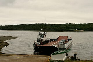
Country Harbour is a rural community in Guysborough County, Nova Scotia, Canada. The community is situated on a large deep natural harbour of the same name and is located along the province's Eastern Shore close to Canso, Nova Scotia.

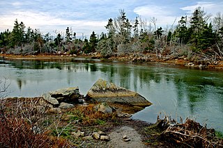
The Eastern Shore is a region of the Canadian province of Nova Scotia. It is the Atlantic coast running northeast from Halifax Harbour to the eastern end of the peninsula at the Strait of Canso.
Area codes 902 and 782 are telephone area codes in the North American Numbering Plan (NANP) for the Canadian provinces of Nova Scotia and Prince Edward Island. Area code 902 was one of the original North American area codes established in October 1947.
Cole Harbour is the name for a natural harbour located in the Canadian province of Nova Scotia.
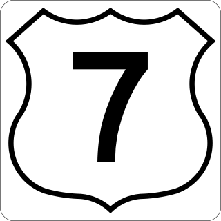
Nova Scotia Trunk 7 is part of the Canadian province of Nova Scotia's system of Trunk Highways. The route runs from Bedford to Antigonish, along the Eastern Shore for a distance of 269 kilometres (167 mi). Part of Trunk 7 is known as the Marine Drive.

Route 207 is a collector road in the Canadian province of Nova Scotia. It is located in the Halifax Regional Municipality and connects Dartmouth to Porters Lake on the Eastern Shore.
The Marine Drive is a designated scenic route along Nova Scotia's Eastern Shore. It closely follows the coast of the Atlantic Ocean and the Strait of Canso from the Canso Causeway to the junction of Route 322 and Highway 111 in Dartmouth.
Route 344 is a collector road in the Canadian province of Nova Scotia.

Musquodoboit Harbour is a rural community located in Nova Scotia, Canada within the Halifax Regional Municipality. The community is situated on the Eastern Shore at the mouth of the Musquodoboit River. The community lies 45 kilometres east of downtown Halifax. With a hospital, RCMP detachment, postal outlet, schools, recreational center, library, municipal office and other services, Musquodoboit Harbour is a serve centre for many of the surrounding communities.

East Chezzetcook is a rural community on the Eastern Shore outside of the Halifax Regional Municipality, Nova Scotia on the East Chezzetcook Road off of Trunk 7. This small French fishing village is home to many descendant Acadians.

Nova Scotia is a province located in Eastern Canada fronting the Atlantic Ocean. One of the Maritime Provinces, Nova Scotia's geography is complex, despite its relatively small size in comparison to other Canadian provinces.

Guysborough, officially named the Municipality of the District of Guysborough, is a district municipality in Guysborough County, Nova Scotia, Canada. Statistics Canada classifies the district municipality as a municipal district.

The following outline is provided as an overview of and topical guide to Nova Scotia:
The Musquodoboit Trailway is a 14.5-kilometre-long (9.0 mi) multiuse rail trail located in Halifax County, Nova Scotia, running the distance from Gibralter to Musquodoboit Harbour. The entire route is part of the Halifax spur of The Great Trail, and follows Nova Scotia Route 357 for its length.