Transport in Samoa

Last updated
Local bus in the capita Apia. Typical bus in Apia, Samoa, 2009.jpg
Local bus in the capita Apia.
Coastal island highway. Samoa coastal road.jpg
Coastal island highway.

Transport in Samoa includes one international airport situated on the north west coast of Upolu island, paved highways reaching most parts of the two main islands, one main port in the capital Apia and two ports servicing mainly inter island ferries for vehicles and passengers between the two main islands, Upolu and Savai'i.

Contents

Highways

Highways:

(2001 est.)

total: 866 km (538 mi)

paved: 350 km (220 mi)

unpaved: 516 km (321 mi)

Ports and harbors

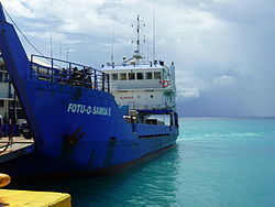
Fotu o Samoa II passenger and cargo ferry operating between Upolu and Savai'i islands. Samoa ferry Fotu o Samoa II.jpg
Fotu o Samoa II passenger and cargo ferry operating between Upolu and Savai'i islands.

Ports and harbors:

Airports

Night departure at Faleolo International Airport Samoa 605.JPG
Night departure at Faleolo International Airport

Airports:

3 (2005)

Airports - with paved runways:

total: 2
2,438 to 3,047 m (7,999 to 9,997 ft): 1 (Apia Faleolo International Airport, IATA airport code APW)

under 914 m (2,999 ft): 1 (2005)

Airports - with unpaved runways:

total: 1

Change from right-hand to left-hand traffic

From 1900 Samoa had been a German colony, and even after the occupation by New Zealand in 1914 it maintained the German practice of driving on the right-hand side of the road. [1] [2]

A plan to move to driving on the left was first announced by the Samoan government in September 2007. Prime Minister Tuilaepa Aiono Sailele Malielegaoi said that the purpose of adopting left-hand traffic was to allow Samoans to use cheaper right-hand-drive vehicles sourced from Australia, New Zealand or Japan, and so that the large number of Samoans living in Australasia could drive on the same side of the road when they visited their country of origin. [3] He aimed to reduce reliance on expensive, left-hand-drive imports from America. [4]

On 18 April 2008 Samoa's parliament passed the Road Transport Reform Act 2008. [5] [6] Tuisugaletaua Avea, the Minister of Transport, announced that the switch would come into effect at 6:00 am on Monday, 7 September 2009 - and that 7 and 8 September 2009 would be public holidays, so that residents would be able to familiarise themselves with the new rules of the road. [7]

However the decision was controversial, with an estimated 18,000 people attending demonstrations against it in Apia in April 2008 and road signs reminding people of the change being vandalised. [8] [9] The motor industry was also opposed to the decision as 14,000 of Samoa's 18,000 vehicles were designed for right-hand driving and the government refused to meet the cost of conversion. [8] Bus drivers whose doors would be on the wrong side of the road due to the change threatened to strike in protest of the change. [10]

In order to reduce accidents, the government widened roads, added new road markings, erected signs and installed speed humps. [4] The speed limit was also reduced from 35 to 25 mph (56 to 40 km/h) and sales of alcohol were banned for three days. [10] Prayers were said by the Congregational Christian Church of Samoa for an accident-free changeover and Samoa's Red Cross carried out a blood donation campaign in case of a surge of accidents. [4] [10]

The change came into force following a radio announcement at 5.50 local time (16:50 UTC) which halted traffic and an announcement at 6.00 (15:00 UTC) for traffic to switch from the right to the left side of the road. [1] Samoa thus became the first territory in over thirty years to change which side of the road is driven on, the previous most recent to change having been Okinawa (1978), South Yemen (1977), Ghana (1974) and Nigeria (1972). [1] [4] [8]

See also

Related Research Articles

Transport in Rwanda

The transport system in Rwanda centres primarily around the road network. Paved roads lie between the capital, Kigali, and most other major cities and towns in the country. Rwanda is also linked by road with other countries in the African Great Lakes, via which the majority of the country's imports and exports are made.

Samoa Polynesian island country

Samoa, officially the Independent State of Samoa and until 1997 known as Western Samoa, is a Polynesian island country consisting of two main islands, two smaller, inhabited islands, and several smaller, uninhabited islands, including the Aleipata Islands. Samoa is located 64 km (40 mi) west of American Samoa, 889 km (552 mi) northeast of Tonga, 1,152 km (716 mi) northeast of Fiji, 483 km (300 mi) east of Wallis and Futuna, 1,151 km (715 mi) southeast of Tuvalu, 519 km (322 mi) south of Tokelau, 4,190 km (2,600 mi) southwest of Hawaii, and 610 km (380 mi)northwest of Niue. The capital city is Apia. The Lapita people discovered and settled the Samoan Islands around 3,500 years ago. They developed a Samoan language and Samoan cultural identity.

Transport in Suriname

The Republic of Suriname has a number of forms of transport. Transportation emissions are an increasing part of Suriname's contributions to climate change, as part of the Nationally Determined Contributions for the Paris Agreement, Suriname has committed to emissions controls for vehicles and increased public transit investment.

Transportation in the United States Virgin Islands

The United States Virgin Islands (USVI) is the only place under United States jurisdiction where the rule of the road is to drive on the left. However, virtually all passenger vehicles are left hand drive due to imports of U.S. vehicles.

Apia Capital of Samoa

Apia is the capital of Samoa, and its only city. It is located on the central north coast of Upolu, Samoa's second-largest island. Apia falls within the political district (itūmālō) of Tuamasaga.

Transport in Anguilla

One of the British overseas territories, the Caribbean island of Anguilla measures only 16 miles (26 km) long by 3 miles (4.8 km) wide, so transport is simpler than in many countries. There is no public transport, such as bus or rail systems, since there isn't enough need. However, Anguilla's roads are better maintained than on many Caribbean islands.

Upolu Island in Samoa

Upolu is an island in Samoa, formed by a massive basaltic shield volcano which rises from the seafloor of the western Pacific Ocean. The island is 75 kilometres long and 1,125 square kilometres in area, making it the second largest of the Samoan Islands by area. With approximately 145,000 inhabitants, it is by far the most populous of the Samoan Islands. Upolu is situated to the southeast of Savai'i, the "big island". Apia, the capital, is in the middle of the north coast, and Faleolo International Airport is at the western end of the island. The island has not had any historically recorded eruptions, although there is evidence of three lava flows, dating back only to between a few hundred and a few thousand years ago.

Left- and right-hand traffic Directionality of traffic flow by jurisdiction

Left-hand traffic (LHT) and right-hand traffic (RHT) are the practices, in bidirectional traffic, of keeping to the left side or to the right side of the road, respectively. They are fundamental to traffic flow, and are sometimes referred to as the rule of the road. The terms right- and left-hand drive refer to the position of the driver and the steering wheel in the vehicle and are the reverse of the terms right- and left-hand traffic. The rule also extends to where on the road a vehicle is to be driven, if there is room for more than one vehicle in the one direction, as well as the side on which the vehicle in the rear overtakes the one in the front. For example, a driver in a LHT country would overtake on the right of the vehicle being overtaken.

Samoan Islands Archipelago in the South Pacific Ocean

The Samoan Islands are an archipelago covering 3,030 km2 (1,170 sq mi) in the central South Pacific, forming part of Polynesia and of the wider region of Oceania. Administratively, the archipelago comprises all of the Independent State of Samoa and most of American Samoa. The land masses of the two Samoan jurisdictions are separated by 64 km (40 mi) of ocean at their closest points.

Mulifanua Village District in Aiga-i-le-Tai, Samoa

Mulifanua is a village on the north-western tip of the island of Upolu, in Samoa. In the modern era, it is the capital of Aiga-i-le-Tai district. Mulifanua wharf is the main ferry terminal for inter-island vehicle and passenger travel across the Apolima Strait between Upolu and the island of Savai'i.

Salelologa Township & Ferry Terminal in Faasaleleaga, Samoa

Salelologa is a village district at the east end of Savai'i island in Samoa. It is the main entry point into the island with the only ferry terminal on Savai'i. It also serves as the main township for shopping and public amenities with a market selling fresh produce and arts and crafts.

Manono Island

Manono is an island of Samoa, situated in the Apolima Strait between the main islands of Savai'i and Upolu, 3.4 km west-northwest off Lefatu Cape, the westernmost point of Upolu.

Aiga-i-le-Tai District in Samoa

Aiga-i-le-Tai is a district of Samoa which includes the small islands of Manono, Apolima and tiny uninhabited Nu'ulopa lying in the Apolima Strait between the country's two main islands of Upolu and Savai'i.

Apolima Strait

The Apolima Strait is about 13 km wide and separates the two largest islands of Samoa: Savai'i to the northwest, and Upolu to the southeast.

Satapuala Village in Aana, Samoa

Satapuala is a village situated on the north west coast Upolu island in Samoa. The village is part of A'ana Alofi 4 Electoral Constituency which forms part of the larger political district A'ana. It has a population of 1963.

Maota Airport

Maota Airport is the main domestic airport on the island of Savai'i in Samoa. It is situated near Salelologa at the east end of Savai'i. The airport is located 10 minutes south of Salelologa township and ferry terminal. The airport has been in operation since the early 1990s. It was tar-sealed in 1994, and declared a customs port of entry in 1997. In the past, the airport has served flights from Faleolo International Airport on the main island Upolu and Asau Airport at the northwest end of Savai'i, but domestic flights were discontinued before 2000. The airport was refurbished in late 2020, and Samoa Airways resumed domestic flights in September that year.

Patamea Village in Gagaemauga, Samoa

Patamea is a village on the island of Savai'i in Samoa. While most villages on Savai'i are situated near the sea, Patamea is situated inland, away from the coast. The village is in the Gaga'emauga political district near the central north coast of the island. The population is 649.

Archaeology of Samoa

Archaeology of Samoa began with the first systematic survey of archaeological remains on Savai'i island by Jack Golson in 1957. Since then, surveys and studies in the rest of Samoa have uncovered major findings of settlements, stone and earth mounds including star mounds, Lapita pottery remains and pre-historic artifacts.

Piula Cave Pool

Piula Cave Pool is a natural freshwater pool by the sea beneath the historic Methodist Chapel at Piula on the north coast of Upolu island in Samoa. It is situated at Lufilufi in the political district of Atua, 26 km east from the capital Apia, along the scenic coastal road. Entry is by the main road through the painted stone wall of Piula Theological College with steps leading down to the pool.

The Samoa Public Library, also known as the Nelson Memorial Public Library, is the main public library in Samoa.

References

  1. 1 2 3 Bryant, Nick (7 September 2009). "Samoan cars ready to switch sides". BBC News. Retrieved 2009-09-07.
  2. Chapman, Paul (8 September 2009). "Samoans jittery over road switch". The Age. Melbourne. Retrieved 2009-09-08.
  3. Samoa Observer: Road switch chaos predicted, Samoa Observer March 26, 2009
  4. 1 2 3 4 "Chaos predicted as Samoa changes driving side". Associated Press. 7 September 2009. Retrieved 2009-09-07.
  5. "Samoan government defeats challenge to road switch plan".
  6. "Samoan prime minister defends decision to switch driving to left side of the road".
  7. Jackson, Cherelle (25 July 2008). "Samoa announces driving switch date". The New Zealand Herald.
  8. 1 2 3 "Outcry as Samoa motorists prepare to drive on left". Reuters. 7 September 2009. Retrieved 2009-09-07.
  9. Dobie, Michael (6 September 2009). "Samoa drivers brace for left turn". BBC News. Retrieved 2009-09-07.
  10. 1 2 3 "Samoan drivers set for shift to the left". AFP. 7 September 2009. Retrieved 2009-09-07.