Cholsey is a village and civil parish 2 miles (3 km) south of Wallingford in South Oxfordshire. In 1974 it was transferred from Berkshire to Oxfordshire, and from Wallingford Rural District to the district of South Oxfordshire. The 2011 Census recorded Cholsey's parish population as 3,457. Cholsey's parish boundaries, some 17 miles (27 km) long, reach from the edge of Wallingford into the Berkshire Downs. The village green is called "The Forty" and has a substantial and ancient walnut tree.

The hundreds of Cornwall were administrative divisions or Shires (hundreds) into which Cornwall, the present day administrative county of England, in the United Kingdom, was divided between c. 925 and 1894, when they were replaced with local government districts.

St Mabyn is a civil parish and village in Cornwall, England, United Kingdom. The village is situated three miles (5 km) east of Wadebridge. The parish includes a hamlet called Longstone to the east and many small manor houses, including Tregarden, Tredethy, Helligan Barton and Colquite, all built in the 16th and 17th centuries. The area of the parish is 4,101 acres (16.60 km2).

Constantine is a village and civil parish in Cornwall, England, United Kingdom. It is situated approximately five miles (8 km) west-southwest of Falmouth. The electoral ward also bears the same name but includes Budock Water and the surrounding area. At the 2011 census, the population of the ward was 4,709 and the population of the civil parish was 1,789. The parish of Constantine is bounded by the parishes of Mabe, Mawnan, Gweek, Wendron and the north bank of the Helford River.

Ruan Lanihorne is a civil parish and village in south Cornwall, England, United Kingdom. The village is situated approximately four miles (6.5 km) east-southeast of Truro between the River Fal and its tributary the Ruan River.

Grade–Ruan is a civil parish on the Lizard peninsula in Cornwall, England, United Kingdom, approximately ten miles (16 km) south of Falmouth.

The hundred of Kerrier was the name of one of ten ancient administrative shires of Cornwall, in the United Kingdom. Kerrier is thought by Charles Thomas to be derived from an obsolete name of Castle Pencaire on Tregonning Hill, Breage. It is likely that an even earlier name for the district was Predannack which has been displaced by the Lizard Peninsula as a geographical name.

St Endellion is a civil parish and hamlet in north Cornwall, England, United Kingdom. The hamlet and parish church are situated four miles (6.5 km) north of Wadebridge.

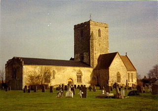
St Wynwallow's Church, Landewednack, is the parish church of Landewednack parish in Cornwall, England, United Kingdom. It is the most southerly church in mainland Britain and is situated approximately ten miles (16 km) south of Helston. It was founded about 600 AD but the present structure dates to the twelfth century.
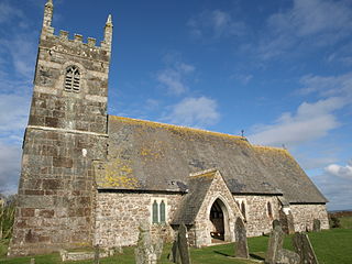
St Grada & Holy Cross Church, Grade is the Church of England parish church of Grade with Ruan, Cornwall. The church is a Grade I listed building, having been added to the listed buildings register on 10 July 1957.
St Ruan is a hamlet in the civil parish of Grade-Ruan, west Cornwall, England, United Kingdom.
Tregullon is a hamlet in the parish of Lanivet near Bodmin in Cornwall, England.

Withielgoose or Withel-goose is a hamlet in Cornwall, England, UK. Withielgoose, from the Cornish gwyth (trees), yel and coes (wood) suggests the clearance of woodland to create agricultural land. The hamlet is accessed via Withielgoose Lane and contains Withielgoose Manor. Withielgoose belongs historically to the parish of Withiel along with Retire and Tregawne; the parish had a total population of about 300 in 1824. It lies about five miles west of Bodmin and six miles east north east of St Columb Major.

Luffincott is a civil parish in the far west of Devon, England. It forms part of the local government district of Torridge and lies about six miles south of the town of Holsworthy. The parish is surrounded clockwise from the north by the parishes of Tetcott, Ashwater, St Giles on the Heath and Northcott. Its western border follows the River Tamar which forms the county boundary with Cornwall.
Webbery is an historic manor in the parish of Alverdiscott in North Devon, England.
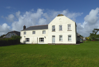
Erisey was a manor on the Lizard Peninsula, Cornwall, UK and is the surname of the family that built the house. The manor was originally in the civil parish of Grade, and since 1934, Grade-Ruan. The Grade II listed building was built by Richard Erisey in the 17th-century and in the 18th-century was owned by the Boscawan family of Tregothnan.

Arrallas was a manorial settlement recorded in the Domesday book, when in 1086 it had seven households and three ploughlands. It is located in the parish of St Enoder in Cornwall, England. Its name derives from the Cornish language words arghans and lys meaning "silver court", with the lys likely denoting a site of royal importance.

Mullion and Grade-Ruan was an electoral division of Cornwall in the United Kingdom which returned one member to sit on Cornwall Council between 2013 and 2021. It was abolished at the 2021 local elections, being succeeded by Mullion and St Keverne.
