Cornwall is a ceremonial county in South West England. It is recognised by Cornish and Celtic political groups as one of the Celtic nations, and is the homeland of the Cornish people. The county is bordered by the Atlantic Ocean to the north and west, Devon to the east, and the English Channel to the south. The largest settlement is Falmouth, and the county town is the city of Truro.

Truro is a cathedral city and civil parish in Cornwall, England, United Kingdom. It is Cornwall's county town, sole city and a centre for administration, leisure and retail trading. Its population was 18,766 in the 2011 census. People of Truro can be called Truronians. It grew as a trade centre through its port and as a stannary town for tin mining. It became mainland Britain's southernmost city in 1876, with the founding of the Diocese of Truro. It is home to Cornwall Council, the Royal Cornwall Museum, Truro Cathedral, the Hall for Cornwall and Cornwall's Courts of Justice.

The Tamar is a river in south west England that forms most of the border between Devon and Cornwall. A part of the Tamar Valley is a World Heritage Site due to its historic mining activities.

The South West Coast Path is England's longest waymarked long-distance footpath and a National Trail. It stretches for 630 miles (1,014 km), running from Minehead in Somerset, along the coasts of Devon and Cornwall, to Poole Harbour in Dorset. Because it rises and falls with every river mouth, it is also one of the more challenging trails. The total height climbed has been calculated to be 114,931 ft (35,031 m), almost four times the height of Mount Everest. It has been voted 'Britain's Best Walking route' twice in a row by readers of The Ramblers' Walk magazine, and regularly features in lists of the world's best walks.

The River Camel is a river in Cornwall, England. It rises on the edge of Bodmin Moor and with its tributaries its catchment area covers much of North Cornwall. The river flows into the eastern Celtic Sea between Stepper Point and Pentire Point having covered about 30 miles, making it the second longest river wholly in Cornwall. The river is tidal upstream to Egloshayle and is popular for sailing, birdwatching and fishing. The name Camel comes from the Cornish language for 'the crooked one', a reference to its winding course. Historically the river was divided into three named stretches. Heyl was the name for the estuary up to Egloshayle, the River Allen was the stretch between Egloshayle and Trecarne, whilst the Camel was reserved for the stretch of river between its source and Trecarne.
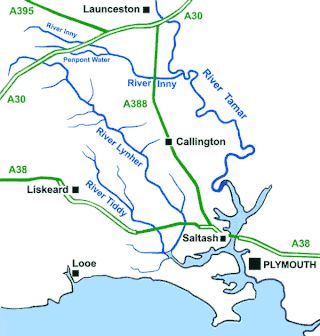
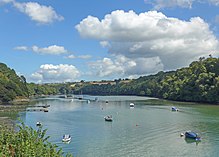
The River Lynher flows through east Cornwall, England, and enters the River Tamar at the Hamoaze, which in turn flows into Plymouth Sound.

The Truro River is a river in the city of Truro in Cornwall, England, UK. It is the product of the convergence of the two rivers named Kenwyn and Allen which run under the city: the Truro River flows into the River Fal, estuarial waters where wildlife is abundant, and then out into the Carrick Roads. The river is navigable up to Truro.

St Columb Major is a town and civil parish in Cornwall, England, United Kingdom. Often referred to locally as St Columb, it is approximately seven miles (11 km) southwest of Wadebridge and six miles (10 km) east of Newquay The designation Major distinguishes it from the nearby settlement and parish of St Columb Minor on the coast. An electoral ward simply named St Columb exists with a population at the 2011 census of 5,050. The town is named after the 6th-century AD Saint Columba of Cornwall, also known as Columb.

Castle an Dinas is an Iron Age hillfort at the summit of Castle Downs near St Columb Major in Cornwall, UK and is considered one of the most important hillforts in the southwest of Britain. It dates from around the 3rd to 2nd century BCE and consists of three ditch and rampart concentric rings, 850 feet (260 m) above sea level. During the early 1960s it was excavated by a team led by Dr Bernard Wailes of the University of Pennsylvania during two seasons of excavation.
Ladock is a village and civil parish in Cornwall, England, United Kingdom. It is about six miles (9.5 km) north-east of Truro.

St Clement is a civil parish and village in Cornwall, England, United Kingdom. It is situated southeast of Truro in the valley of the Tresillian River. Other notable villages within the parish are the much larger Tresillian 1.4 miles (2.3 km) to the north east of St Clement village itself and another village at Malpas to the south of the parish. The urban part of the parish of St Clement was incorporated into Truro in 1895. The remainder of the parish had a population of 1,064 at the 2011 census.

Tresillian is a small village in mid Cornwall, England, United Kingdom. It is three miles (5 km) east of Truro on the A390 road. Tresillian means "a place of eels" in the Cornish language, according to a 19th-century writer. However, modern toponymists agree that the name in fact translates as "farm/settlement of a man called Sulyen".

Withiel is a civil parish and village in mid Cornwall, England, United Kingdom. The parish of Withiel is between the parishes of St Breock, Lanivet, Roche and St Wenn. The name Withiel comes from the Cornish word Gwydhyel, meaning "wooded place". The parish contains the hamlets of Withielgoose, Retire and Tregawne; the parish had a total population of about 300 in 1824.

Merther is a small hamlet and former civil parish, now in the parish of St Michael Penkevil, in the Cornwall district, in the ceremonial county of Cornwall, England. It lies 2 miles (3 km) east of Truro, on the eastern side of the Tresillian River. In 1931 the parish had a population of 150. It was formerly the churchtown of the small parish of Merther, and also the site of a manor house and medieval chapel dedicated to St Cohan. The former parish church is now in ruins.
Malpas is a riverside village, and former port, in the civil parish of St Clement, in Cornwall, England, United Kingdom. It is situated two miles (3 km) southeast of the city of Truro, on the confluence of the Truro River and the Tresillian River.
Bridge is a village in Cornwall, England, United Kingdom. It is in the civil parish of Portreath and lies about 1 km east of Portreath village and harbour. The population of Bridge is not recorded separately in censuses, and makes up a small proportion of the 1,581 living in the parish as a whole.
Roseland was an electoral division of Cornwall in the United Kingdom which returned one member to sit on Cornwall Council between 2009 and 2021. It was abolished at the 2021 local elections, being succeeded by St Goran, Tregony and the Roseland.

St Enoder was an electoral division of Cornwall in the United Kingdom which returned one member to sit on Cornwall Council between 2013 and 2021. It was abolished at the 2021 local elections, being succeeded by St Dennis and St Enoder.

Ladock, St Clement and St Erme was an electoral division of Cornwall in the United Kingdom which returned one member to sit on Cornwall Council between 2009 and 2021. It was abolished at the 2021 local elections, being succeeded by Truro Tregolls, Probus and St Erme, and St Newlyn East, Cubert and Goonhavern.