Triple Divide Peak (Montana)

Last updated
Triple Divide Peak
Triple Divide Peak.jpg
Triple Divide Peak, east aspect
Highest point
Elevation 8,025 ft (2,446 m) [1]
Prominence 180 ft (55 m) [1]
Parent peak Norris Mountain [1]
Listing Mountains in Flathead County
Mountains in Glacier County
Coordinates 48°34′23″N113°31′00″W / 48.57306°N 113.51667°W / 48.57306; -113.51667 [2]
Geography
USA Montana relief location map.jpg
Red triangle with thick white border.svg
Triple Divide Peak
Location in Montana
Usa edcp relief location map.png
Red triangle with thick white border.svg
Triple Divide Peak
Location in the United States
Location Flathead County, Montana, Glacier County, Montana, U.S.
Parent range Lewis Range
Topo map USGS Mount Stimson, MT
A map of North American drainage basins/divides. Triple Divide Peak is noted at the juncture of the primary North American Continental Divide (red) and Laurentian (green) divides. NorthAmerica-WaterDivides.png
A map of North American drainage basins/divides. Triple Divide Peak is noted at the juncture of the primary North American Continental Divide (red) and Laurentian (green) divides.

Triple Divide Peak (8,025 feet or 2,446 metres) is located in the Lewis Range, part of the Rocky Mountains in North America. The peak is a feature of Glacier National Park in the state of Montana in the United States. [3] The summit of the peak, the hydrological apex of the North American continent, is the point where two of the principal continental divides in North America converge, the Continental Divide of the Americas and the Northern or Laurentian Divide.

Contents

Hydrography

Water that falls at the summit can flow either to the Pacific, Atlantic, or Arctic oceans (when Hudson Bay is considered a marginal sea of the Arctic Ocean). The International Hydrographic Organization (in its current unapproved working edition only [4] of Limits of Oceans and Seas) defines the Hudson Bay, with its outlet extending from 62.5 to 66.5 degrees north (just a few miles south of the Arctic Circle) as being part of the Arctic Ocean, specifically "Arctic Ocean Subdivision 9.11."

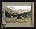
North America is not the only continent with shores on three different oceans. Asia borders the Arctic, Indian, and Pacific Oceans, as well as the Atlantic Ocean if the Mediterranean and Black Seas are considered parts thereof. Also, Antarctica borders the Atlantic, Indian, and Pacific Oceans if the Southern Ocean is not considered a separate ocean from the former three. However, the inward-draining endorheic basins of Central and Western Asia separate all combinations of 3 of the 4 oceans bordering the continent so that no 3 of their basins meet at a single location. In the case of Antarctica, there is no freely flowing water due to ice sheets and permafrost. So Triple Divide Peak is the only single point on Earth from which water flows into three distinct oceans. Some sources consider Hudson Bay to be part of the Atlantic, which would make Snow Dome – partially in Jasper National Park, on the border of the provinces of Alberta and British Columbia, Canada – the world’s sole hydrological apex. [5] [6] [7]

Rainfall on the southwestern side of the peak enters Pacific Creek, which in turn enters Nyack Creek, the Middle Fork of the Flathead River, the Flathead River through Flathead Lake, the Clark Fork River into Pend Oreille Lake, the Pend Oreille River, and the Columbia River which empties into the Pacific near Astoria, Oregon.

The northern slope of the mountain sheds water into Hudson Bay Creek, which then drains into Medicine Owl Creek and Red Eagle Creek. It then empties into Saint Mary Lake, which feeds the St. Mary River, which in turn flows into the Oldman River, the South Saskatchewan River, the Saskatchewan River, and the Lake Winnipeg system, drained by the Nelson River which empties into Hudson Bay.

Moisture on the southeastern slopes feeds into Atlantic Creek, which in turn enters the North Fork of Cut Bank Creek, Cut Bank Creek, the Marias River, and the Missouri River which joins the Mississippi River before emptying into the Atlantic's Gulf of Mexico near New Orleans.

Geology

The Lewis Range was formed in the Lewis Overthrust, some 59-75 million years ago, when an enormous slab of Precambrian rock faulted and slid over younger rocks from the Cretaceous period.

See also

Related Research Articles

<span class="mw-page-title-main">Geography of Canada</span>

Canada has a vast geography that occupies much of the continent of North America, sharing a land border with the contiguous United States to the south and the U.S. state of Alaska to the northwest. Canada stretches from the Atlantic Ocean in the east to the Pacific Ocean in the west; to the north lies the Arctic Ocean. Greenland is to the northeast with a shared border on Hans Island. To the southeast Canada shares a maritime boundary with France's overseas collectivity of Saint Pierre and Miquelon, the last vestige of New France. By total area, Canada is the second-largest country in the world, after Russia. By land area alone, however, Canada ranks fourth, the difference being due to it having the world's largest proportion of fresh water lakes. Of Canada's thirteen provinces and territories, only two are landlocked while the other eleven all directly border one of three oceans.

<span class="mw-page-title-main">Continental Divide of the Americas</span> Principal hydrological divide of North and South America

The Continental Divide of the Americas is the principal, and largely mountainous, hydrological divide of the Americas. The Continental Divide extends from the Bering Strait to the Strait of Magellan, and separates the watersheds that drain into the Pacific Ocean from those river systems that drain into the Atlantic and Arctic Ocean, including those that drain into the Gulf of Mexico, the Caribbean Sea, and Hudson Bay.

<span class="mw-page-title-main">Canadian Rockies</span> Mountain range in Canada

The Canadian Rockies or Canadian Rocky Mountains, comprising both the Alberta Rockies and the British Columbian Rockies, is the Canadian segment of the North American Rocky Mountains. It is the easternmost part of the Canadian Cordillera, which is the northern segment of the North American Cordillera, the expansive system of interconnected mountain ranges between the Interior Plains and the Pacific Coast that runs northwest–southeast from central Alaska to the Isthmus of Tehuantepec in Mexico.

<span class="mw-page-title-main">Glacial Lake Missoula</span> Prehistoric proglacial lake in Western Montana

Lake Missoula was a prehistoric proglacial lake in western Montana that existed periodically at the end of the last ice age between 15,000 and 13,000 years ago. The lake measured about 7,770 square kilometres (3,000 sq mi) and contained about 2,100 cubic kilometres (500 cu mi) of water, half the volume of Lake Michigan.

<span class="mw-page-title-main">Clark Fork River</span> River in the U.S. states of Montana and Idaho

The Clark Fork, or the Clark Fork of the Columbia River, is a river in the U.S. states of Montana and Idaho, approximately 310 miles (500 km) long. The largest river by volume in Montana, it drains an extensive region of the Rocky Mountains in western Montana and northern Idaho in the watershed of the Columbia River. The river flows northwest through a long valley at the base of the Cabinet Mountains and empties into Lake Pend Oreille in the Idaho Panhandle. The Pend Oreille River in Idaho, Washington, and British Columbia, Canada which drains the lake to the Columbia in Washington, is sometimes included as part of the Clark Fork, giving it a total length of 479 miles (771 km), with a drainage area of 25,820 square miles (66,900 km2). In its upper 20 miles (32 km) in Montana near Butte, it is known as Silver Bow Creek. Interstate 90 follows much of the upper course of the river from Butte to Saint Regis. The highest point within the river's watershed is Mount Evans at 10,641 feet (3,243 m) in Deer Lodge County, Montana along the Continental Divide.

<span class="mw-page-title-main">Pend Oreille River</span> River, tributary of the Columbia

The Pend Oreille River is a tributary of the Columbia River, approximately 130 miles (209 km) long, in northern Idaho and northeastern Washington in the United States, as well as southeastern British Columbia in Canada. In its passage through British Columbia its name is spelled Pend-d'Oreille River. It drains a scenic area of the Rocky Mountains along the U.S.-Canada border on the east side of the Columbia. The river is sometimes defined as the lower part of the Clark Fork, which rises in western Montana. The river drains an area of 66,800 square kilometres (25,792 sq mi), mostly through the Clark Fork and its tributaries in western Montana and including a portion of the Flathead River in southeastern British Columbia. The full drainage basin of the river and its tributaries accounts for 43% of the entire Columbia River Basin above the confluence with the Columbia. The total area of the Pend Oreille basin is just under 10% of the entire 258,000-square-mile (670,000 km2) Columbia Basin. Box Canyon Dam is currently underway on a multimillion-dollar project for a fish ladder.

<span class="mw-page-title-main">Kootenay River</span> River in Western Canada and the United States

The Kootenay River or Kootenai River is a major river of the Northwest Plateau in southeastern British Columbia, Canada, and northern Montana and Idaho in the United States. It is one of the uppermost major tributaries of the Columbia River, the largest North American river that empties into the Pacific Ocean. The Kootenay River runs 781 kilometres (485 mi) from its headwaters in the Kootenay Ranges of the Canadian Rockies, flowing from British Columbia's East Kootenay region into northwestern Montana, then west into the northernmost Idaho Panhandle and returning to British Columbia in the West Kootenay region, where it joins the Columbia at Castlegar.

<span class="mw-page-title-main">Flathead River</span> River in Montana, United States

The Flathead River, in the northwestern part of the U.S. state of Montana, originates in the Canadian Rockies to the north of Glacier National Park and flows southwest into Flathead Lake, then after a journey of 158 miles (254 km), empties into the Clark Fork. The river is part of the Columbia River drainage basin, as the Clark Fork is a tributary of the Pend Oreille River, a Columbia River tributary. With a drainage basin extending over 8,795 square miles (22,780 km2) and an average discharge of 11,380 cubic feet per second (322 m3/s), the Flathead is the largest tributary of the Clark Fork and constitutes over half of its flow.

<span class="mw-page-title-main">Snow Dome (Canada)</span> Mountain on the border of Alberta and British Columbia, Canada

Snow Dome is a mountain located on the Continental Divide in the Columbia Icefield, where the boundary of Banff National Park and Jasper National Park meets the border of Alberta and British Columbia in Canada. The summit's elevation is 3,456 m (11,339 ft).

<span class="mw-page-title-main">Laurentian Divide</span> Hydrological divide in North America

The Laurentian Divide also called the Northern Divide and locally the height of land, is a continental divide in central North America that separates the Hudson Bay watershed to the north from the Gulf of Mexico watershed to the south and the Great Lakes-St. Lawrence watershed to the southeast.

<span class="mw-page-title-main">Continental divide</span> Drainage divide on a continent

A continental divide is a drainage divide on a continent such that the drainage basin on one side of the divide feeds into one ocean or sea, and the basin on the other side either feeds into a different ocean or sea, or else is endorheic, not connected to the open sea. Every continent on earth except Antarctica has at least one continental drainage divide; islands, even small ones like Killiniq Island on the Labrador Sea in Canada, may also host part of a continental divide or have their own island-spanning divide. The endpoints of a continental divide may be coastlines of gulfs, seas or oceans, the boundary of an endorheic basin, or another continental divide. One case, the Great Basin Divide, is a closed loop around an endorheic basin. The endpoints where a continental divide meets the coast are not always definite since the exact border between adjacent bodies of water is usually not clearly defined. The International Hydrographic Organization's publication Limits of Oceans and Seas defines exact boundaries of oceans, but it is not universally recognized. Where a continental divide meets an endorheic basin, such as the Great Divide Basin of Wyoming, the continental divide splits and encircles the basin. Where two divides intersect, they form a triple divide, or a tripoint, a junction where three watersheds meet.

<span class="mw-page-title-main">Geography of Montana</span> Overview of the Geography of Montana

Montana is one of the eight Mountain States, located in the north of the region known as the Western United States. It borders North Dakota and South Dakota to the east. Wyoming is to the south, Idaho is to the west and southwest, and the Canadian provinces of British Columbia, Alberta, and Saskatchewan are to the north, making it the only state to border three Canadian provinces.

<span class="mw-page-title-main">North Fork Flathead River</span> River in Canada, United States

The North Fork Flathead River is a 153-mile (246 km) river flowing through British Columbia, Canada, south into the U.S. state of Montana. It is one of the three primary forks of the Flathead River, the main inflow of Flathead Lake and a tributary of the Columbia River via the Clark Fork River and the Pend Oreille River. The river is sometimes considered the upper headwaters of the Flathead River, although the North Fork is its official name in the U.S. Other naming conventions for the river include Flathead River - North Fork, North Fork of Flathead River, and North Fork of the Flathead River.

<span class="mw-page-title-main">Middle Fork Flathead River</span> River in Montana, United States

The Middle Fork Flathead River is a 92-mile (148 km) river in western Montana in the United States, forming the southwestern boundary of Glacier National Park. Its drainage basin lies to the east of the South Fork Flathead River and the Hungry Horse Reservoir. Towns along the river include West Glacier, Nyack, Pinnacle, Essex, and Nimrod.

<span class="mw-page-title-main">South Fork Flathead River</span> River in Montana, United States

The South Fork Flathead River is a major river in Northwestern Montana in the northwest United States. It is one of the three main forks of the Flathead River, a tributary of the Clark Fork River. The north-northwest trending river is about 98 miles (158 km) long, making it the second longest tributary of the Flathead River.

<span class="mw-page-title-main">Swan Range</span> Mountain range in Montana, United States

The Swan Range is a mountain range in western Montana in the United States. Its peaks typically rise to around 8,000 to 9,000 feet. The range is bounded by the South Fork Flathead River to the east, the Flathead River to the north and northwest, the Swan River to the west, and lie to the southwest of Glacier National Park, just south of the Canada–US border. It runs about 99 miles (159 km) from north-northwest to south-southeast. Major cities near the Swan Range include Kalispell and Bigfork to the northwest, and Seeley Lake on the south.

<span class="mw-page-title-main">Lake bifurcation</span> Lake that flows into two drainage basins

A lake bifurcation occurs when a lake has outflows into two different drainage basins. In this case, the drainage divide cannot be defined exactly, as it is situated in the middle of the lake.

<span class="mw-page-title-main">Watersheds of North America</span>

Watersheds of North America are large drainage basins which drain to separate oceans, seas, gulfs, or endorheic basins. There are six generally recognized hydrological continental divides which divide the continent into seven principal drainage basins spanning three oceans and one endorheic basin. The basins are the Atlantic Seaboard basin, the Gulf of Mexico basin, the Great Lakes-St. Lawrence basin, the Pacific basin, the Arctic basin, the Hudson Bay basin, and the Great Basin. Together, the principal basins span the continent with the exception of numerous smaller endorheic basins.

<span class="mw-page-title-main">Triple divide</span> Point where three drainage basins meet

A triple divide or triple watershed is a point on Earth's surface where three drainage basins meet. A triple divide results from the intersection of two drainage divides. Triple divides range from prominent mountain peaks to minor side peaks, down to simple slope changes on a ridge which are otherwise unremarkable. The elevation of a triple divide can be thousands of meters to barely above sea level. Triple divides are a common hydrographic feature of any terrain that has rivers, streams and/or lakes.

References

  1. 1 2 3 "Triple Divide Peak, Montana". Peakbagger.com. Retrieved 2010-08-22.
  2. "Triple Divide Peak". Geographic Names Information System . United States Geological Survey, United States Department of the Interior . Retrieved 2010-08-22.
  3. "Triple Divide Peak, Montana" (Map). TopoQuest (USGS Quad). Retrieved 2010-08-22.
  4. "IHO Publication S-23 Limits of Oceans and Seas; Chapter 9: Arctic Ocean". International Hydrographic Organization. 2002. Retrieved 2017-07-01.
  5. Sanford, Robert W. (2010). Our World's Heritage: Creating a Culture Worthy of Place in Canada's Western Mountain Parks. Athabasca University Press. p. 160. ISBN   978-1-897425-57-2.
  6. Canada's watersheds, The Canadian Atlas Online
  7. The North Saskatchewan River Archived 2010-05-26 at the Wayback Machine , Great Canadian Rivers
  8. Holtz, Mathilde Edith; Bemis, Katharine Isabel (1917). Glacier National Park: Its Trails and Treasures (PDF). New York: George H. Doran.