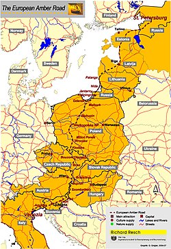
The Amber Road was an ancient trade route for the transfer of amber from coastal areas of the North Sea and the Baltic Sea to the Mediterranean Sea. Prehistoric trade routes between Northern and Southern Europe were defined by the amber trade.

Elbląg is a city in the Warmian-Masurian Voivodeship, in northern Poland, located in the eastern edge of the Żuławy region with 127,390 inhabitants, as of December 2021. It is the capital of Elbląg County.

Hedeby was an important Danish Viking Age trading settlement near the southern end of the Jutland Peninsula, now in the Schleswig-Flensburg district of Schleswig-Holstein, Germany. Around 965, chronicler Abraham ben Jacob visited Hedeby and described it as, "a very large city at the very end of the world's ocean."

Sambia or Samland or Kaliningrad Peninsula is a peninsula in the Kaliningrad Oblast of Russia, on the southeastern shore of the Baltic Sea. The peninsula is bounded by the Curonian Lagoon to the north-east, the Vistula Lagoon in the southwest, the Pregolya River in the south, and the Deyma River in the east. As Sambia is surrounded on all sides by water, it is technically an island. Historically it formed an important part of the historic region of Prussia.
Wulfstan of Hedeby was a late ninth-century traveller and trader. His travel accounts, as well as those of another trader, Ohthere of Hålogaland, were included in the Old English Orosius. It is unclear if Wulfstan was English or indeed if he was from Hedeby, in what is now northern Germany near the city of Schleswig but in the 9th century was Danish.

The Vistula Spit is an aeolian sand spit, or peninsular stretch of land, separating Vistula Lagoon from Gdańsk Bay, in the Baltic Sea, with its tip separated from the mainland by the Strait of Baltiysk. The border between Poland and Kaliningrad Oblast, an exclave of Russia, bisects it, politically dividing the spit into two pieces between the two countries. The westernmost geographical point of Russia is located on the Vistula Spit. The Polish part contains a number of tourist resorts, incorporated administratively as the town of Krynica Morska.

Old Prussians, Baltic Prussians or simply Prussians were a Baltic people that inhabited the region of Prussia, on the southeastern shore of the Baltic Sea between the Vistula Lagoon to the west and the Curonian Lagoon to the east. As Balts, they spoke an Indo-European language of the Baltic branch now known as Old Prussian and worshipped pre-Christian deities. Their ethnonym was later adopted by predominantly Low German-speaking inhabitants of the region.

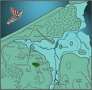
Drużno is a body of water historically considered a lake in northern Poland on the east side of the Vistula delta, near the city of Elbląg. As it is currently not deep enough to qualify as a lake hydrologically and receives some periodic inflow of sea water from the Vistula Lagoon along the Elbląg River, some suggest that it be termed an estuary reservoir. A village of recent origin also called Drużno is situated near the lake.

The Aesti were an ancient people first described by the Roman historian Tacitus in his treatise Germania. According to Tacitus, the territory of Aesti was located somewhere east of the Suiones (Swedes).

The Battle of Vistula Lagoon was fought on September 15, 1463 between the navy of the Teutonic Order, and the navy of the Prussian Confederation which was allied with the King of Poland, as part of the Thirteen Years' War. The battle was the largest naval battle of the war, and one of the two battles which decided the final outcome of the war.

The Elbląg is a 14.5-kilometre (9.0 mi) river in northern Poland connecting Lake Drużno with the Vistula Lagoon. The eponymous city of Elbląg is situated on the river. The tributaries of the Elbląg include the Fiszewka, Kumiela and Tina.
The most important phenomenon that took place within the lands of Poland in the Early Middle Ages, as well as other parts of Central Europe was the arrival and permanent settlement of the West Slavic or Lechitic peoples. The Slavic migrations to the area of contemporary Poland started in the second half of the 5th century AD, about a half century after these territories were vacated by Germanic tribes fleeing from the Huns. The first waves of the incoming Slavs settled the vicinity of the upper Vistula River and elsewhere in the lands of present southeastern Poland and southern Masovia. Coming from the east, from the upper and middle regions of the Dnieper River, the immigrants would have had come primarily from the western branch of the early Slavs known as Sclaveni, and since their arrival are classified as West Slavs and Lechites, who are the closest ancestors of Poles.[a]

Żuławy Wiślane, in English known as the Vistula Fens, is the alluvial delta area of the river Vistula, in the northern part of Poland. It is a flat and deforested region comprising wetlands and agricultural plains that cover approximately 1,700 squared kilometres, with much of the land being situated below sea level. Poland's lowest point is located at Raczki Elbląskie in the Żuławy region.
Janów is a village in the administrative district of Gmina Elbląg, within Elbląg County, Warmian-Masurian Voivodeship, in northern Poland. It lies approximately 6 kilometres (4 mi) east of Elbląg and 76 km (47 mi) north-west of the regional capital Olsztyn.

The Vistula is the longest river in Poland and the ninth-longest in Europe, at 1,047 kilometres in length. Its drainage basin, extending into three other countries apart from Poland, covers 193,960 km2 (74,890 sq mi), of which 168,868 km2 (65,200 sq mi) is in Poland.
The Vistula Lagoon is a brackish water lagoon on the Baltic Sea roughly 56 miles (90 km) long, 6 to 15 miles wide, and up to 17 feet (5 m) deep, separated from the Gdańsk Bay by the Vistula Spit.
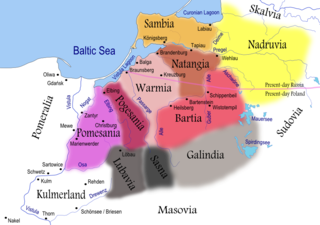
Pomesanians were a Prussian clan. They lived in Pomesania, a historical region in modern northern Poland, located between the Nogat and Vistula Rivers to the west and the Elbląg River to the east. It is located around the modern towns of Elbląg and Malbork. As the westernmost clan, the Pomesanians were the first of the Prussians to be conquered by the Teutonic Knights, a German military crusading order brought to the Chełmno Land to convert the pagans to Christianity. Due to Germanization and assimilation, Pomesanians became extinct some time in the 17th century.

While the Vikings are perhaps best known for accumulating wealth by plunder, tribute, and conquest, they were also skilled and successful traders. The Vikings developed several trading centres both in Scandinavia and abroad as well as a series of long-distance trading routes during the Viking Age. Viking trading centres and trade routes would bring tremendous wealth and plenty of exotic goods such as Arab coins, Chinese Silks, and Indian Gems. Vikings also established a "bullion economy" in which weighed silver, and to a lesser extent gold, was used as a means of exchange. Evidence for the centrality of trade and economy can be found in the criminal archaeological record through evidence of theft, counterfeit coins, and smuggling. The Viking economy and trade network also effectively helped rebuild the European economy after the fall of the Roman Empire

Witland is a seldom-used name for a historical region in the south-east Baltic region inhabited by Prussians (Aestii), called Estum in the text of Wulfstan. The name appears in King Alfred's adapted version of Orosius, in which the traveller Wulfstan's accounts were incorporated.
Kaup is a hill on the bank of the Curonian Lagoon, immediately north of the village of Mokhovoye, Kaliningrad Oblast, Russia. It is a large early medieval burial site with Norse grave goods. Kaup has been viewed by historians as an important early medieval emporium and a likely starting point of the Amber Road to the south. The original name of this medieval settlement is uncertain.