Tudor and Cashel

Last updated

Tudor and Cashel
Township of Tudor and Cashel
Tudor-Cashel Twp.JPG
Municipal office in Gilmour
Canada Southern Ontario location map 2.png
Red pog.svg
Tudor and Cashel
Coordinates: 44°45′N77°36′W / 44.750°N 77.600°W / 44.750; -77.600
Country Canada
Province Ontario
County Hastings
Incorporated1869
Government
  TypeTownship under a mayoral-council system
  MayorDave Hederson
  Deputy mayorRonald Carroll
  Federal riding Hastings—Lennox and Addington
  Prov. riding Hastings—Lennox and Addington
Area
[1]
  Land445.66 km2 (172.07 sq mi)
Population
 (2016) [1]
  Total586
  Density1.3/km2 (3/sq mi)
Time zone UTC-5 (EST)
  Summer (DST) UTC-4 (EDT)
Postal Code
K0L 1W0
Area code(s) 613 and 343
Website www.tudorandcashel.com OOjs UI icon edit-ltr-progressive.svg

Tudor and Cashel is a township in the Canadian province of Ontario, located in Hastings County.

Contents

The township consists of two non-contiguous portions, separated by Limerick township and the northernmost portion of Tweed.The municipality is mostly rural.

History

Tudor Township was created circa 1865. [2] Cashel Township was created circa 1869. [3] Tudor and Cashel Townships were administered as one in 1897. [4]

Limerick Township and Wollaston Township petitioned unsuccessfully for separation from Tudor Township in 1868. [5] Wollaston Township was eventually formed circa 1880. Limerick Township was eventually formed in 1887 between today's Tudor and Cashel Townships. Geologically Limerick Township and Tudor Township are very similar, with valuable mineral resources. [6]

After the separation of old Limerick Township, the townships of Tudor and Cashel were geographically separated since Limerick abutted along a corner of old Grimsthorpe Township (which was later amalgamated into the Municipality of Tweed).

Communities

Millbridge Station Millbridge Stn ON.JPG
Millbridge Station

Demographics

In the 2021 Census of Population conducted by Statistics Canada, Tudor and Cashel had a population of 740 living in 352 of its 758 total private dwellings, a change of 26.3% from its 2016 population of 586. With a land area of 433.31 km2 (167.30 sq mi), it had a population density of 1.7/km2 (4.4/sq mi) in 2021. [8]

Canada census – Tudor and Cashel community profile
2016 2011
Population586 (0.0% from 2011)586 (-14.1% from 2006)
Land area445.66 km2 (172.07 sq mi)445.67 km2 (172.07 sq mi)
Population density1.3/km2 (3.4/sq mi)1.3/km2 (3.4/sq mi)
Median age53.0 (M: 52.3, F: 53.7)
Private dwellings768 (total) 675 (total) 
Median household income$45,952
References: 2016 [9] 2011 [10] earlier [11] [12]
Historical census populations
YearPop.±%
1976 522    
1981 481−7.9%
1986 483+0.4%
1991 591+22.4%
1996 696+17.8%
YearPop.±%
2001 665−4.5%
2006 682+2.6%
2011 586−14.1%
2016 586+0.0%
Source: Statistics Canada [13] [14] [1]

Mother tongue: [11]

See also

Related Research Articles

<span class="mw-page-title-main">Hastings County</span> County in Ontario, Canada

Hastings County is located in the province of Ontario, Canada. Geographically, it is located on the border of Eastern Ontario and Central Ontario. Hastings County is the second-largest county in Ontario, after Renfrew County, and its county seat is Belleville, which is independent of Hastings County. Hastings County has trademarked the moniker "Cheese Capital of Canada".

<span class="mw-page-title-main">Tweed, Ontario</span> Municipality in Ontario, Canada

Tweed is a municipality located in central-eastern Ontario, Canada, in Hastings County.

<span class="mw-page-title-main">Central Frontenac</span> Township in Ontario, Canada

Central Frontenac is a township in eastern Ontario, Canada in the County of Frontenac.

<span class="mw-page-title-main">Centre Hastings</span> Municipality in Ontario, Canada

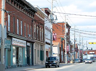
The Municipality of Centre Hastings is a township in Eastern Ontario, Canada, in Hastings County. It was formed on January 1, 1998, through the amalgamation of Huntingdon Township with the Village of Madoc.

<span class="mw-page-title-main">Prince Edward—Hastings</span> Federal electoral district in Ontario, Canada

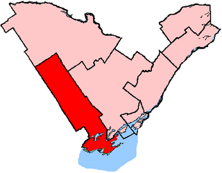
Prince Edward—Hastings was a federal electoral district in Ontario, Canada, that existed in the House of Commons of Canada from 1968 to 2015. Its population in 2006 was 113,227. It was redistributed between Bay of Quinte electoral district and Hastings—Lennox and Addington electoral district as a result of the Canadian federal electoral redistribution, 2012.

<span class="mw-page-title-main">Quinte West</span> City in Ontario, Canada

Quinte West is a city, geographically located in but administratively separated from Hastings County, in Southern Ontario, Canada. It is on the western end of the Bay of Quinte on Lake Ontario. The Lake Ontario terminus of the Trent–Severn Waterway is in the municipality.

<span class="mw-page-title-main">Moira River</span> River in Ontario, Canada

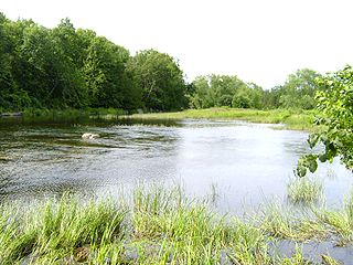
The Moira River is a river in Hastings County in eastern Ontario, Canada. It travels from its source in the centre of the county to the Bay of Quinte at the county seat Belleville.

<span class="mw-page-title-main">Madoc, Ontario (village)</span>

Madoc is a community in the municipality of Centre Hastings, Hastings County, Ontario, Canada. It is located at the junction of Highway 7 and Highway 62, southeast of Bancroft, halfway between Toronto and Ottawa.

Hastings was a federal electoral district represented in the House of Commons of Canada from 1968 to 1979. It was located in the province of Ontario. This riding was created in 1966 from parts of Hastings South and Hastings—Frontenac ridings.

<span class="mw-page-title-main">Limerick, Ontario</span> Township in Ontario, Canada

Limerick is a small township in Hastings County, Ontario, Canada, near Limerick Lake. It is located 80 kilometres (50 mi) north of Belleville between Madoc and Bancroft and served by Ontario Highway 62 and Township Road 620. The Township is bordered by the Town of Bancroft, Township of Wollaston and the joined Townships of Tudor and Cashel. The township is heavily forested, as is the shoreline of the Limerick Lake, the main industry in the township being forestry and logging. The population of Limerick Township is approx. 300 full-year residents, and another 1000 seasonal residents.

<span class="mw-page-title-main">Stirling-Rawdon</span> Township in Ontario, Canada

Stirling-Rawdon is a township in the Canadian province of Ontario, located in Hastings County. It was formed on January 1, 1998, through the amalgamation of Rawdon Township with the Village of Stirling. Stirling was named the 2012 Kraft Hockeyville winner, after gaining more than 3.9 million votes.

King's Highway 62, commonly referred to as Highway 62, is a provincially maintained highway in the Canadian province of Ontario. The highway travels south–north from Highway 33 at Bloomfield in Prince Edward County, through Belleville, Madoc and Bancroft, to Maynooth, where it ends at a junction with Highway 127. Prior to 1997, the route continued north and east of Maynooth through Cobermere, Barry's Bay, Killaloe, Round Lake and Bonnechere to Highway 17 in Pembroke. This section of highway was redesignated Hastings Highlands Municipal Road 62, Renfrew County Road 62, and Renfrew County Road 58.

<span class="mw-page-title-main">Stone Mills</span> Township in Ontario, Canada

Stone Mills is a lower-tier township north of Greater Napanee in Lennox and Addington County, Ontario, Canada. According to the 2016 census, the township has a population of 7,702.

<span class="mw-page-title-main">Wollaston, Ontario</span> Township in Ontario, Canada

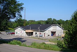
Wollaston is an incorporated township in Hastings County, Ontario, Canada. The township had a population of 670 in the Canada 2016 Census.

Partridge Creek is a creek in the Moira River and Lake Ontario drainage basins in Hastings and Lennox and Addington Counties, Ontario, Canada.

Merrill Lake is a lake in the Moira River and Lake Ontario drainage basins that straddles the border between the Cashel portion of Tudor and Cashel, Hastings County and Addington Highlands, Lennox and Addington County in Ontario, Canada.

<span class="mw-page-title-main">Bay of Quinte (federal electoral district)</span> Federal electoral district in Ontario, Canada

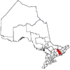
Bay of Quinte is a federal electoral district in central Ontario, Canada, centred on the Bay of Quinte.

Elections were held in Hastings County, Ontario, Canada, on October 27, 2014, in conjunction with municipal elections across the province.

<span class="mw-page-title-main">Chisholm's Mills</span> Canadian lumber mill, built 1851

Chisholm's Mills is a water-powered lumber mill on the Moira River in Tyendinaga township, Ontario, Canada. It was constructed in 1851 and bought by William Fraser Chisholm in 1857, leading to the creation of the Chisholm Lumbar company.

Elections were held in Hastings County, Ontario on October 24, 2022, in conjunction with municipal elections across the province.

References

  1. 1 2 3 "Census Profile, 2016 Census: Tudor and Cashel, Township". Statistics Canada . Retrieved June 15, 2019.
  2. Map of Tudor Township circa 1865 (Creation). Hastings County Historical Society (1957-). Repository: Community Archives of Belleville and Hastings County. Accessed 1 June 2020.
  3. Map of Cashel Township circa 1869 (Creation). By MacLeod and Carre, P.L.S. (1861-1867). Repository: Community Archives of Belleville and Hastings County. Accessed 31 May 2020.
  4. Archives of Ontario; Toronto, Ontario, Canada; Collection: MS935; Reel: 83. Accessed via ancestry.com paid subscription 31 May 2020.
  5. Limerick Township : Petition to separate from Tudor Township 9 December 1868 (Creation). Hastings County Historical Society (1957-). Repository: Community Archives of Belleville and Hastings County. File contains a manuscript report of the Hastings County Council Committee of Whole, 1868, finding against a petition for the separation of Wollaston and Limerick Townships from Tudor Township and the creation of separate township councils. Accessed 1 June 2020.
  6. Geology of Limerick and Tudor Townships, Hastings County. By S. B. Lumbers. Geological Report 67. Ontario Department of Mines, publ. Toronto, 1969.
  7. Plan of Millbridge in the Township of Tudor 28 March 1867 (Creation). By Charles Fraser Aylsworth Sr., P.L.S. (1834-1911). Repository: Community Archives of Belleville and Hastings County. Accessed 1 June 2020.
  8. "Population and dwelling counts: Canada, provinces and territories, census divisions and census subdivisions (municipalities), Ontario". Statistics Canada. February 9, 2022. Retrieved April 2, 2022.
  9. "2016 Community Profiles". 2016 Canadian Census . Statistics Canada. August 12, 2021. Retrieved 2012-03-02.
  10. "2011 Community Profiles". 2011 Canadian Census . Statistics Canada. March 21, 2019. Retrieved 2012-03-02.
  11. 1 2 "2006 Community Profiles". 2006 Canadian Census . Statistics Canada. August 20, 2019.
  12. "2001 Community Profiles". 2001 Canadian Census . Statistics Canada. July 18, 2021.
  13. 1996, 2001, 2006 census
  14. "Tudor and Cashel census profile". 2011 Census of Population . Statistics Canada. Retrieved 2012-03-02.

Commons-logo.svg Media related to Tudor and Cashel at Wikimedia Commons