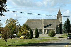
Tyendinaga | |
---|---|
Township of Tyendinaga | |
Coordinates: 44°18′N77°12′W / 44.300°N 77.200°W | |
Country | Canada |
Province | Ontario |
County | Hastings |
Incorporated | 1820 |
Government | |
• Type | Township |
• Mayor | Claire Kennelly |
• Federal riding | Hastings—Lennox and Addington |
• Prov. riding | Hastings—Lennox and Addington |
Area | |
• Land | 312.92 km2 (120.82 sq mi) |
Population (2016) [1] | |
• Total | 4,297 |
• Density | 13.7/km2 (35/sq mi) |
Time zone | UTC-5 (EST) |
• Summer (DST) | UTC-4 (EDT) |
Postal Code | K0K |
Area code(s) | 613, 343 |
Website | www.tyendinagatownship .com |
Tyendinaga is a township in the Canadian province of Ontario, located in Hastings County. The community takes its name from a variant spelling of Mohawk leader Joseph Brant's traditional Mohawk name, Thayendanegea.
The township comprises the communities of Albert, Blessington, Chisholms Mills, Ebenezer, Halston, Kingsford, Lonsdale, Lonsdale Station, Melrose, Marysville, Milltown, Myrehall, Naphan, Read and Shannonville.
A radio transmitter for the Canadian Broadcasting Corporation is located in Read. [2] Saint Charles Borromeo Cemetery is also located in Read.
In the 2021 Census of Population conducted by Statistics Canada, Tyendinaga had a population of 4,538 living in 1,650 of its 1,730 total private dwellings, a change of 7.4% from its 2016 population of 4,226. With a land area of 312.42 km2 (120.63 sq mi), it had a population density of 14.5/km2 (37.6/sq mi) in 2021. [3]
2016 | 2011 | |
---|---|---|
Population | 4,297 (+3.5% from 2011) | 4,150 (+2.0% from 2006) |
Land area | 312.92 km2 (120.82 sq mi) | 313.00 km2 (120.85 sq mi) |
Population density | 13.7/km2 (35/sq mi) | 13.3/km2 (34/sq mi) |
Median age | 42.5 (M: 42.5, F: 42.6) | |
Private dwellings | 1,631 (total) | 1,547 (total) |
Median household income | $81,408 |
Year | Pop. | ±% |
---|---|---|
1991 | 3,118 | — |
1996 | 3,549 | +13.8% |
2001 | 3,769 | +6.2% |
2006 | 4,070 | +8.0% |
2011 | 4,150 | +2.0% |
2016 | 4,295 | +3.5% |
[8] [9] [1] |
Mother tongue (2016 census): [1]
Shipman’s Flour and Sawmill was constructed in 1851 and bought by William Fraser Chisholm in 1857, and known as Chisholm's Mills since. [10]
Hastings County is located in the province of Ontario, Canada. Geographically, it is located on the border of Eastern Ontario and Central Ontario. Hastings County is the second-largest county in Ontario, after Renfrew County, and its county seat is Belleville, which is independent of Hastings County. Hastings County has trademarked the moniker "Cheese Capital of Canada".
North Grenville is a township in eastern Ontario, Canada, in the United Counties of Leeds and Grenville on the Rideau River. It is located just south of Ottawa in Canada's National Capital Region.
Carling is a township in Ontario, Canada, located in the District of Parry Sound on Georgian Bay. Killbear Provincial Park is located in the municipality.
Lanark Highlands is a township in eastern Ontario, Canada in Lanark County. The township administrative offices are located in the village of Lanark.
South Frontenac is a township in Frontenac County in eastern Ontario, Canada. It was amalgamated in 1998 from the former townships of Bedford, Loughborough, Portland, and Storrington.
White River is a township located in Northern Ontario, Canada, along Highway 17 of the Trans-Canada Highway. It was originally a rail town on the Canadian Pacific Railway in 1885.
Hamilton Township is a rural township located in Northumberland County in central Ontario. It surrounds the Town of Cobourg.
Red Rock is a township in Northwestern Ontario, Canada, located in the Thunder Bay District. The community of Red Rock sits on the shore of Lake Superior, about 16 km west of the Nipigon River where it drains into Nipigon Bay on the north shore of Lake Superior. The population as of 2011 is 942.
Évanturel is a township in Timiskaming District, Ontario, Canada. It almost completely surrounds the town of Englehart. The main settlement in Évanturel is the community of Heaslip.
Deseronto is a town in the Canadian province of Ontario, in Hastings County, located at the mouth of the Napanee River on the shore of the Bay of Quinte, on the northern side of Lake Ontario.
Carlow Mayo is a township in northern Hastings County in Eastern Ontario, Canada. It was formed in 2001 by the amalgamation of the townships of Carlow and Mayo.
Burpee and Mills is a township in the Canadian province of Ontario. It was formed on January 1, 1998, through the annexation of the unorganized geographic township of Mills by Burpee Township.
Rideau Lakes is a township located within Leeds and Grenville United Counties in Eastern Ontario, Canada. The township was incorporated on 1 January 1998 by amalgamating the former townships of North Crosby, South Crosby, Bastard, South Burgess and South Elmsley with the village of Newboro.
Merrickville–Wolford is a village-status municipality in Eastern Ontario, Canada, located in the United Counties of Leeds and Grenville. It spans both shores of the Rideau River.
The North Shore is a township in the Canadian province of Ontario, located in the Algoma District. The township had a population of 497 in the Canada 2016 Census. It is along the north shore of the North Channel of Lake Huron, with its main communities all along Highway 17.
Opasatika is a township in the Canadian province of Ontario, located in the Cochrane District on the Opasatika River, a tributary of the Missinaibi River. Its name is of First Nation origin, meaning "river lined with poplars".
Jocelyn is a township in the Canadian province of Ontario, located on St. Joseph Island in the Algoma District. The current reeve of the township is Mark Henderson. Jocelyn is home to Fort St. Joseph National Historic Site.
Fauquier-Strickland is a township municipality in Cochrane District in Northeastern Ontario, Canada. The three main communities in the township are Fauquier, Strickland, and Gregoires Mill. All are located along Ontario Highway 11 between the community of Departure Lake to the east and the municipality of Moonbeam to the west.
Dubreuilville is a township in the Canadian province of Ontario, located in the Algoma District. Established as a company town in 1961 by the Dubreuil Brothers lumber company, Dubreuilville was incorporated as a municipality in 1977.
Harley is a township in the Canadian province of Ontario. Located within the Timiskaming District, Harley is located directly north of the city of Temiskaming Shores.