| Twin Peaks | |
|---|---|
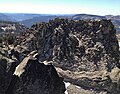
 South aspect | |
| Highest point | |
| Elevation | 8,878 ft (2,706 m) [1] [2] |
| Prominence | 1,318 ft (402 m) [3] |
| Parent peak | Squaw Peak (8,885 ft) [4] |
| Isolation | 5.15 mi (8.29 km) [4] |
| Listing | Tahoe OGUL Peak [5] |
| Coordinates | 39°06′44″N120°13′54″W / 39.1123183°N 120.2318051°W [6] |
| Geography | |
 Twin Peaks Location in California  Twin Peaks Twin Peaks (the United States) | |
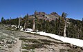
| Location | Granite Chief Wilderness |
| Country | United States of America |
| State | California |
| County | Placer |
| Parent range | Sierra Nevada [3] |
| Topo map | USGS Homewood |
| Climbing | |
| Easiest route | class 2 [7] |
Twin Peaks is an 8,878-foot-elevation (2,706-meter) double summit mountain in Placer County, California, United States.