Rusk County is a county in the U.S. state of Wisconsin. As of the 2010 census, the population was 14,755. Its county seat is Ladysmith.
Iron County is a county located in the U.S. state of Wisconsin. As of the 2010 census, the population was 5,916, making it the third-least populous county in Wisconsin. Its county seat is Hurley. It was named for the valuable iron ore found within its borders.

Anderson is a town in Iron County, Wisconsin, United States. The population was 61 at the 2000 census. The unincorporated communities of Rouse, Tyler Forks, and Upson are located in the town.

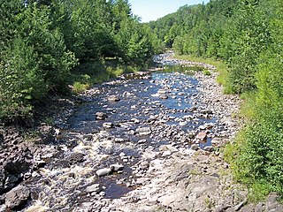
The Montreal River is a river flowing to Lake Superior in northern Wisconsin and the Upper Peninsula of Michigan in the United States. It is 47.8 miles (76.9 km) long and drains approximately 270 square miles (700 km2) in a forested region. For most of its length, the river's course defines a portion of the Wisconsin–Michigan border. The Ojibwe name for the river is Gaa-waasijiwaang, meaning "where there is whitewater".

Connorsville is an unincorporated community in Dunn County, Wisconsin, United States, located along the South Fork of the Hay River in the town of New Haven.
The Bad River is a river flowing to Lake Superior in northern Wisconsin in the United States. It flows for 119.6 kilometres (74.3 mi) in Ashland County, draining an area of 1,061 square miles (2,750 km2) in portions of Ashland, Bayfield and Iron counties. The Bad River sloughs were designated a Ramsar Wetland of International Importance on February 2, 2012.

The Bad Axe River is a 4.2-mile-long (6.8 km) tributary of the Mississippi River in southwestern Wisconsin in the United States. "Bad axe" is a translation from the French, "la mauvaise hache", but the origin of the name is unknown. The river's mouth at the Mississippi was the site of the Battle of Bad Axe, an 1832 U.S. Army massacre of Sac and Fox Indians at the end of the Black Hawk War.
Kittel Halvorson was a U.S. Representative from Minnesota.

The Flambeau River is a tributary of the Chippewa River in northern Wisconsin, United States. The Chippewa is in turn a tributary of the upper Mississippi River. The Flambeau drains an area of 1,860 square miles (4,800 km2) and descends from an elevation of approximately 1,570 feet (480 m) to 1,060 feet (320 m) above sea level. The Flambeau is an important recreational destination in the region. It is notable among canoeists in the Midwest for outstanding canoe camping, including excellent scenery, fishing and whitewater. The river and its forks have a variety of possible trip lengths from short day outings, to overnight camping, to voyages of a week or more.

The 2010 congressional elections in Montana was held on November 2, 2010, and determined who would represent the state of Montana in the United States House of Representatives. Montana has one seat in the House, apportioned according to the 2000 United States Census. Representatives are elected for two-year terms; the elected will serve in the 112th Congress from January 3, 2011 until January 3, 2013.
South Fork is an unincorporated community is located in the Town of South Fork, in Rusk County, Wisconsin, United States. Originally known as Czestochowa, after Częstochowa, Poland and having its name changed to the current name in 1917, South Fork is located along County Highway M, north of Village of Hawkins. The South Fork Townhall and the former South Fork School are located within this community.
Newton is an unincorporated community located in the town of Harmony, Vernon County, Wisconsin, United States. Newton is located on the North Fork Bad Axe River 9 miles (14 km) east-northeast of Viroqua.

Hayton is an unincorporated community in the town of Charlestown, Calumet County, Wisconsin, United States. It is located a few miles (kilometers) east of Chilton at the intersection of U.S. Route 151 and County T.
Caldwell is an unincorporated community located in the town of Waterford, Racine County, Wisconsin, United States. The community was named for settlers Joseph and Tyler Caldwell, two brothers from Vermont who arrived in the area around 1836.
The following television stations operate on virtual channel 48 in the United States:
The following television stations operate on virtual channel 27 in the United States:

Conaway is an unincorporated community in Tyler County, West Virginia, United States along Elk Fork. Its post office is closed.
This page is based on this
Wikipedia article Text is available under the
CC BY-SA 4.0 license; additional terms may apply.
Images, videos and audio are available under their respective licenses.


