
The 2005 Pacific typhoon season was the least active typhoon season since 2000, producing 23 named storms, of which 13 became typhoons. It was an event in the annual cycle of tropical cyclone formation, in which tropical cyclones form in the western Pacific Ocean. The season ran throughout 2005, though most tropical cyclones typically develop between May and October. The season's first named storm, Kulap, developed on January 13, while the season's last named storm, Bolaven, dissipated on November 20. The season's first typhoon, Haitang, reached typhoon status on July 13, and became the first super typhoon of the year three days later.

The 2001 Pacific typhoon season was an average season with twenty-six named storms, sixteen typhoons and three super typhoons, with a near normal Accumulated Cyclone Energy (ACE) of 307.3 units. It ran year-round in 2001, with most tropical cyclones in the northwestern Pacific Ocean tending between May and November.

Typhoon Shanshan, known in the Philippines as Super Typhoon Luis, was a strong typhoon that affected parts of East Asia in late September 2006. The 13th named storm of the 2006 Pacific typhoon season, Typhoon Shanshan was also the seventh typhoon of the year operationally recognised by the Japan Meteorological Agency. In post-operational analysis Shanshan became the eighth typhoon of the year when Typhoon Maria was added to the list. The Joint Typhoon Warning Center considered Shanshan the 13th tropical storm and eighth typhoon of the season, a Category 4-equivalent typhoon in terms of 1-minute average wind speed. The name Shanshan was submitted to the naming list by Hong Kong and is a girls' given name.

Typhoon Nabi, known in the Philippines as Super Typhoon Jolina, was a powerful typhoon that struck southwestern Japan in September 2005. The 14th named storm of the 2005 Pacific typhoon season, Nabi formed on August 29 to the east of the Northern Mariana Islands. It moved westward and passed about 55 km (34 mi) north of Saipan on August 31 as an intensifying typhoon. On the next day, the Joint Typhoon Warning Center upgraded the storm to super typhoon status, with winds equivalent to that of a Category 5 hurricane on the Saffir–Simpson Hurricane Scale. The Japan Meteorological Agency estimated peak ten-minute winds of 175 km/h (109 mph) on September 2. Nabi weakened while curving to the north, striking the Japanese island of Kyushu on September 6. After brushing South Korea, the storm turned to the northeast, passing over Hokkaido before becoming extratropical on September 8, before dissipating on September 12.

The 2017 Pacific typhoon season was a below-average season in terms of accumulated cyclone energy and the number of typhoons and super typhoons, and the first since the 1977 season to not produce a Category 5-equivalent typhoon on the Saffir–Simpson scale. The season produced a total of 27 named storms, 11 typhoons, and only two super typhoons, making it an average season in terms of storm numbers. It was an event in the annual cycle of tropical cyclone formation, in which tropical cyclones form in the western Pacific Ocean. The season runs throughout 2017, though most tropical cyclones typically develop between May and October. The season's first named storm, Muifa, developed on April 25, while the season's last named storm, Tembin, dissipated on December 26. This season also featured the latest occurrence of the first typhoon of the year since 1998, with Noru reaching this intensity on July 23.

The 2018 Pacific typhoon season was at the time, the costliest Pacific typhoon season on record, until the record was beaten by the following year. The season was well above-average, producing twenty-nine storms, thirteen typhoons, seven super typhoons and six Category 5 tropical cyclones. The season ran throughout 2018, though most tropical cyclones typically develop between May and October. The season's first named storm, Bolaven, developed on January 3, while the season's last named storm, Man-yi, dissipated on November 28. The season's first typhoon, Jelawat, reached typhoon status on March 29, and became the first super typhoon of the year on the next day.

Typhoon Francisco, known in the Philippines as Typhoon Urduja, was a powerful typhoon that strengthened to the equivalent of a Category 5 on the Saffir-Simpson scale, according to the Joint Typhoon Warning Center. The 25th named storm and the 10th typhoon of the 2013 Pacific typhoon season, Francisco formed on October 16 east of Guam from a pre-existing area of convection. With favorable conditions, it quickly intensified into a tropical storm before passing south of Guam. After stalling to the southwest of the island, Francisco turned to the northwest into an environment of warm waters and low wind shear, becoming a typhoon. The JTWC upgraded it to super typhoon status on October 18, while the Japan Meteorological Agency (JMA) estimated peak 10-minute sustained winds of 195 km/h (121 mph). Gradual weakening ensued, and after the typhoon turned to the northeast, Francisco deteriorated into a tropical storm on October 24. Passing southeast of Okinawa and mainland Japan, the storm accelerated and became extratropical on October 26, dissipating later that day.

Typhoon Lingling, known in the Philippines as Typhoon Nanang, was a deadly typhoon that struck the Philippines and Vietnam in 2001 and caused 379 deaths. The name "Lingling" was given by Hong Kong. The 39th tropical depression, 22nd named storm, and 13th typhoon of the 2001 Pacific typhoon season, Lingling developed into a tropical depression on November 6 and given the local name Nanang by the PAGASA. The next day, it was upgraded into a tropical storm and given the name Lingling by the Japan Meteorological Agency (JMA). Lingling's intensity briefly stagnated as it moved over Visayas before resuming intensification and intensifying into a severe tropical storm on November 8. One day later, both the JMA and the Joint Typhoon Warning Center (JTWC) upgraded Lingling to a typhoon as it exited the Philippine archipelago and moved into the South China Sea. After intensifying into a typhoon, Lingling began to quickly intensify, peaking with 10-min sustained winds of 155 km/h (96 mph) and 1-min sustained winds of 215 km/h (134 mph), with a minimum central pressure of 940 mbar (28 inHg). Lingling began to weaken as it approached the Vietnamese coast, before making landfall on November 11 at 18:00 UTC. Lingling rapidly weakened afterward, dissipating on November 12.

Typhoon Wendy was a weak typhoon that damaged Japan in August of the 1960 Pacific typhoon season. On August 10, a tropical depression formed near Typhoon Virginia and strengthened to a tropical storm later that day, receiving the name Wendy from the Joint Typhoon Warning Center (JTWC). The storm continued to intensify as it traveled toward the Japanese archipelago, becoming a typhoon a day after formation. The typhoon peaked with winds of 140 kilometres per hour (85 mph) while located south of Japan. Wendy made landfalls in Shikoku and Honshu on August 12, and became extratropical on August 13. The Japan Meteorological Agency (JMA) stopped tracking the cyclone on August 15.

Typhoon Mindulle was a strong tropical cyclone which affected Japan in August 2016. The ninth named storm and second typhoon of the 2016 Pacific typhoon season, Mindulle was first noted as a low-pressure area northwest of Guam on August 17. Two days later, it was upgraded into a tropical storm, being named Mindulle. Gradually intensifying, Mindulle peaked as a Category 1-equivalent hurricane on the Saffir-Simpson scale on August 22 before making landfall in Chiba Prefecture later that day. Mindulle rapidly weakened, dissipating the next day.

Typhoon Charlotte was a damaging typhoon that struck Okinawa during the 1959 Pacific typhoon season. An area of low pressure developed in early October, and it became a tropical depression on October 9. The depression strengthened to a tropical storm one day later, and it received the name Charlotte from the Joint Typhoon Warning Center (JTWC). The system strengthened quickly and became a typhoon eighteen hours later. Charlotte continued to rapidly strengthen to its peak of 260 km/h (160 mph) on October 13. The typhoon began to weaken afterwards, and it traveled south of Okinawa on October 16. The typhoon weakened to a tropical storm on October 19 as it began its extratropical transition. The storm became extratropical later that day, and the Japan Meteorological Agency (JMA) ceased tracking the system on October 20.

The 2021 Pacific typhoon season was the second consecutive to have below average tropical cyclone activity, with twenty-two named storms, and was the least active since 2011. Nine became typhoons, and five of those intensified into super typhoons. This low activity was caused by a strong La Niña that had persisted from the previous year. The season's first named storm, Dujuan, developed on February 16, while the last named storm, Rai, dissipated on December 21. The season's first typhoon, Surigae, reached typhoon status on April 16. It became the first super typhoon of the year on the next day, also becoming the strongest tropical cyclone in 2021. Surigae was also the most powerful tropical cyclone on record in the Northern Hemisphere for the month of April. Typhoons In-fa and Rai are responsible for more than half of the total damage this season, adding up to a combined total of $2.02 billion.

The 2022 Pacific typhoon season was the third consecutive season to have below average tropical cyclone activity, with twenty-five named storms forming. Of the tropical storms, ten became typhoons, and three would intensify into super typhoons. The season saw near-average activity by named storm count, although many of the storms were weak and short-lived, particularly towards the end of the season. This low activity was caused by an unusually strong La Niña that had persisted from 2020. The season's first named storm, Malakas, developed on April 6, while the last named storm, Pakhar, dissipated on December 12. The season's first typhoon, Malakas, reached typhoon status on April 12. The season ran throughout 2022, though most tropical cyclones typically develop between May and October. Tropical storms Megi and Nalgae were responsible for more than half of the casualties, while typhoons Hinnamnor and Nanmadol both caused $1 billion in damages.

Typhoon Emma was a strong typhoon that struck Okinawa during the 1959 Pacific typhoon season. An area of severe weather formed near Kwajalein Atoll on October 30, and the Japan Meteorological Agency (JMA) began tracking it as a tropical depression on November 1. The Joint Typhoon Warning Center followed suit on November 5 after finding a closed circulation, and the depression received the name Emma. The depression strengthened into a tropical storm west of Guam on November 6 and gradually gained strength. Emma became a typhoon on November 11 near Luzon, and it reached its peak sustained winds of 205 km/h; 125 mph (110 kn) later that day. The typhoon turned northeastwards and grazed Okinawa the next day. Emma steadily weakened and became extratropical on November 13, and the JMA ceased tracking the storm on November 15.

Typhoon Prapiroon, known in the Philippines as Severe Tropical Storm Florita, was a Category 1 typhoon that worsened the floods in Japan and also caused impacts in neighboring South Korea. The storm formed from an area of low pressure near the Philippines and strengthened to a typhoon before entering the Sea of Japan. The seventh named storm and the first typhoon of the annual annual typhoon season. Prapiroon originated from a low-pressure area far off the coast of Northern Luzon on June 28. Tracking westwards, it rapidly upgraded into a tropical storm, receiving the name Prapiroon due to favorable conditions in the Philippine Sea on the next day.

Severe Tropical Storm Maliksi, known in the Philippines as Severe Tropical Storm Domeng, was a tropical cyclone in June 2018 that brought rainfall to the Philippines and Japan. It caused 2 deaths and prompted the PAGASA to declare the beginning of the rainy season in the Philippines. The fifth named storm and 4th tropical cyclone in the Philippine Area of Responsibility (PAR), it was first noted as an area of convection in the South of Palau on May 31.

Severe Tropical Storm Kompasu, known in the Philippines as Severe Tropical Storm Maring was a very large and deadly tropical cyclone that affected the Philippines, Taiwan, and southeast China. Part of the 2021 Pacific typhoon season, Kompasu originated from an area of low pressure east of the Philippines on 6 October 2021. The Japan Meteorological Agency (JMA) classified it as a tropical depression that day. A day later, the Philippine Atmospheric, Geophysical and Astronomical Services Administration (PAGASA) classified it as a tropical depression, naming it Maring. The cyclone was initially heavily disorganised, competing with another vortex, Tropical Depression Nando. Eventually, Maring became dominant, and the JMA reclassified it as a tropical storm, naming it Kompasu. Kompasu made landfall in Cagayan, Philippines, on 11 October 2021, and two days later, the storm made landfall in Hainan, China. The cyclone dissipated on 14 October 2021 while located over Vietnam.
Typhoon June was a large, strong and devastating typhoon that severely impacted the west and central areas of mainland Japan, causing scores of deaths and heavy devastation. A large storm, it was the tenth storm to be tracked by the Fleet Weather Center (FWC) during the 1954 Pacific typhoon season. The storm was already a tropical storm when it was first noticed by both the FWC and JMA by September 4. Only six hours later, the storm intensified into a typhoon and underwent rapid intensification into a modern-day Category 4 super typhoon just east of northern Luzon in the Philippines with maximum sustained winds of 130 knots calculated in 1-minute sustained winds along with JMA's estimates of its minimum pressure of 910 millibars (27 inHg) on September 7. However, it started to weaken below super typhoon status, and its intensity began to fluctuate while moving northwestwards and north-northwestwards. As it turned northwards by September 12, June regained its intensity as a Category 4 system before making landfall over Yamaguchi Prefecture's Shimonoseki City. There, it weakened and crossed into the Sea of Japan as a tropical storm. Data from the now-Joint Typhoon Warning Center indicated that as the storm made landfall somewhere Primorsky Krai, it retained its tropical storm status. Upon moving inland, it degenerated into an extratropical low before being last monitored by FWC during September 15. However, the JMA did the same on the next day at 06:00 UTC.

Typhoon Lorna was a strong Category 3 typhoon that severely impacted some areas of Honshu Island, especially Yokohama and Tokyo while also causing damages across the Northern Mariana Islands. The second typhoon to hit Japan after Typhoon June in September, it is the eleventh system to be monitored by the FWC during the 1954 Pacific typhoon season. The storm was first tracked by the JMA on September 10, before the FWC followed suit on the next day. After intensifying into a tropical storm by the latter time, it struggled to strengthen further until it intensified into a modern-day Category 1 typhoon on the Saffir–Simpson scale. It then passed just north of the Marianas around September 13, before turning northwestwards on the next day. It then continued to strengthen into a Category 2 typhoon at the morning of September 15 before becoming a Category 3 system on the afternoon of that day. It remained in this strength before it degraded below that status around the next day. On September 17, Lorna was seized by a frontal system, forcing it to move north-northeastwards and make landfall over the Boso Peninsula on the next day. Its eye reportedly passed through Yokohama at that day. It then rapidly degenerated into an extratropical system as it pulled away from Japan, being last monitored by the JMA on September 22.
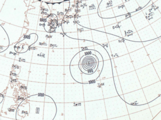
Typhoon Pabuk was a high-end Category 2 typhoon that struck Japan in August 2001. As the tenth named storm and the fifth typhoon of the 2001 Pacific typhoon season, it originated from a tropical depression to the north-northwest of Saipan. It began to develop rapidly, so the Joint Typhoon Warning Center issued a Tropical Cyclone Formation Alert. The same agency began to issue advisories on the system; thereafter, the depression was designated 14W. Every agency upgraded the depression to a tropical storm, gaining the name Pabuk from the Japan Meteorological Agency. Pabuk gradually intensified as it moved northwestward, getting upgraded to a typhoon by the JTWC on August 15, with the JMA following suit not too long after. By August 17, Pabuk briefly reached its initial peak strength as a low-end Category 2 typhoon before slowly weakening. The following day, Pabuk began to re-intensify. Pabuk also began to form an eye. By August 19, Pabuk reached its second peak intensity with 1-minute sustained winds of 165 km/h (105 mph). Pabuk grew in size, and its eye became irregular, hinting on a weakening trend while moving north northeastward. Pabuk weakened to tropical storm intensity when it hit the southern coast of Japan, south of Osaka, on August 21. On August 22, both the JMA and the JTWC issued their final advisories after Pabuk became extratropical. The name Pabuk was submitted by Laos and refers to the Mekong giant catfish. Pabuk brought heavy rain to Japan and damaged fields. Pabuk caused 8 fatalities and caused $52 million in damages.


