
The 2012 Pacific typhoon season was a slightly above average season that produced 25 named storms, fourteen typhoons, and four intense typhoons. It was a destructive and the second consecutive year to be the deadliest season, primarily due to Typhoon Bopha which killed 1,901 people in the Philippines. It was an event in the annual cycle of tropical cyclone formation, in which tropical cyclones form in the western Pacific Ocean. The season ran throughout 2012, though most tropical cyclones typically develop between May and October. The season's first named storm, Pakhar, developed on March 28, while the season's last named storm, Wukong, dissipated on December 29. The season's first typhoon, Guchol, reached typhoon status on June 15, and became the first super typhoon of the year on June 17.

The 2013 Pacific typhoon season was the most active Pacific typhoon season since 2004, and the deadliest since 1975. It featured Typhoon Haiyan, one of the most powerful storms and one of the strongest landfalling tropical cyclones in history. It was an above-average season with 31 named storms, 13 typhoons, and five super typhoons. The season's first named storm, Sonamu, developed on January 4 while the season's last named storm, Podul, dissipated on November 15. Despite the activity, most of the first seventeen named storms before mid-September were relatively weak, as only two of them reached typhoon intensity. Total damage amounted to at least $26.41 billion (USD), making it at the time the costliest Pacific typhoon season on record; it is currently the fourth costliest, behind the 2018, 2019 and 2023 seasons.

The 2015 Pacific typhoon season was a slightly above average season that produced twenty-seven tropical storms, eighteen typhoons, and nine super typhoons. The season ran throughout 2015, though most tropical cyclones typically develop between May and November. The season's first named storm, Mekkhala, developed on January 15, while the season's last named storm, Melor, dissipated on December 17. The season saw at least one named tropical system forming in each of every month, the first time since 1965. Similar to the previous season, this season saw a high number of super typhoons. Accumulated cyclone energy (ACE) during 2015 was extremely high, the third highest since 1970, and the 2015 ACE has been attributed in part to anthropogenic warming, and also the 2014-16 El Niño event, that led to similarly high ACE values in the East Pacific.

The 2016 Pacific typhoon season is considered to have been the fourth-latest start for a Pacific typhoon season since reliable records began. It was an average season, with a total of 26 named storms, 13 typhoons, and six super typhoons. The season ran throughout 2016, though typically most tropical cyclones develop between May and October. The season's first named storm, Nepartak, developed on July 3, while the season's last named storm, Nock-ten, dissipated on December 28.

The 2018 Pacific typhoon season was at the time, the costliest Pacific typhoon season on record, until the record was beaten by the following year. The season was well above-average, producing twenty-nine storms, thirteen typhoons, seven super typhoons and six Category 5 tropical cyclones. The season ran throughout 2018, though most tropical cyclones typically develop between May and October. The season's first named storm, Bolaven, developed on January 3, while the season's last named storm, Man-yi, dissipated on November 28. The season's first typhoon, Jelawat, reached typhoon status on March 29, and became the first super typhoon of the year on the next day.

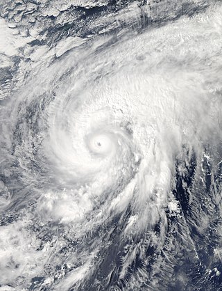
Typhoon Guchol, known in the Philippines as Super Typhoon Butchoy, was a powerful tropical cyclone which became the first typhoon to make landfall in Japan on June since 2004. The storm formed as tropical disturbance south-southeast of Pohnpei on June 7, and was upgraded to a tropical depression on June 10. The system later intensified in favorable conditions, and reached typhoon intensity on June 15. It reached peak intensity late on June 17, before making landfall over Japan as a typhoon on June 19. The system became extratropical shortly after traversing Japan and was last noted by the Japan Meteorological Agency on June 22.

Typhoon Francisco, known in the Philippines as Typhoon Urduja, was a powerful typhoon that strengthened to the equivalent of a Category 5 on the Saffir-Simpson scale, according to the Joint Typhoon Warning Center. The 25th named storm and the 10th typhoon of the 2013 Pacific typhoon season, Francisco formed on October 16 east of Guam from a pre-existing area of convection. With favorable conditions, it quickly intensified into a tropical storm before passing south of Guam. After stalling to the southwest of the island, Francisco turned to the northwest into an environment of warm waters and low wind shear, becoming a typhoon. The JTWC upgraded it to super typhoon status on October 18, while the Japan Meteorological Agency (JMA) estimated peak 10-minute sustained winds of 195 km/h (121 mph). Gradual weakening ensued, and after the typhoon turned to the northeast, Francisco deteriorated into a tropical storm on October 24. Passing southeast of Okinawa and mainland Japan, the storm accelerated and became extratropical on October 26, dissipating later that day.

Typhoon Neoguri, known in the Philippines as Typhoon Florita, was a large and powerful tropical cyclone which struck Japan in 2014. The eighth named storm and the second typhoon of the annual typhoon season, Neoguri developed into a tropical storm on July 3 and then a typhoon on July 4. It rapidly deepened on July 5, reaching peak intensity late on July 6. Neoguri began to decay on July 7 and passed through Okinawa on July 8 and then making landfall over Kyushu as a severe tropical storm late on July 9. After Neoguri passed through the southern coast of Honshū on July 10, it became extratropical on July 11.

Typhoon Vongfong, known in the Philippines as Super Typhoon Ompong, was the most intense tropical cyclone worldwide in 2014, and struck Japan as a large tropical system. It also indirectly affected the Philippines and Taiwan. Vongfong was the nineteenth named storm and the ninth typhoon of the 2014 Pacific typhoon season. Estimates assess damage from Vongfong to have been over US$160 million, mainly for striking mainland Japan. At least 9 people were killed along the path of the typhoon in those countries.
Typhoon Nuri, known in the Philippines as Super Typhoon Paeng, was the third most intense tropical cyclone worldwide in 2014. Nuri developed into a tropical storm and received the name Paeng from the PAGASA on October 31, before it intensified into a typhoon on the next day. Under excellent conditions, especially the synoptic scale outflow, Nuri underwent rapid deepening and reached its peak intensity on November 2, forming a round eye in a symmetric Central dense overcast (CDO). Having maintained the impressive structure for over one day, the typhoon began to weaken on November 4, with a cloud-filled eye.

Typhoon Hagupit known in the Philippines as Super Typhoon Ruby, was the second most intense tropical cyclone in 2014. Hagupit particularly impacted the Philippines in early December while gradually weakening, killing 18 people and causing $114 million of damage in the country. Prior to making landfall, Hagupit was considered the worst threat to the Philippines in 2014, but it was significantly smaller than 2013's Typhoon Haiyan.

Severe Tropical Storm Mekkhala, known in the Philippines as Severe Tropical Storm Amang, was an early-season tropical cyclone that made landfall over the Philippines in January 2015. Mekkhala killed three people in the Bicol Region and caused light crop damage. Notably, the storm disturbed Pope Francis’ visit to the country after the victims of Typhoon Haiyan on November 8, 2013. Although the storm also caused an airplane crash in Tacloban, nobody was hurt in the incident.
Typhoon Melor, known in the Philippines as Typhoon Nona, was a powerful tropical cyclone that struck the Philippines in December 2015. The twenty-seventh named storm and the eighteenth typhoon of the annual typhoon season, Melor killed 51 people and caused ₱7.04 billion in damage.

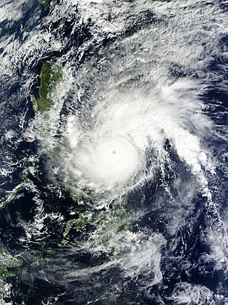
Typhoon Haima, known in the Philippines as Super Typhoon Lawin, was the third most intense tropical cyclone worldwide in 2016. It was the twenty-second named storm and the eleventh typhoon of the annual typhoon season. Impacting the Philippines less than 3 days after Typhoon Sarika, Haima formed out of a tropical disturbance southwest of Chuuk on October 14, it developed into a tropical storm the next day. Steady strengthening occurred over the next day or two as it tracked westward towards the Philippines. After forming an eye shortly after it was upgraded to a typhoon, Haima began to rapidly strengthen and eventually became a super typhoon on October 18. It later attained its peak intensity as a Category 5-equivalent tropical cyclone before weakening slightly. Haima later made landfall in Peñablanca, Cagayan late on October 19 as a Category 4-equivalent storm. Rapid weakening occurred as it interacted with the landmasses until it entered the Southern China Sea as a weak typhoon. It formed a large ragged eye once again and remained steady in intensity until making landfall in China on October 21. It weakened below typhoon intensity and became extratropical on October 22. The cyclone drifted northeastwards and later eastwards before emerging over water again, but eventually dissipated by October 26.

Typhoon Noru was the second-longest-lasting tropical cyclone of the Northwest Pacific Ocean on record—behind only 1986's Wayne and tied with 1972's Rita—and the second-most-intense tropical cyclone of the basin in 2017, tied with Talim. Forming as the fifth named storm of the annual typhoon season on July 20, Noru further intensified into the first typhoon of the year on July 23. However, Noru began to interact with nearby Tropical Storm Kulap on July 24, executing a counterclockwise loop southeast of Japan. Weakening to a severe tropical storm on July 28, Noru began to restrengthen as it turned sharply to the west on July 30. Amid favorable conditions, Noru rapidly intensified into the season's first super typhoon, and reached peak intensity with annular characteristics on July 31. In early August, Noru underwent a gradual weakening trend while curving northwestwards and then northwards. After stalling off the Satsunan Islands weakening to a severe tropical storm again on August 5, the system began to accelerate northeastwards towards the Kansai region of Japan, making landfall in Wakayama Prefecture on August 7. Noru became extratropical over the Sea of Japan on August 8, and dissipated one day later.

Typhoon Nesat, known in the Philippines as Typhoon Gorio, was a strong tropical cyclone that impacted Taiwan and Fujian, China. It was the ninth named storm and the second typhoon of the annual typhoon season. After consolidating slowly for several days, Tropical Storm Nesat developed east of the Philippines on July 25. While experiencing favorable environmental conditions such as very warm sea surface temperatures and low wind shear, Nesat strengthened into a typhoon and reached its peak intensity on July 28. On July 29, the typhoon made landfall near the Taiwanese city of Yilan, before weakening to a severe tropical storm and making landfall again near Fuqing on China's east coast late the same day. Moving into July 30, Nesat continued to weaken under the effects of land interaction.

Typhoon Lan, known in the Philippines as Super Typhoon Paolo, was the third-most intense tropical cyclone worldwide in 2017, behind only hurricanes Irma and Maria in the Atlantic. A very large storm, Lan was the twenty-first tropical storm and ninth typhoon of the annual typhoon season. It originated from a tropical disturbance that the United States Naval Research Laboratory had begun tracking near Chuuk on October 11. Slowly consolidating, it developed into a tropical storm on October 15, and intensified into a typhoon on October 17. It expanded in size and turned northward on October 18, although the typhoon struggled to intensify for two days. On October 20, Lan grew into a very large typhoon and rapidly intensified, due to favorable conditions, with a large well-defined eye, reaching peak intensity as a "super typhoon" with 1-minute sustained winds of 249 km/h (155 mph) – a high-end Category 4-equivalent storm – late on the same day. Afterward, encroaching dry air and shear caused the cyclone to begin weakening and turn extratropical, before it struck Japan on October 23 as a weaker typhoon. Later that day, it became fully extratropical before it was absorbed by a larger storm shortly afterward.

Typhoon Damrey, known in the Philippines as Severe Tropical Storm Ramil, was a strong tropical cyclone that affected the Philippines and Vietnam during early November 2017. Damrey first originated as a tropical depression over the Philippine archipelago of Visayas on October 31. Emerging into the South China Sea a few days later, the system strengthened into the second deadliest and twenty-third named storm of the 2017 Pacific typhoon season. Rapidly intensifying, Damrey became the season's tenth typhoon on November 3, reaching its peak intensity as a Category 2 on the same day. Damrey made landfall over Khánh Hoà, Vietnam on November 4 and began to rapidly weaken, fully dissipating on November 5.

The 2021 Pacific typhoon season was the second consecutive to have below average tropical cyclone activity, with twenty-two named storms, and was the least active since 2011. Nine became typhoons, and five of those intensified into super typhoons. This low activity was caused by a strong La Niña that had persisted from the previous year. The season's first named storm, Dujuan, developed on February 16, while the last named storm, Rai, dissipated on December 21. The season's first typhoon, Surigae, reached typhoon status on April 16. It became the first super typhoon of the year on the next day, also becoming the strongest tropical cyclone in 2021. Surigae was also the most powerful tropical cyclone on record in the Northern Hemisphere for the month of April. Typhoons In-fa and Rai are responsible for more than half of the total damage this season, adding up to a combined total of $2.02 billion.

The 2022 Pacific typhoon season was the third consecutive season to have below average tropical cyclone activity, with twenty-five named storms forming. Of the tropical storms, ten became typhoons, and three would intensify into super typhoons. The season saw near-average activity by named storm count, although many of the storms were weak and short-lived, particularly towards the end of the season. This low activity was caused by an unusually strong La Niña that had persisted from 2020. The season's first named storm, Malakas, developed on April 6, while the last named storm, Pakhar, dissipated on December 12. The season's first typhoon, Malakas, reached typhoon status on April 12. The season ran throughout 2022, though most tropical cyclones typically develop between May and October. Tropical storms Megi and Nalgae were responsible for more than half of the casualties, while typhoons Hinnamnor and Nanmadol both caused $1 billion in damages.


