Tōon, Ehime

Last updated • 3 min readFrom Wikipedia, The Free Encyclopedia
Tōon
東温市
Touon city-office.jpg
Tōon City Hall
Flag of Toon, Ehime.svg
Emblem of Toon, Ehime.svg
Toon, Ehime
Location of Tōon in Ehime Prefecture
Toon in Ehime Prefecture Ja.svg
Japan location map with side map of the Ryukyu Islands.svg
Red pog.svg
Tōon
Location in Japan
Coordinates: 33°47′N132°52′E / 33.783°N 132.867°E / 33.783; 132.867
CountryJapan
Region Shikoku
Prefecture Ehime
Government
  MayorAkira Katō (since November 2016)
Area
  Total
211.30 km2 (81.58 sq mi)
Population
 (September 1, 2022)
  Total
33,276
  Density160/km2 (410/sq mi)
Time zone UTC+09:00 (JST)
City hall address530-1 Minara, Tōon-shi, Ehime-ken 791-0292
Website Official website
Symbols
Flower Sakura ()
Tree Flowering dogwood (花水木, Hanamizuki)
Aerial view of Toon city center Toon city center area Aerial photograph.2010.jpg
Aerial view of Tōon city center

Tōon (東温市, Tōon-shi) is a city located in Ehime Prefecture, Japan. As of 1 September 2022, the city had an estimated population of 33,276 in 15571 households and a population density of 160 persons per km2. [1] The total area of the city is 211.30 square kilometres (81.58 sq mi). The city name may be romanized as 'Toon', [2] 'Tôon', [3] 'Tōon' [4] or 'Tohon'. [5]

Contents

Geography

Tōon is located in central Ehime Prefecture on the island of Shikoku. It is the only city in Ehime Prefecture that does not face the sea. Located at the top of the alluvial fan of Dogo Plain, Toon is bordered on the east by Matsuyama, and with Saijō through a pass called Sakurasanri, with Kumakōgen to the south, and Imabari to the north. The Shigenobu River and its tributaries flow through the city, forming a small alluvial fan.

Neighbouring municipalities

Ehime Prefecture

Climate

Tōon has a humid subtropical climate (Köppen Cfa) characterized by warm summers and cool winters with light snowfall. The average annual temperature in Tōon is 13.9 °C. The average annual rainfall is 1770 mm with September as the wettest month. The temperatures are highest on average in January, at around 25.0 °C, and lowest in January, at around 2.8 °C. [6]

Demographics

Per Japanese census data, [7] the population of Tōon grew slowly throughout the late 20th century and has plateaued in recent decades.

Historical population
YearPop.±%
1960 25,533    
1970 23,369−8.5%
1980 29,276+25.3%
1990 31,753+8.5%
2000 34,701+9.3%
2010 35,253+1.6%
2020 33,903−3.8%

History

The area of Tōon was part of ancient Iyo Province. During the Edo Period, the area was part of the holdings of Matsuyama Domain. Following the Meiji restoration, the area was organized into villages within Onsen District, Ehime. The village of Kawauchi was created by the merger of the villages of Kawakami (川上村) and Miuchi (三内村) on April 25, 1955 and raised to town status on September 1, 1956. The town of Shigenobu was created on September 1, 1956 by the merger of the villages of Kitayoshii (北吉井村), Minamiyoshii (南吉井村) and Haishi (拝志村). The city of Tōon was established on September 21, 2004, from the merger of the towns of Kawauchi and Shigenobu.

Government

Tōon has a mayor-council form of government with a directly elected mayor and a unicameral city council of 16 members. Tōon contributes one member to the Ehime Prefectural Assembly.

In terms of national politics, Tōon is part of Ehime 3rd district of the lower house of the Diet of Japan. Prior to 2022, the city was part of Ehime 2nd district. [8]

Economy

Tōon has a mixed economy centered on agriculture and light manufacturing. It is also one of the leading production areas of hulless barley in Japan, and other important crops include paddy rice, wheat, vegetables, flowers, and mandarin oranges. Industry includes electrical machinery, production machinery and food processing. Tōon has head office and production base of PHC, a subsidiary of PHC Holdings (formerly Matsushita Kotobuki Electronics Co., Ltd.), which is located in Minamigata district, where blood sugar level measurement sensors and other products are manufactured. The city has Ehime University Hospital, national Ehime Medical Center, and (private) Ehime Jūzen Medical Technology School with its attached hospital, among other medical offices, which, along with national Shikoku Cancer Center located close to the city, attracts many healthcare professionals and students. Due to its well-developed transportation network, industry is expanding, and the city is increasingly becoming a commuter town for neighboring Matsuyama.

Education

Tōon has seven public elementary schools and two public middle schools operated by the city government, and one public high school operated by the Ehime Prefectural Board of Education. The prefecture also operates two special education schools for the handicapped. The medical school of Ehime University is located in Tōon.

Transportation

Railways

IYOTETSU logo.svg Iyotetsu - Yokogawara Line

Highways

Related Research Articles

<span class="mw-page-title-main">Ehime Prefecture</span> Prefecture of Japan

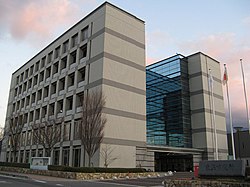
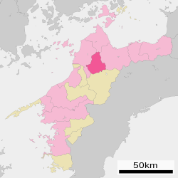
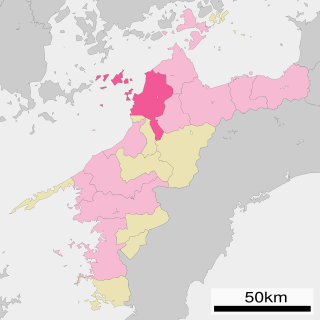
Ehime Prefecture is a prefecture of Japan located on the island of Shikoku. Ehime Prefecture has a population of 1,334,841 and has a geographic area of 5,676 km2. Ehime Prefecture borders Kagawa Prefecture to the northeast, Tokushima Prefecture to the east, and Kōchi Prefecture to the southeast.

<span class="mw-page-title-main">Uwajima, Ehime</span> City in Shikoku, Japan

Uwajima is a city located in Ehime Prefecture, Japan. As of 1 September 2022, the city had an estimated population of 70,440 in 35429 households and a population density of 150 persons per km2. The total area of the city is 468.19 square kilometres (180.77 sq mi).

<span class="mw-page-title-main">Yawatahama</span> City in Ehime Prefecture, Japan

Yawatahama is a city located in of Ehime Prefecture, Japan. As of 31 August 2022, the city had an estimated population of 31,385 in 15,638 households and a population density of 240 persons per km2. The total area of the city is 132.68 square kilometres (51.23 sq mi).

<span class="mw-page-title-main">Saijō, Ehime</span> City in Shikoku, Japan

Saijō is a city in Ehime Prefecture, Japan. As of 1 September 2022, the city had an estimated population of 106,016 in 58,803 households and a population density of 210 persons per km2. The total area of the city is 509.98 square kilometres (196.90 sq mi).

<span class="mw-page-title-main">Iyo, Ehime</span> City in Shikoku, Japan

Iyo is a city located in Ehime Prefecture, Japan. As of 31 March 2022, the city had an estimated population of 35,888 in 16169 households and a population density of 180 persons per km2. The total area of the city is 194.44 square kilometres (75.07 sq mi).

<span class="mw-page-title-main">Uchiko, Ehime</span> Town in Shikoku, Japan

Uchiko is a town located in Kita District, Ehime Prefecture, Japan. As of 1 September 2023, the town had an estimated population of 15,153 in 7005 households and a population density of 52 persons per km2. The total area of the town is 299.43 square kilometres (115.61 sq mi).

<span class="mw-page-title-main">Matsuno, Ehime</span> Town in Shikoku, Japan

Matsuno is a town located in Kitauwa District, Ehime Prefecture, Japan. As of 1 September 2022, the town had an estimated population of 3,693 in 1978 households, and a population density of 38 persons per km². The total area of the town is 98.45 square kilometres (38.01 sq mi).

<span class="mw-page-title-main">Shikokuchūō</span> City in Shikoku, Japan

Shikokuchūō is a city located in Ehime Prefecture, Japan. As of August 31, 2022, the city had an estimated population of 83,635 in 28876 households and a population density of 200 persons per km². The total area of the city is 421.24 square kilometres (162.64 sq mi). Shikokuchūō is the leading producer of paper and paper products in Japan. It is also a port city and one of Ehime's major centers of industry.

<span class="mw-page-title-main">Seiyo, Ehime</span> City in Shikoku, Japan

Seiyo is a city located in Ehime Prefecture, Japan. As of 31 August 2022, the city had an estimated population of 35,456 in 17627 households and a population density of 69 persons per km². The total area of the city is 514.34 square kilometres (198.59 sq mi).

<span class="mw-page-title-main">Kumakōgen, Ehime</span> Town in Shikoku, Japan

Kumakōgen is a town in Kamiukena District, Ehime Prefecture, Japan. As of 1 August 2023, the town had an estimated population of 6,667 and a population density of about 11.4 persons per km2. The total area of the town is 583.69 square kilometres (225.36 sq mi).

National Route 11 is a Japanese highway on the island of Shikoku. The most important artery in Shikoku, it originates at the intersection with Routes 28, 55 and 195 in the prefectural capital of Tokushima and terminates at the intersection with Routes 33, 56, 317, 379, 440 and 494 in Matsuyama. Between the terminals, it passes through Naruto and Takamatsu, as well as other regional population centers. Route 11 measures 239.4 km in length.

<span class="mw-page-title-main">Imabari, Ehime</span> City in Shikoku, Japan

Imabari is a city in Ehime Prefecture, Japan. It is the second largest city in the prefecture. As of 31 August 2022, the city had an estimated population of 152,111 in 75,947 households and a population density of 360 persons per km². The total area of the city is 468.19 square kilometres (180.77 sq mi). The population is the second largest in Ehime Prefecture after Matsuyama City.

<span class="mw-page-title-main">Niihama</span> City in Shikoku, Japan

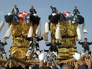
Niihama is a city located in the eastern part of Ehime Prefecture, Japan. As of 31 July 2022, the city had an estimated population of 115,824 in 57781 households and a population density of 490 persons per km². The total area of the city is 234.50 square kilometres (90.54 sq mi). It has the third largest population in Ehime, behind the prefectural capital of Matsuyama and the recently expanded city of Imabari. It is famous for its Besshi copper mine as well as the annual Niihama Taiko Festival that is the center of annual drunken and boisterous activity and draws tourists from around the country.

<span class="mw-page-title-main">Imabari Station</span> Railway station in Imabari, Ehime Prefecture, Japan

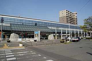
Imabari Station is a passenger railway station located in the city of Imabari, Ehime Prefecture, Japan. It is operated by JR Shikoku and has the station number "Y36".

<span class="mw-page-title-main">Ehime Prefectural Matsuyama Central Senior High School</span> Public high school in Japan

Ehime Prefectural Matsuyama Central Senior High School, abbreviated as Matsuyama Chuo or MCHS or MCH, is a public high school located in Ido-machi, Matsuyama, Ehime, Shikoku, Japan established in 1986 and opened in 1987 as the newest prefectural academic high school in Ehime Prefecture.

<span class="mw-page-title-main">Yokogawara Line</span> Railway line in Ehime Prefecture, Japan

The Yokogawara Line is a 13.2 km railway line owned by Iyotetsu. The line connects Matsuyama with Tōon in Ehime Prefecture, Japan. The line runs eastwards from Matsuyama City Station, terminating at Yokogawara Station.

<span class="mw-page-title-main">Aidai Igakubu Minamiguchi Station</span> Railway station in Tōon, Ehime Prefecture, Japan

Aidai Igakubu Minamiguchi Station is a passenger railway station in the city of Tōon, Ehime Prefecture, Japan. It is on the Yokogawara Line, operated by Iyotetsu.

<span class="mw-page-title-main">Minara Station (Ehime)</span> Railway station in Tōon, Ehime Prefecture, Japan

Minara Station is a passenger railway station in the city of Tōon, Ehime Prefecture, Japan. It is on the Yokogawara Line, operated by Iyotetsu. The station's mascot is a statue of Mazinger Z.

<span class="mw-page-title-main">Tanokubo Station</span> Railway station in Tōon, Ehime Prefecture, Japan

Tanokubo Station is a passenger railway station in the city of Tōon, Ehime Prefecture, Japan. It is on the Yokogawara Line, operated by Iyotetsu.

References

  1. "Tōon city official statistics" (in Japanese). Japan.
  2. Government of Japan(Geographical Survey Institute and Japan Coast Guard) (2007). "Gazetteer of Japan 2007" (PDF). Retrieved 2013-07-10.
  3. According to 昭和二十九年十二月九日内閣告示第一号「ローマ字のつづり方」, wikisource:ja:ローマ字のつづり方 (昭和29年内閣告示第1号)
  4. According to 昭和十二年九月二十一日内閣訓令第三号「国語ノローマ字綴方統一ノ件」
  5. "Tohon High School" . Retrieved 2023-05-04.
  6. Tōon climate data
  7. Tōon population statistics
  8. "愛媛県における衆議院議員の選挙区及び定数 - 愛媛県庁公式ホームページ". 愛媛県庁公式ホームページ (in Japanese). 2024-10-23. Retrieved 2025-02-01.