
One Tree Hill is a town on the outskirts of Adelaide, South Australia. It is located in the City of Playford.

The City of Playford is a local government area of South Australia in Adelaide's northern suburbs. It was named in recognition of Sir Thomas Playford, who played a part in the development of the area, and was South Australia's premier from 1938–1965. The city covers an area of 345 km2 (133 sq mi), and is home to over 90,000 residents. Playford was the fastest growing local government area in South Australia in the 2010s.

Elizabeth is an outer northern suburb of the Adelaide metropolitan area, South Australia, 24 km north of the Adelaide city centre. It is located in the City of Playford. At the 2016 census, Elizabeth had a population of 1,024.

The Town of Gawler is a local government area located north of Adelaide city centre in South Australia containing Gawler and its suburbs. The corporate town was established in 1857 due to the township's residents' dissatisfaction at being governed by three different district councils.

Napier was an electorate in the South Australian Legislative Assembly in the outer northern suburbs of the Adelaide metropolitan area, including the suburbs of Blakeview, Davoren Park, Elizabeth Downs, Evanston South, Kudla, Munno Para, Smithfield and Smithfield Plains, parts of Craigmore, Evanston Park and Munno Para Downs; as well as semi-rural Bibaringa, One Tree Hill, Sampson Flat, Uleybury and Yattalunga, and part of Humbug Scrub.
Taylor is a single-member electoral district for the South Australian House of Assembly. This district is named after Doris Irene Taylor MBE, a leading force in the founding of Meals on Wheels, and Labor activist. Taylor is a 246.2 km2 semi-urban electorate in Adelaide's outer northern suburbs and market gardens on the Adelaide Northern plains. A large portion of the district lives in the western half of the City of Playford and it is regarded as a safe Labor seat. It now includes the suburbs and townships of Andrews Farm, Angle Vale, Bolivar, Buckland Park, Davoren Park, Edinburgh, Edinburgh North, Elizabeth North, Eyre, Macdonald Park, Munno Para West, Penfield, Penfield Gardens, Riverlea Park, Smithfield, Smithfield Plains, St Kilda, Virginia, and Waterloo Corner.
News Review Messenger is a weekly suburban newspaper in Adelaide, South Australia, part of the Messenger Newspapers group. The News Review's area stretches from Pooraka in the south, through to Gawler in the north, and covers Adelaide's northern suburbs.
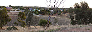
Craigmore is a large suburb north of Adelaide, South Australia. It is in the City of Playford local government area, just east of Elizabeth and south of Gawler.
Smithfield is a suburb in the northern outskirts of Adelaide, South Australia. It is in the City of Playford.

Salisbury is a northern suburb of Adelaide, South Australia. It is the seat of the City of Salisbury, and in the South Australian Legislative Assembly electoral district of Ramsay and the Australian House of Representatives division of Spence. The suburb is a service area for the City of Salisbury district, with many parklands, shops, cafés and restaurants.

The City of Elizabeth was a local government area located in the northern suburbs of Adelaide and seated at Elizabeth from 1964 to 1997.
The City of Munno Para, formerly the District Council of Munno Para, was a local government area of South Australia from 6 November 1958 to 1997, seated at the township of Smithfield. In 1997 the City of Munno Para merged with the City of Elizabeth to form the new City of Playford.
Munno Para is a northern suburb of Adelaide, South Australia. It is located in the City of Playford.

Angle Vale is a semi-rural town on the Adelaide Plains between Gawler and Virginia in South Australia. It is steadily being surrounded by Adelaide's suburban sprawl. It is close to many vineyards and farms. The town includes Trinity College's Gawler River campus, Angle Vale Primary School and Riverbanks College. Some students travel to nearby towns or to Gawler.
Penfield is a northern suburb of Adelaide, South Australia, in the City of Playford.

The Hundred of Munno Para is a cadastral unit of hundred covering the outer northern suburbs of Adelaide north of the Little Para River and the flanking semi-rural areas in South Australia. It is one of the eleven hundreds of the County of Adelaide. It was named in 1846 by Governor Frederick Robe, Munno Para being a term from a local Kaurna Aboriginal people meaning golden wattle creek. This name refers to either the Gawler River or the Little Para River.
King is a single-member electoral district for the South Australian House of Assembly. It was created by the redistribution conducted in 2016, and was contested for the first time at the 2018 state election.
Daniel Garlick was an architect in the early days of South Australia. During his lifetime, his architectural practice names were Garlick & Son and Jackman & Garlick. After his death his name was perpetuated by two rival firms: Garlick & Sibley and then Garlick, Sibley & Wooldridge; and Garlick & Jackman and then Garlick, Jackman & Gooden.
The District Council of Munno Para East was a local government area of South Australia from 1853 to 1958, seated at Uleybury.
The District Council of Munno Mara West was a local government area of South Australia on the central Adelaide Plains from 1854 to 1933.

