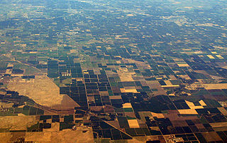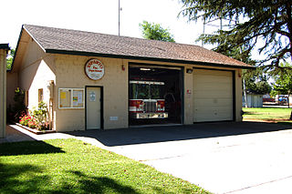
Tulare County is a county located in the U.S. state of California. As of the 2020 census, the population was 473,117. The county seat is Visalia. The county is named for Tulare Lake, once the largest freshwater lake west of the Great Lakes. Drained for agricultural development, the site is now in Kings County, which was created in 1893 from the western portion of the formerly larger Tulare County.

The Central Valley is a broad, elongated, flat valley that dominates the interior of California. It is 40–60 mi (60–100 km) wide and runs approximately 450 mi (720 km) from north-northwest to south-southeast, inland from and parallel to the Pacific coast of the state. It covers approximately 18,000 sq mi (47,000 km2), about 11% of California's land area. The valley is bounded by the Coast Ranges to the west and the Sierra Nevada to the east.

Lemoore is a city in Kings County, California, United States. Lemoore is located 7.5 miles (12 km) west-southwest of Hanford, at an elevation of 230 feet (70 m). It is part of the Hanford-Corcoran Metropolitan Statistical Area. The population was 24,531 at the 2010 Census. The California Department of Finance estimated that Lemoore's population was 26,725 on July 1, 2019.

Tulare is a city in Tulare County, California. The population was 68,875 per the 2020 census. It is located in the heart of the San Joaquin Valley, 8 mi (13 km) south of Visalia and 60 mi (97 km) north of Bakersfield. The city is named after the Tulare Lake, once the largest freshwater lake west of the Great Lakes.

Visalia is a city in the agricultural San Joaquin Valley of California. The population was 141,384 as per the 2020 census. Visalia is the fifth-largest city in the San Joaquin Valley, the 42nd most populous in California, and 192nd in the United States. As the county seat of Tulare County, Visalia serves as the economic and governmental center to one of the most productive agricultural counties in the country.

Esparto is a census-designated place (CDP) in Yolo County, California, United States. It is part of the Sacramento–Arden-Arcade–Roseville Metropolitan Statistical Area. The population was 3,108 at the 2010 census.

Tulare Lake or Tache Lake is a freshwater lake in the southern San Joaquin Valley, California, United States. Historically, Tulare Lake was once the largest freshwater lake west of the Mississippi River, and the second-largest freshwater lake entirely in the United States based upon surface area. For thousands of years, from the Paleolithic onward, Tulare Lake was a uniquely rich area, which supported perhaps the largest population of Native Americans north of Mexico.

The San Joaquin Valley is the southern half of California's Central Valley, an area drained by the San Joaquin River. Praised as a breadbasket, the San Joaquin Valley is a major source of food, producing a significant part of California's agricultural output.

Central California is generally thought of as the middle third of the U.S. state, of California, north of Southern California, which includes Los Angeles, and south of Northern California, which includes San Francisco. It includes the northern portion of the San Joaquin Valley, part of the Central Coast, the central hills of the California Coast Ranges and the foothills and mountain areas of the central Sierra Nevada.

The San Joaquin Valley Railroad is one of several short line railroad companies and is part of the Western Region Division of Genesee & Wyoming Inc. It operates over about 371 miles (597 km) of owned or leased track primarily on several lines in California's Central Valley/San Joaquin Valley around Fresno and Bakersfield. The SJVR has trackage rights over Union Pacific between Fresno, Goshen, Famoso, Bakersfield and Algoso. The SJVR also operated for the Tulare Valley Railroad (TVRR) from Calwa to Corcoran and Famoso.

The Kaweah River is a river draining the southern Sierra Nevada in Tulare County, California in the United States. Fed primarily by high elevation snowmelt along the Great Western Divide, the Kaweah begins as four forks in Sequoia National Park, where the watershed is noted for its alpine scenery and its dense concentrations of giant sequoias, the largest trees on Earth. It then flows in a southwest direction to Lake Kaweah – the only major reservoir on the river – and into the San Joaquin Valley, where it diverges into multiple channels across an alluvial plain around Visalia. With its Middle Fork headwaters starting at almost 13,000 feet (4,000 m) above sea level, the river has a vertical drop of nearly two and a half miles (4.0 km) on its short run to the San Joaquin Valley, making it one of the steepest river drainages in the United States. Although the main stem of the Kaweah is only 33.6 miles (54.1 km) long, its total length including headwaters and lower branches is nearly 100 miles (160 km).
The Tulare Valley Railroad was operational from December 22, 1992 after acquiring several former Santa Fe Railway branch lines in California's San Joaquin Valley on October 20, 1992. The company was formed by Morris Kulmer & Kern Schumucher and Michael Van Wagenen of Kyle Railways. A&K Railroad Materials specializes in dismantling railroad lines and selling relay (used) track materials. Kyle Railways operates several shortline railroads throughout the United States.
There are 45 routes assigned to the "J" zone of the California Route Marker Program, which designates county routes in California. The "J" zone includes county highways in Alameda, Calaveras, Contra Costa, Fresno, Kern, Inyo, Mariposa, Merced, Sacramento, San Benito, San Joaquin, Stanislaus, and Tulare counties.
Angiola is an unincorporated community in Tulare County, California, United States. Angiola is located on California State Route 43 13 miles (21 km) west-northwest of Earlimart, along the route of the San Francisco and San Joaquin Valley Railroad which became part of the Atchison, Topeka and Santa Fe Railway Valley Division. The community was named after Angela Bacigalupi, wife of a landowner there. Angiola had a post office from 1898 to 1927.
The White River is a small river in the southern San Joaquin Valley of the U.S. state of California. The river is 50.7 miles (81.6 km) long and flows entirely within Tulare County. It rises at roughly 6,800 feet (2,100 m) above sea level in the foothills of the Sierra Nevada on the northwest slope of Bull Run Peak. It flows west, receiving several seasonal tributaries including Arrastre Creek, Coarse Gold Creek and Coho Creek, passing the small settlement of White River. As it nears the border of Tulare County and Kern County its surface flow disappears. The dry riverbed continues northwest into the agricultural San Joaquin Valley and is diverted into canals for flood control and irrigation purposes. The river terminates about 5 miles (8.0 km) north of Delano, short of the historic Tulare Lake.
Poso Creek or Posey Creek is an 87.9-mile (141.5 km) intermittent stream in Kern County, California.
Blanco is an unincorporated community in Tulare County, California, United States. Blanco is located along California State Route 43 and the BNSF Railroad 5.1 miles (8.2 km) southeast of Corcoran.
Kings–Tulare Regional Station is a planned California High-Speed Rail station serving Kings County and Tulare County, California. It will be located near the intersection of Hanford Expressway and Central Valley Highway, just east of the city limits of Hanford and less than 20 miles (32 km) west of the larger city of Visalia. The construction of the station has been controversial, with Tulare County supporting the station while Kings County, where the station would be located, has strongly opposed the entire California High-Speed Rail project.
The Cross Valley Corridor is a proposed passenger rail service in the California Central Valley, connecting Visalia, Hanford, Porterville, and surrounding cities to each other and California High-Speed Rail's planned Kings–Tulare Regional Station.

Millwood was a lumber boomtown located in present-day Sequoia National Forest near Converse Basin Grove in California. It was established in 1891 by the Kings River Lumber Company and was connected to the Sequoia Railroad, which brought logs to the town to be turned into rough lumber. The lumber was then transported by log flume to Sanger, a journey of 54 miles. At its peak, Millwood had a population of over 2,000 people and featured two hotels, a summer school, and a post office. However, today there are no remaining structures or buildings at the Millwood site.


