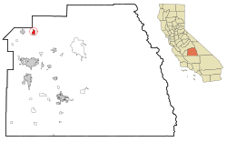
Orosi, California

Last updated

Orosi
Tulare County California Incorporated and Unincorporated areas Orosi Highlighted.svg
Location in Tulare County and the state of California
Usa edcp location map.svg
Red pog.svg
Orosi
Location in the United States
Coordinates: 36°32′33″N119°17′20″W / 36.54250°N 119.28889°W / 36.54250; -119.28889
Country Flag of the United States.svg  United States
State Flag of California.svg  California
County Tulare
Area
[1]
  Total2.446 sq mi (6.334 km2)
  Land2.446 sq mi (6.334 km2)
  Water0 sq mi (0 km2)  0%
Elevation
[2]
374 ft (114 m)
Population
 (2010)
  Total8,770
  Density3,600/sq mi (1,400/km2)
Time zone UTC-8 (Pacific (PST))
  Summer (DST) UTC-7 (PDT)
ZIP code
93647
Area code 559
FIPS code 06-54372
GNIS feature IDs 230107, 2409000

Orosi is a census-designated place (CDP) in Tulare County, California, United States. The population was 8,770 at the 2010 census, up from 7,318 at the 2000 census.

Contents

History

The community was founded in 1888 by Daniel R. Shafer. It was named "oro," or gold, for the golden poppies covering the nearby fields. A post office was established in 1892. [3]

Geography

According to the United States Census Bureau, the CDP has a total area of 2.4 square miles (6.2 km2), all of it land.

Demographics

2010

The 2010 United States Census [4] reported that Orosi had a population of 8,770. The population density was 3,586.2 inhabitants per square mile (1,384.6/km2). The racial makeup of Orosi was 3,861 (44.0%) White, 65 (0.7%) African American, 57 (0.6%) Native American, 803 (9.2%) Asian, 1 (0.0%) Pacific Islander, 3,638 (41.5%) from other races, and 345 (3.9%) from two or more races. Hispanic or Latino of any race were 7,606 persons (86.7%).

The Census reported that 8,770 people (100% of the population) lived in households, 0 (0%) lived in non-institutionalized group quarters, and 0 (0%) were institutionalized.

There were 1,985 households, out of which 1,285 (64.7%) had children under the age of 18 living in them, 1,180 (59.4%) were opposite-sex married couples living together, 375 (18.9%) had a female householder with no husband present, 197 (9.9%) had a male householder with no wife present. There were 196 (9.9%) unmarried opposite-sex partnerships, and 7 (0.4%) same-sex married couples or partnerships. 167 households (8.4%) were made up of individuals, and 85 (4.3%) had someone living alone who was 65 years of age or older. The average household size was 4.42. There were 1,752 families (88.3% of all households); the average family size was 4.50.

The population was spread out, with 3,086 people (35.2%) under the age of 18, 1,083 people (12.3%) aged 18 to 24, 2,397 people (27.3%) aged 25 to 44, 1,552 people (17.7%) aged 45 to 64, and 652 people (7.4%) who were 65 years of age or older. The median age was 26.4 years. For every 100 females, there were 107.0 males. For every 100 females age 18 and over, there were 108.1 males.

There were 2,070 housing units at an average density of 846.5 per square mile (326.8/km2), of which 1,118 (56.3%) were owner-occupied, and 867 (43.7%) were occupied by renters. The homeowner vacancy rate was 2.6%; the rental vacancy rate was 3.7%. 4,928 people (56.2% of the population) lived in owner-occupied housing units and 3,842 people (43.8%) lived in rental housing units.

2000

As of the census [5] of 2000, there were 7,318 people, 1,678 households, and 1,461 families residing in the CDP. The population density was 2,984.4 inhabitants per square mile (1,152.3/km2). There were 1,741 housing units at an average density of 710.0 per square mile (274.1/km2). The racial makeup of the CDP was 29.42% White, 0.36% African American, 0.92% Native American, 10.21% Asian, 0.03% Pacific Islander, 53.53% from other races, and 5.55% from two or more races. Hispanic or Latino of any race were 81.99% of the population.

There were 1,678 households, out of which 53.5% had children under the age of 18 living with them, 64.4% were married couples living together, 15.1% had a female householder with no husband present, and 12.9% were non-families. 10.0% of all households were made up of individuals, and 6.7% had someone living alone who was 65 years of age or older. The average household size was 4.36 and the average family size was 4.49.

In the CDP, the population was spread out, with 35.8% under the age of 18, 13.3% from 18 to 24, 28.0% from 25 to 44, 14.8% from 45 to 64, and 8.1% who were 65 years of age or older. The median age was 26 years. For every 100 females, there were 111.8 males. For every 100 females age 18 and over, there were 114.6 males.

The median income for a household in the CDP was $30,400, and the median income for a family was $29,600. Males had a median income of $17,323 versus $19,195 for females. The per capita income for the CDP was $7,928. About 25.2% of families and 30.9% of the population were below the poverty line, including 40.3% of those under age 18 and 8.4% of those age 65 or over.

Arts and culture

Orosi Branch Library 2009-0725-CA-Orosi-library.jpg
Orosi Branch Library

The Orosi Branch Library is listed on the National Register of Historic Places.

Government

In the state legislature Orosi is located in the 16th Senate District, represented by Democrat Dean Florez, and in the 26th Assembly District , represented by Democrat Evan Low. [6]

In the United States House of Representatives, Orosi is in California's 22nd congressional district , represented by Republican David Valadao [7]

Education

The community is served by the Cutler-Orosi Joint Unified School District. Senior students attend Orosi High School.

A campus of the College of the Sequoias is located on Orosi High School grounds.

Notable people

See also

East Orosi, California- though commonly considered merely the east side of Orosi, it is its own CDP with a population of approximately 500.

Related Research Articles

<span class="mw-page-title-main">Laton, California</span> Census-designated place in California, United States

Laton is a census-designated place (CDP) in Fresno County, California, United States. The population was 1,824 at the 2010 census, up from 1,236 at the 2000 census. Laton is located 23 miles (37 km) south-southeast of Fresno, at an elevation of 259 feet.

<span class="mw-page-title-main">South Taft, California</span> Census-designated place in California, United States

South Taft is a census-designated place (CDP) in Kern County, California, United States. South Taft is located 0.5 miles (0.8 km) south of Taft, at an elevation of 1,017 feet (310 m). The population was 2,169 at the 2010 census, up from 1,898 at the time of the 2000 census.

<span class="mw-page-title-main">Desert View Highlands, California</span> Census designated place in California, United States

Desert View Highlands is a census-designated place (CDP) in Los Angeles County, California, United States. The population was 2,360 at the 2010 census, up from 2,337 at the 2000 census. It is surrounded by the City of Palmdale.

<span class="mw-page-title-main">Madera Acres, California</span> Census-designated place in California, United States

Madera Acres is a census-designated place (CDP) in Madera County, California, United States. It is part of the Madera Metropolitan Statistical Area. The population was 9,162 at the 2020 census, virtually unchanged from 2010.

<span class="mw-page-title-main">Parkwood, California</span> Census-designated place in California, United States

Parkwood is a census-designated place (CDP) in Madera County, California, United States. It is part of the Madera Metropolitan Statistical Area. The population was 2,307 at the 2020 census.

<span class="mw-page-title-main">Le Grand, California</span> Census-designated place in California, United States

Le Grand is an unincorporated community and census-designated place (CDP) in Merced County, California, United States. Le Grand is 14 miles (23 km) east-southeast of Merced, the county seat at an elevation of 253 feet (77 m). The population was 1,592 at the 2020 census, down from 1,659 at the 2010 census.

<span class="mw-page-title-main">C-Road, California</span> Census-designated place in California, United States

C-Road is a census-designated place (CDP) in Plumas County, California, United States. The population was 150 at the 2010 census, down from 152 at the 2000 census.

<span class="mw-page-title-main">Camp Pendleton Mainside, California</span> Census-designated place in California, United States

Camp Pendleton Mainside is a census-designated place (CDP) in San Diego County, California, located at the southeast corner of the Marine Corps Base Camp Pendleton. Per the 2020 census, the population was 9,683. It was formerly known as Camp Pendleton North, but its name was changed for the 2020 Census. Along with Camp Pendleton South, it is one of two CDPs located on the base.

<span class="mw-page-title-main">La Presa, California</span> Census-designated place in California, United States

La Presa is a census-designated place (CDP) in the East County region of San Diego County, California, United States. The population was 34,169 at the 2010 census, up from 32,721 at the 2000 census.

<span class="mw-page-title-main">Taft Mosswood, California</span> Census-designated place in California, United States

Taft Mosswood is a census-designated place (CDP) in San Joaquin County, California, United States. The population was 1,530 at the 2010 census, up from 1,388 at the 2000 census. It comprises an unincorporated "island" within the City of Stockton.

<span class="mw-page-title-main">Cutler, California</span> Census-designated place in California, United States

Cutler is a community and census-designated place (CDP) in Tulare County, California, United States. The population was 5,000 at the 2010 census, up from 4,491 at the 2000 census. The population as of 2019 was 5,214.

<span class="mw-page-title-main">Ducor, California</span> Census-designated place in California, United States

Ducor is a census-designated place (CDP) in Tulare County, California, United States. The population was 616 at the 2020 census, up from 612 at the 2010 census. Ducor is an abbreviation of an earlier name, Dutch Corners, which was given because several early settler families were German. The word "Dutch" in this case derives from German deutsch "German".

<span class="mw-page-title-main">East Orosi, California</span> Place in California, United States

East Orosi is an unincorporated community in Tulare County, California, United States. The population was 495 at the 2010 census, up from 426 in 2000. For statistical purposes, the United States Census Bureau has defined East Orosi as a census-designated place (CDP).

<span class="mw-page-title-main">Goshen, California</span> Census-designated place in California, United States

Goshen is a census-designated place (CDP) near Visalia, in Tulare County, California, United States. The population was at 5,387 in the 2020 census, up from the 3,006 in the 2010 census. Until the twentieth century, Goshen was an island in a marsh at the edge of Tulare Lake, formerly the largest freshwater lake west of the Great Lakes until drained.

<span class="mw-page-title-main">Poplar-Cotton Center, California</span> Census-designated place in California, United States

Poplar-Cotton Center is a census-designated place (CDP) in Tulare County, California, United States. The population was 2,470 at the 2010 census, up from 1,496 at the 2000 census.

<span class="mw-page-title-main">Richgrove, California</span> Census-designated place in California, United States

Richgrove is a census-designated place (CDP) in Tulare County, California, United States. The population was 2,358 at the 2020 United States census, down from 2,882 at the 2010 census.

<span class="mw-page-title-main">Strathmore, California</span> Census-designated place in California, United States

Strathmore is a census-designated place (CDP) in Tulare County, California, United States. The population was 2,819 at the 2010 census, up from 2,584 at the 2000 census.

<span class="mw-page-title-main">Woodville, California</span> Census-designated place in California, United States

Woodville is a census-designated place (CDP) in Tulare County, California, United States. The population was 1,740 at the 2010 census, up from 1,678 at the 2000 census.

<span class="mw-page-title-main">Sharon (CDP), Massachusetts</span> CDP in Massachusetts, United States

Sharon is a census-designated place (CDP) in the town of Sharon in Norfolk County, Massachusetts, United States. The population was 6,184 at the 2020 census.

<span class="mw-page-title-main">Hartland, California</span> Census-designated place in California, United States

Hartland is a census-designated place (CDP) in Tulare County, California, United States. Hartland sits at an elevation of 4,475 feet (1,364 m). The 2010 United States census reported Hartland's population was 30.

References

  1. "2010 Census U.S. Gazetteer Files – Places – California". United States Census Bureau.
  2. "Orosi". Geographic Names Information System . United States Geological Survey, United States Department of the Interior . Retrieved November 18, 2014.
  3. Gudde, Erwin Gustav (1969). California Place Names: A Geographical Dictionary. University of California Press.
  4. "2010 Census Interactive Population Search: CA - Orosi CDP". U.S. Census Bureau. Archived from the original on July 15, 2014. Retrieved July 12, 2014.
  5. "U.S. Census website". United States Census Bureau . Retrieved January 31, 2008.
  6. "Statewide Database". UC Regents. Archived from the original on February 1, 2015. Retrieved November 18, 2014.
  7. "California's 22nd Congressional District - Representatives & District Map". Civic Impulse, LLC. Retrieved October 6, 2014.