Umunneochi Nneochi Umunneochi | |
---|---|
Country | Nigeria |
State | Abia State |
Capital | Nkwoagu |
Government | |
• Type | Democracy |
Area | |
• Total | 142 sq mi (368 km2) |
Population (2006) | |
• Total | 163,928 |
Time zone | UTC+1 (WAT) |
Lua error in Module:Mapframe at line 384: attempt to perform arithmetic on local 'lat_d' (a nil value). |
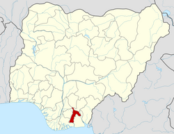
Umu-Nneochi or Umunneochi is a Local Government Area (LGA) in Abia State, Nigeria.
Officially known as "Nneochi", Umunneochi is made up of three major septs: Umuchieze, Nneato, and Isuochi. The major towns of Umunneochi are Umuelem, Ndiawa, Amuda, Umuaku, Achara, Lomara, Ngodo-ukwu, Lokpaukwu, Leru, Lomara Lokpanta, Lekwesi and Mbala.[ citation needed ] These towns have been repeatedly reorganized. The paramount traditional ruler of isuochi is Eze G I Ezekwesiri, the Ochi 1 of Isuochi, while the federating autonomous communities are governored by Ndi-Eze.[ citation needed ]
Umunneochi headquarters is in the administrative town of Nkwoagu, Isuochi. Nkwoagu is also the administrative capital, which in ancient and modern times were political and administrative rallying points for the Umunneochi autonomous communities.[ citation needed ]
Umunneochi occupies 368 km2 with a population of 163,928, according to the 2006 Nigeria National Census.
The major occupations include agriculture and granite, quorite, and laterite mining and trading. The main agricultural food crops are cassava, yam, black beans, and cocoyam. The cash crops are palm nuts and cashew nuts. Pottery is another occupation. Nigeria's biggest cattle market is in the Lokpanta area. [1]
The cultivation of agricultural food crops such cassava, yam, black beans, cocoyam, as well as black-smitting, is the main occupation within the local government. Additionally, they take part in regional stone mining activities with a focus on stones, clay, and pottery production. [2]
With a total area of 368 square kilometers and an average temperature of 27 degrees Celsius, Umunneochi LGA is quite large. The LGA experiences two distinct seasons, the dry and the wet, with an estimated average wind speed of 10 km/h. It has a normal tropical climate with two distinct seasons. [3]
Spiritan University [4] owned by the Catholic Church is located in Ngodo Isuochi in Umunneochi LGA. There are also other public and private schools in the local government.
Ihiala is a city in Nigeria, located in the southern part of Anambra State and within the region known as Igboland. It has long served as the local administrative capital of Ihiala Local Government Area. The Local Government Area has a population of about 87,796.
Okigwe is the third largest city in Imo state in Nigeria after Owerri and Orlu. Okigwe is located in the Okigwe Local Government Area of Nigeria. The city lies between the Port Harcourt-Enugu-Maiduguri rail line, being the nearest city to the biggest cattle market in Nigeria located in the Umu Nneochi Area of Abia state. Thus, the city has grown into a major cattle transit town for the southeast and south subregions of Nigeria. Okigwe has a population of 132,237. Most of the population is made up of immigrant workers from other states. Okigwe city was the primary host site of the old Imo State University. Okigwe has various tourist and historical sites. The Federal Government College in the city has remained one of the best unity schools in Nigeria. Okigwe remains one of the breadbaskets of Nigeria with terrace cultivation practised on its hilly farmlands. Okigwe also boasts many relaxation spots such as Alexandra Suites & Hotels Limited Okigwe Imo state which is situated at No 1 Alexandra Ave, Umuchima Road, Ubahu. St. Mary's Cathedral in Okigwe is the seat of the Roman Catholic Diocese of Okigwe. In 2016, the Imo state government recommissioned a new cattle market in the city in respect to the previous one that has been relocated to Abia.
The Aro people or Aros are an Igbo subgroup that originated from the Arochukwu kingdom in present-day Abia state, Nigeria. The Aros can also be found in about 250 other settlements mostly in the Southeastern Nigeria and adjacent areas. The Aros today are classified as Eastern or Cross River Igbos because of their location, mixed origins, culture, and dialect. Their god, Chukwu Abiama, was a key factor in establishing the Aro Confederacy as a regional power in the Niger Delta and Southeastern Nigeria during the 18th and 19th centuries.
Awka'Awka South Local Government Area (LGA) is made up of nine towns, namely, Amawbia, Awka, Ezinato, Isiagu, Mbaukwu, Nibo, Nise, Okpuno and Umuawulu. There are three major streets that span this area, which are the Zik Avenue, Works Road and Arthur Eze Avenue. In the past, the people of Awka South LGA were well known for blacksmithing. Today they are respected among the Igbo people of Nigeria for their technical and business skills.
Dunukofia is a Local Government Area in Anambra State, South-East Nigeria. Towns that make up the local government are Ukpo, the headquarters; Ifitedunu, Dunukofia Umunnachi, Umudioka, Ukwulu and Nawgu. It shares boundaries with Awka North, Idemili North, Njikoka and Oyi Local Governments.
Ekwusigo is a Local Government Area in Anambra State, south-central Nigeria. Towns that make up the local government are Ozubulu, Oraifite, Ichi and Ihembosi.
Omor in Ayamelum local government area of Anambra state in Nigeria, is on the shores of the Omambala River. It is made up of the villages of Akanator, Aturia, Amikwe and Orenja.
Etinan is located within the South South part of Nigeria and constitutes one of the Local Government Areas in the oil rich Akwa Ibom State. Known for its agricultural and arts craft products, the area forms one of the most peaceful locations in the West African State of Nigeria.
Awgu is the Headquarters of Awgu Local Government Area (LGA) in Enugu State, Nigeria and the Headquarters of Awgu Catholic Diocese. The Catholic Cathedral is said to resemble a space ship when viewed with Google Earth. The town is also the Orientation Training Centre for National Youth Service corps members posted to Enugu State. Geographically, Awgu LGA is located approximately between latitudes 06 00’ and 06 19’ North of the Equator and longitudes 07 23’ and 07 35’ East of the Greenwich Meridian. Awgu LGA is bounded in the north by Udi and Nkanu West LGAs, in the west by Oji River LGA, Aninri LGA and Ivo LGA of Ebonyi State in the East and share border with umunneochi L.G.A of Abia State in the south. The name of the Traditional ruler is Egbeleli. The market is known as Orie Awgu.
Obingwa is a Local Government Area of Abia State, Nigeria. Its headquarters are in the town of Mgboko.
Ugwunagbo is a local government area of Abia State, Nigeria.
Ukwa West is a Local Government Area in Abia State, Nigeria. Its headquarters is in the town of Oke Ikpe.
Igbo Eze South is a Local Government Area of Enugu State in South East, Nigeria. Its headquarters are in the town of Ibagwa-Aka. The present local government Chairman is Comrade Peter Andy.
Ideato South is a Local Government Area in Imo State, South-eastern Nigeria. Ideato South, with a total of 23 autonomous communities has its headquarters in the town of Dikenafai, the source of Orashi River. Ideato South has an area of 88 km² and a population of 159,879 at the 2006 census. The postal code of the area is 475.
Buruku is a Local Government Area of Benue State, Nigeria. Its headquarters are in the town of Buruku.
The Waawa clan of Northern Igboland, also referred to as Ndi Waawa, Wawa People, are a unique sub-group of the Igbo people in Enugu and Ebonyi State, Nigeria, consisting of several communities, who all speak a unique dialect of Igbo called Waawa. The most notable among these are the Agbaja and Ngwo which consist of peoples between the wooded lands of Awka to the rocky valleys of Enugu. The Agbaja are made up of communities in present-day Ngwo clan, Udi, Ezeagu, Umulokpa, Igbo-Etiti, Oji River, greater Awgu, Odume, Ndiagbor, Nenwe, Mpu, Okpanku and Enugu East Local Government Areas. Other notable parts of the Waawa clan include Nkanu, Nsukka, Abia, Nike, Agbani, Owo, and other communities in Enugu State. The Waawa are most notably associated with Chief Onyeama's people from Eke, who was the paramount ruler of Agbaja in the early 20th century.
Umulokpa is a town in Enugu State, Nigeria. It serves as the headquarters of Uzo-Uwani Local Government Area (L.G.A) in Enugu State, and has a population of over 150,000.
Abayi Okoroato is a city in Obingwa local government area of Abia State, Nigeria.
Umuagbai town is one of the major settlements of the Ndoki people. These towns numbering 54 in total are grouped into seven clans they are Umu Ihueze 1, Umu Ihueze II, Obohia, Ikwueke, Umu Okobo, Ohuru and Mkporobo and Ikwu-Orie-Ato. Umuagbai town is located presently in Oyigbo Local Government Area of Rivers State and is part of the Umu Okobo clan. Umuagbai town is one of the larger communities within the local government area and constitutes an entire Ward on its own; Ward Six. Umuagbai town shares boundary with Akwete in Abia State and the two communities has strong cultural affinities. It is bounded to the south by Azuogu and to the north by Mgboji all in Oyigbo L.G.A while its boundary in the west is to Okwali in Khana Local Government of Rivers State.
Nchara is an agrarian community in Oloko, Ikwuano Local Government Area, Abia State, Nigeria. It is composed of two sister villages namely; Akanu and Etoruo. Afa Ukwu is the autonomous community of Nchara. It is about 24 km away from the state capital, Umuahia.
5°59′09″N7°24′08″E / 5.9857°N 7.4023°E