Unicorn Peak

Last updated
Unicorn Peak
Unicorn Peak Mount Rainier National Park 2016.jpg
Highest point
Elevation 6,971 ft (2,125 m) [1]
Prominence 2,091 ft (637 m) [1]
Parent peak Mount Rainier [2]
Isolation 4.72 mi (7.60 km) [2]
Coordinates 46°44′42″N121°42′03″W / 46.745127°N 121.700912°W / 46.745127; -121.700912
Geography
USA Washington relief location map.jpg
Red triangle with thick white border.svg
Unicorn Peak
Location in Washington
CountryUnited States
State Washington
County Lewis
Protected area Mount Rainier National Park
Parent range Tatoosh Range
Cascades
Topo map USGS Tatoosh Lakes
Climbing
Easiest route class 3 climbing [2]

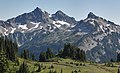
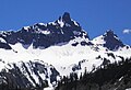
Unicorn Peak is a 6,971-foot (2,125-metre) mountain summit in Lewis County of Washington state, United States. It is the highest point in the Tatoosh Range which is a sub-range of the Cascade Range. [1] It is located in Mount Rainier National Park, south of Mount Rainier. Precipitation runoff from the mountain's small glaciers, such as Unicorn Glacier, drains into tributaries of the Cowlitz River. The descriptive name is for the mountain's resemblance to the head and horn of a unicorn. The toponym was officially adopted in 1913 by the U.S. Board on Geographic Names. [3]

Contents

Climate

Unicorn Peak is located in the marine west coast climate zone of western North America. [4] Most weather fronts originating in the Pacific Ocean travel northeast toward the Cascade Mountains. As fronts approach, they are forced upward by the peaks of the Cascade Range (orographic lift), causing them to drop their moisture in the form of rain or snow onto the Cascades. As a result, the west side of the Cascades experiences high precipitation, especially during the winter months in the form of snowfall. [4] Because of maritime influence, snow tends to be wet and heavy, resulting in avalanche danger. [4] During winter months, weather is usually cloudy, but due to high pressure systems over the Pacific Ocean that intensify during summer months, there is often little or no cloud cover during the summer. [4] Due to its temperate climate and proximity to the Pacific Ocean, areas west of the Cascade Crest very rarely experience temperatures below 0 °F (−18 °C) or above 80 °F (27 °C). [4]

See also

Related Research Articles

<span class="mw-page-title-main">Stevens Peak</span> Mountain in Washington, United States

Stevens Peak is a 6,560-foot (1,999-metre) mountain summit in Lewis County, Washington, United States.

<span class="mw-page-title-main">Ruth Mountain</span> Mountain in Washington (state), United States

Ruth Mountain is a 7,115 ft (2,170 m) Skagit Range summit located two miles south of Hannegan Pass in the North Cascades of Washington state. The name honors Ruth Cleveland, daughter of President Grover Cleveland. This mountain's name was officially adopted in 1952 by the United States Board on Geographic Names. Ruth Mountain is situated on the shared border of North Cascades National Park and the Mount Baker Wilderness, which is part of the Mount Baker-Snoqualmie National Forest. The summit offers views of Mount Shuksan, East Nooksack Glacier, Seahpo Peak, Nooksack Tower, Icy Peak, Mount Sefrit, Mineral Mountain, and the Picket Range. The melting and receding Ruth Glacier on the north slope of Ruth creates the headwaters for the Chilliwack River. Precipitation runoff also finds its way into the Nooksack and Baker Rivers.

<span class="mw-page-title-main">Dege Peak</span> Mountain in Washington (state), United States

Dege Peak is a 7,006-foot summit located in Pierce County of Washington state. It is part of the Sourdough Mountains in Mount Rainier National Park. It was named in 1932 for James Henry Dege, a prominent Tacoma businessman and Captain of the First Regiment National Guard of Washington. His mother was a descendant of President Zachary Taylor.

<span class="mw-page-title-main">Antler Peak (Washington)</span> Mountain in Washington (state), United States

Antler Peak is a 7,017-foot (2,139-metre) summit located in Mount Rainier National Park in Pierce County of Washington state. It is part of the Sourdough Mountains, a subset of the Cascade Range. Antler Peak is situated west of Dege Peak and northeast of Sunrise Historic District, with the Sourdough Ridge Trail traversing the south slope of Antler between the two. Mount Fremont is the nearest higher peak, 1.55 mi (2.49 km) to the west. Precipitation runoff from Antler Peak drains into the White River.

<span class="mw-page-title-main">Seymour Peak</span> Mountain in Washington (state), United States

Seymour Peak is a 6,337-foot-elevation mountain summit located in Mount Rainier National Park in Pierce County of Washington state. It is part of the Cascade Range and is situated southeast of Cayuse Pass and northeast of Shriner Peak. Its nearest higher neighbor is Dewey Peak, 0.79 mi (1.27 km) to the east. Precipitation runoff from Seymour Peak drains into tributaries of the Cowlitz River. Seymour Peak is named after William Wolcott Seymour (1861-1929), mayor of Tacoma, Washington, from 1911 to 1914. He was also a philanthropist, mountaineer, and a contributor to the scouting movement. This landform's toponym was officially adopted in 1932 by the U.S. Board on Geographic Names.

<span class="mw-page-title-main">Marcus Peak</span> Mountain in Washington (state), United States

Marcus Peak is a 6,962-foot (2,122 m) summit located in Mount Rainier National Park in Pierce County of Washington state. It is part of the Sourdough Mountains which are a small subset of the Cascade Range, and it is situated north of Dege Peak. The peak was named in 1932 for Marcus Whitman (1802–1847), an early pioneer and physician. The Whitman Glacier on Little Tahoma also honors him. Access to Marcus Peak is limited due to snow closing the Sunrise Road much of the year. July, August, and September are typically the months when the Sunrise Road is seasonally open for vehicle traffic. The nearest higher peak is Palisades Peak, 0.64 miles (1.03 km) to the north-northeast. Precipitation runoff from Marcus Peak drains into the White River.

<span class="mw-page-title-main">Yakima Peak</span> Mountain in Washington (state), United States

Yakima Peak is a 6,226-ft summit located on the eastern border of Mount Rainier National Park. It is also on the shared border of Pierce County and Yakima County in Washington state. Yakima Peak is situated northwest of Tipsoo Lake and west of Chinook Pass on the crest of the Cascade Range. Yakima Peak is a major triple divide point with precipitation runoff draining into tributaries of the White River, Cowlitz River, and Yakima River. Its nearest higher neighbor is Deadwood Peak, 0.59 mi (0.95 km) to the north. The name Yakima Peak honors the Yakima Tribe of eastern Washington state. From Chinook Pass, a short scramble up a gully on the north side leads to a flat summit with unobstructed views of Mount Rainier and Naches Peak.

<span class="mw-page-title-main">Sluiskin Mountain</span> Mountain in Washington (state), United States

Sluiskin Mountain is a prominent pair of summits located in Mount Rainier National Park in Pierce County of Washington state. It is situated northwest of Burroughs Mountain and is part of the Cascade Range. The higher rocky peak is known as The Chief (7026 ft), and the second peak to the west is known as The Squaw. West of The Squaw are pinnacles called The Papooses. Sluiskin was the native American guide who assisted with the first successful ascent of Mount Rainier by Hazard Stevens and P. B. Van Trump in 1870. Sluiskin Falls within the park also honors him.

<span class="mw-page-title-main">Cowlitz Chimneys</span> Mountains in Washington (state), United States

Cowlitz Chimneys are a group of four rhyolite towers located in Mount Rainier National Park in Pierce County of Washington state. As part of the Cascade Range, the Cowlitz Chimneys are situated southwest of Tamanos Mountain and east of Banshee Peak, all of which are visible from the Sunrise Historic District. The Sarvant Glacier is set on the north aspect of these remnants of a volcanic plug. Cowlitz is the name of several geographical features in Mount Rainier National Park, as well as the state of Washington. The name appeared as early as the Lewis and Clark journals of 1805 when it was written as "Cowliskee" and has the Chinook Jargon meaning of "capturing the medicine spirit".

<span class="mw-page-title-main">Mount Ruth (Washington)</span>

Mount Ruth is an 8,690-foot summit located within Mount Rainier National Park in Pierce County of Washington state. Part of the Cascade Range, Mount Ruth is situated between the Emmons Glacier and the Inter Glacier. Access is via the Glacier Basin Trail. The name of the peak honors Ruth Knapp, daughter of the prospector who built Knapp's Cabin in Glacier Basin below the peak. Precipitation runoff from Mount Ruth drains into the White River.

<span class="mw-page-title-main">Wahpenayo Peak</span> Mountain in Washington (state), United States

Wahpenayo Peak is a 6,231-foot (1,899-metre) mountain summit in Lewis County of Washington state, United States. It is part of the Tatoosh Range which is a sub-range of the Cascade Range. It is located south of Mount Rainier within Mount Rainier National Park. The mountain is named for Wahpenayo, a native American chief who was the father-in-law of Indian Henry. Precipitation runoff on the south and east side of the peak drains into tributaries of the Cowlitz River, whereas the north side drains into tributaries of the Nisqually River.

<span class="mw-page-title-main">Foss Peak</span> Mountain peak in Washington, USA

Foss Peak is a 6,524-foot (1,989-metre) summit in the Tatoosh Range which is a sub-range of the Cascade Range. It is located south of Mount Rainier within Mount Rainier National Park, in Lewis County of Washington state. The peak is named for Thea Foss (1857–1927), who founded the Foss Maritime Company with her husband in 1889. The peak also has an alternate name, Manatee Mountain. The nearest higher neighbor is West Unicorn Peak, 0.79 miles (1.27 km) to the southeast. Precipitation runoff from the mountain drains into tributaries of the Cowlitz River.

<span class="mw-page-title-main">West Unicorn Peak</span> Mountain in Washington (state), United States

West Unicorn Peak is the second-highest point in the Tatoosh Range which is a sub-range of the Cascade Range. It is located south of Mount Rainier within Mount Rainier National Park, in Lewis County of Washington state. The nearest higher peak is Unicorn Peak, 0.17 miles (0.27 km) to the east-northeast. Precipitation runoff and meltwater from the peak's small glacier, Unicorn Glacier, drain into tributaries of the Cowlitz River.

<span class="mw-page-title-main">Buell Peak</span> Mountain in Washington (state), United States

Buell Peak is a small 5,756 ft summit located in Mount Rainier National Park in Pierce County of Washington state. It is part of the Cascade Range and is situated 1.5 miles southwest of Cayuse Pass and 0.53 mile east-southeast of Barrier Peak, which is the nearest higher peak. Precipitation runoff from Buell Peak drains into tributaries of the Cowlitz River. The normal climbing access is from the Owyhigh Lakes Trail. The peak's toponym honors John Latimore Buell who arrived in Orting, Washington, in 1890 and went into the hardware business.

<span class="mw-page-title-main">Pyramid Peak (Pierce County, Washington)</span> Mountain in Washington (state), United States

Pyramid Peak is a 6,937-foot (2,114-metre) mountain summit located in Mount Rainier National Park in Pierce County of Washington state. It is part of the Cascade Range and overlooks Indian Henry's Hunting Ground. It is situated at the base of the Success Cleaver, south of South Tahoma Glacier, and southwest of Pyramid Glacier. The summit provides views of Mount Rainier, Mount Adams, Mount St. Helens, and peaks of the Tatoosh Range. Precipitation runoff from Pyramid Peak drains into Pyramid Creek, Tahoma Creek, and Fishers Horn Pipe Creek, which are all tributaries of the Nisqually River.

<span class="mw-page-title-main">Copper Mountain (Pierce County, Washington)</span> Mountain in Washington (state), United States

Copper Mountain is a 6,302-foot (1,921-metre) mountain summit located in Mount Rainier National Park in Pierce County of Washington state. Part of the Cascade Range, it is situated near the base of the Success Cleaver, overlooking Indian Henry's Hunting Ground. Its nearest neighbor is Iron Mountain 0.3 miles (0.48 km) to the south, and the nearest higher peak is Pyramid Peak, one mile (1.6 km) to the northeast. The summit provides views of Mount Rainier, Mount Adams, Mount St. Helens, and peaks of the Tatoosh Range. Precipitation runoff from Copper Mountain drains into Tahoma Creek and Fishers Horn Pipe Creek, which are both tributaries of the Nisqually River. There were great hopes in the late 1800s that mines on Mount Rainier could be a source of precious metals such as copper, silver, and gold. This landform's toponym was officially adopted in 1932 by the United States Board on Geographic Names.

<span class="mw-page-title-main">Iron Mountain (Pierce County, Washington)</span> Mountain in Washington (state), United States

Iron Mountain is a 6,286-foot (1,916-metre) mountain summit located in Mount Rainier National Park in Pierce County of Washington state. Part of the Cascade Range, it is situated near the base of the Success Cleaver, overlooking Indian Henry's Hunting Ground. The nearest higher neighbor is Copper Mountain, 0.3 miles (0.48 km) to the north. The summit provides views of Mount Rainier, Mount Adams, Mount St. Helens, Mount Wow, and peaks of the Tatoosh Range. Precipitation runoff from Iron Mountain drains into Tahoma Creek, Devils Dream Creek, and Fishers Horn Pipe Creek, which are all tributaries of the Nisqually River. There were great hopes in the late 1800s that mines on Mount Rainier could be a source of precious metals such as copper, silver, and gold. Dark reddish rock found on Iron Mountain was thought to be iron or iron oxide. The toponym was officially adopted in 1932 by the United States Board on Geographic Names.

<span class="mw-page-title-main">Old Desolate</span> Mountain in Washington (state), United States

Old Desolate is a 7,137-foot (2,175 m) multi-summit, ridge-like mountain located in Mount Rainier National Park, in Pierce County of Washington state. It is part of the Cascade Range, and lies five miles (8.0 km) due north of the summit of Mount Rainier. The Wonderland Trail provides an approach to this mountain, and the summit offers views of Sluiskin Mountain and Mount Rainier. Burroughs Mountain is the nearest higher neighbor, 2.37 mi (3.81 km) to the southeast. Precipitation runoff from Old Desolate drains east into the West Fork White River, or west into the Carbon River.

<span class="mw-page-title-main">Goat Island Mountain</span> Mountain in Washington (state), United States

Goat Island Mountain is a 7,288-foot (2,221 m) ridge-like mountain located in Mount Rainier National Park, in Pierce County of Washington state. It is part of the Cascade Range, and lies 5.76 mi (9.27 km) east-northeast of the summit of Mount Rainier. This mountain is quite visible from the Sunrise Historic District and the many trails surrounding the Sunrise area. The Wonderland Trail provides an approach to this mountain, and the summit offers views of Cowlitz Chimneys, Fryingpan Glacier, and Mount Rainier. Burroughs Mountain is its nearest higher neighbor, 2.51 mi (4.04 km) to the northwest. Precipitation runoff from Goat Island Mountain drains into the White River. The mountain's descriptive name derives from mountain goats that were often seen on the peak. The toponym was officially adopted in 1932 by the United States Board on Geographic Names.

<span class="mw-page-title-main">Mother Mountain (Washington)</span> Mountain in Washington (state), United States

Mother Mountain is a 6,480+ ft multi-summit, 3-mile long ridge-like mountain located in Mount Rainier National Park, in Pierce County of Washington state. It is part of the Cascade Range, and lies 7 mi (11 km) northwest of the summit of Mount Rainier. The Wonderland Trail provides one approach option to this mountain, and the summit offers views of Mount Rainier. East Fay Peak is its nearest higher neighbor, 0.42 mi (0.68 km) to the south. Precipitation runoff from Mother Mountain is drained by Cataract Creek on the south side of the mountain, and Ipsut Creek drains the north side of it, and both are tributaries of the Carbon River. The west side drains into Mowich Lake, and thence Mowich River.

References

  1. 1 2 3 "Unicorn Peak, Washington". Peakbagger.com. Retrieved 2020-05-25.
  2. 1 2 3 "Unicorn Peak - 6,942' WA". listsofjohn.com. Retrieved 2024-04-14.
  3. "Unicorn Peak". Geographic Names Information System . United States Geological Survey, United States Department of the Interior . Retrieved 2020-02-24.
  4. 1 2 3 4 5 Beckey, Fred W. Cascade Alpine Guide, Climbing and High Routes. Seattle, WA: Mountaineers Books, 2008.