Fremont is a city in Alameda County, California, United States. Located in the East Bay region of the Bay Area, Fremont has a population of 230,504 as of 2020, making it the fourth most populous city in the Bay Area, behind San Jose, San Francisco, and Oakland. It is the closest East Bay city to the high-tech Silicon Valley network of businesses, and has a strong tech industry presence.

Japantown is a neighborhood in the Western Addition district of San Francisco, California.

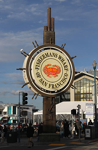
Fisherman's Wharf is a neighborhood and popular tourist attraction in San Francisco, California, United States. It roughly encompasses the northern waterfront area of San Francisco from Ghirardelli Square or Van Ness Avenue east to Pier 35 or Kearny Street. The F Market streetcar runs through the area, the Powell-Hyde cable car line runs to Aquatic Park, at the edge of Fisherman's Wharf, and the Powell-Mason cable car line runs a few blocks away.

Hayes Valley is a neighborhood in the Western Addition district of San Francisco, California. It is located between the historical districts of Alamo Square and the Civic Center. Victorian, Queen Anne, and Edwardian townhouses are mixed with high-end boutiques, restaurants, and public housing complexes. The neighborhood gets its name from Hayes Street, which was named for Thomas Hayes, San Francisco's county clerk from 1853 to 1856 who also started the first Market Street Railway franchise.

Pacific Heights is a neighborhood in San Francisco, California. It has panoramic views of the Golden Gate Bridge, San Francisco Bay, the Palace of Fine Arts, Alcatraz, and the Presidio.

The Port of San Francisco is a semi-independent organization that oversees the port facilities at San Francisco, California, United States. It is run by a five-member commission, appointed by the Mayor and approved by the Board of Supervisors. The Port is responsible for managing the larger waterfront area that extends from the anchorage of the Golden Gate Bridge, along the Marina district, all the way around the north and east shores of the city of San Francisco including Fisherman's Wharf and the Embarcadero, and southward to the city line just beyond Candlestick Point. In 1968 the State of California, via the California State Lands Commission for the State-operated San Francisco Port Authority, transferred its responsibilities for the Harbor of San Francisco waterfront to the City and County of San Francisco / San Francisco Harbor Commission through the Burton Act AB2649. All eligible State port authority employees had the option to become employees of the City and County of San Francisco to maintain consistent operation of the Port of San Francisco.

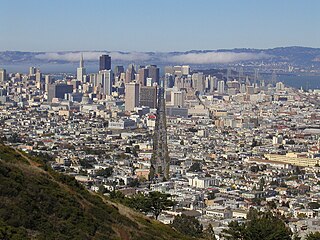
Market Street is a major thoroughfare in San Francisco, California. It begins at The Embarcadero in front of the Ferry Building at the northeastern edge of the city and runs southwest through downtown, passing the Civic Center and the Castro District, to the intersection with Portola Drive in the Twin Peaks neighborhood. Beyond this point, the roadway continues into the southwestern quadrant of San Francisco. Portola Drive extends south to the intersection of St. Francis Boulevard and Sloat Boulevard, where it continues as Junipero Serra Boulevard.

The Society of California Pioneers, established in 1850, is dedicated to the study and enjoyment of California art, history, and culture. Founded by individuals arriving in California before 1850 and thriving under the leadership of several generations of their direct descendants, the Society has continuously served its members, the academic community, and the public. As the oldest organization West of The Mississippi, The Society opened the first library in California, as well as a grand hall for meetings, lectures, and social events. Today The Society operates a public museum and a research library, both housed in one of the iconic Montgomery Barracks Buildings on The Presidio of San Francisco's historic Main Post.
In the United States, Canada, Australia, and elsewhere, a pioneer cemetery is a cemetery that is the burial place for pioneers. American pioneers founded such cemeteries during territorial expansion of the United States, with founding dates spanning, at least, from the late 18th to early 20th centuries.

Rancho Butano was a 4,439-acre (17.96 km2) Mexican land grant in present-day San Mateo County, California given in 1838 by Governor Juan Alvarado and confirmed in 1844 by Governor Manuel Micheltorena to Ramona Sanchez. The name Butano can be traced back to 1816. It speculated that Californios called a drinking cup made from the horn of a bull or other animal a butano. A First American origin is possible but has not been established. At one time, the grant was in Santa Cruz County 1850–1868; a boundary adjustment transferred the land to San Mateo County. The grant extended along the Pacific coast between Rancho Pescadero and Rancho Punta del Año Nuevo, with Butano Creek on the north to Arroyo de los Frijoles on the south, and encompassed present-day Bean Hollow State Beach and Butano State Park.
Camp Alert was an American Civil War Union Army, training camp located at the Pioneer Race Course, near San Francisco, north of Bernal Heights. Today the site location is within the city, between 24th and 25th Streets and Folsom and Mission Streets.

Pioneer Race Course, also known as the Pioneer Race Track, was a horse race track opened in March 1851, in the southern Mission District of San Francisco, California.
The following is a timeline of the history of the city of San Francisco, California, United States.
George Treat (1819–1907) was an early Gold Rush-era pioneer in the Mission District, of San Francisco, a businessman, abolitionist, a member of the first Committee of Vigilance of San Francisco, and horse racing enthusiast. He was influential to the early physical development of the Mission District and its eventual shift to urbanization. Treat was responsible for the construction and management of the Pioneer Race Course, a horse racing track built in San Francisco in 1851 and in helping with the creation of the San Francisco-San Jose Railway when he sold the land.


