Hayward is a city located in Alameda County, California in the East Bay subregion of the San Francisco Bay Area. With a population of 162,954 as of 2020, Hayward is the sixth largest city in the Bay Area and the third largest in Alameda County. Hayward was ranked as the 34th most populous municipality in California. It is included in the San Francisco–Oakland–San Jose Metropolitan Statistical Area by the US Census. It is located primarily between Castro Valley, San Leandro and Union City, and lies at the eastern terminus of the San Mateo–Hayward Bridge. The city was devastated early in its history by the 1868 Hayward earthquake. From the early 20th century until the beginning of the 1980s, Hayward's economy was dominated by its now defunct food canning and salt production industries.

Anza Vista is a neighborhood in the Western Addition district of San Francisco, California. It is named after Juan Bautista de Anza, the first Spanish explorer to reach San Francisco.

Diamond Heights is a neighborhood in central San Francisco, California, roughly bordered by Diamond Heights Boulevard and Noe Valley to the north and east and Glen Canyon Park to the south and west. It is built on three hills: Red Rock Heights on the northwest, Gold Mine Hill in center, and Fairmount Heights on the southeast.

Mission Bay was a bay and the estuary of Mission Creek, on the west shore of San Francisco Bay, between Steamboat Point and Point San Quentin or Potrero Point. It is now mostly filled in and is the location of the Mission Bay neighborhood of San Francisco.

Fort Baker is one of the components of California's Golden Gate National Recreation Area. The Fort, which borders the City of Sausalito in Marin County and is connected to San Francisco by the Golden Gate Bridge, served as an Army post until the mid-1990s, when the headquarters of the 91st Division moved to Parks Reserve Forces Training Area. It is located opposite Fort Point at the entrance to the San Francisco Bay.

Rincon Hill is a neighborhood in San Francisco, California. It is one of San Francisco's many hills, and one of its original "Seven Hills." The relatively compact neighborhood is bounded by Folsom Street to the north, the Embarcadero to the east, Bryant Street on the south, and Essex Street to the west. Named after Rincon Point that formerly extended into the bay there, Rincon Hill is located just south of the Transbay development area, part of the greater South of Market area. The hill is about 100 feet tall.

Cathedral Hill is a neighborhood and a hill, in the Western Addition district of San Francisco, California.
San Bruno Creek is an intermittent stream that rises on the eastern slopes of the Northern Santa Cruz Mountains in San Mateo County, California, USA. The headwaters descend a relatively steep canyon east of Skyline Boulevard in a tortuous course. Comparison of topographic maps from 1896 and 1939 illustrates the extreme modification in the lower reaches due to urban development from the rapidly expanding population. The San Bruno Creek watershed was originally settled by a tribe of the Ohlone, and later this locale was part of the Spanish missions' landholdings.

Recreation Park was the name applied to several former baseball parks in San Francisco, California in the late 19th century and early 20th century.

Yerba Buena was the original name of the settlement that later became San Francisco, California. Located near the northeastern end of the San Francisco Peninsula, between the Presidio of San Francisco and the Mission San Francisco de Asís, it was originally intended as a trading post for ships visiting San Francisco Bay. The settlement was arranged in the Spanish style around a plaza that remains as the present day Portsmouth Square.
Merced Manor is a neighborhood in southwestern San Francisco, between Stern Grove and Lake Merced. It is bordered by 19th Avenue to the east, Sloat Boulevard to the north, 26th Avenue to the west and Eucalyptus Drive to the south.

John Meirs Horner (1821–1907) was a key figure in the early history of San Francisco and southern Alameda County, California especially what is now Fremont, California and Union City.

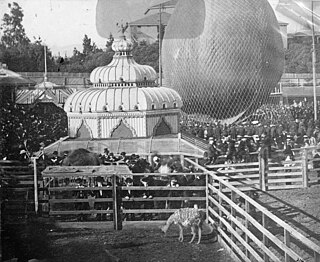
Woodward's Gardens, commonly referred to as The Gardens, was a combination amusement park, museum, art gallery, zoo, and aquarium operating from 1866 to 1891 in the Mission District of San Francisco, California. The Gardens covered two city blocks, bounded by Mission, Valencia, 13th, and 15th Streets in San Francisco. The site currently has a brick building at 1700 Mission Street, built after the 1906 San Francisco earthquake, which features a California Historical Site plaque, and the Crafty Fox Alehouse on the ground floor. The former Gardens site also features the current location of the San Francisco Armory, completed in 1914.
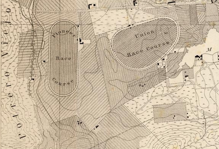
Camp Alert was an American Civil War Union Army, training camp located at the Pioneer Race Course, near San Francisco, north of Bernal Heights. Today the site location is within the city, between 24th and 25th Streets and Folsom and Mission Streets.

Union Race Course was a horse racing track opened in the 1850s in San Francisco, California located in the Mission District. There were two horse race courses in the Mission District at this time, the other being Pioneer Race Course which was located a few blocks away. At the time it was planned to be built, no streets existed in this neighborhood but later it appears to be bound by 19th St to 23rd St and Capp St to Harrison St.
George Treat (1819–1907) was an early Gold Rush-era pioneer in the Mission District, of San Francisco, a businessman, abolitionist, a member of the first Committee of Vigilance of San Francisco, and horse racing enthusiast. He was influential to the early physical development of the Mission District and its eventual shift to urbanization. Treat was responsible for the construction and management of the Pioneer Race Course, a horse racing track built in San Francisco in 1851 and in helping with the creation of the San Francisco-San Jose Railway when he sold the land.

Jackson Street is a street in San Francisco, California, running through the Pacific Heights, Nob Hill, Chinatown and Jackson Square districts of the city. It runs between Pacific Avenue and Washington Street, beginning at Arguello Boulevard to the south of the Presidio Golf Course and ending at Drumm Street, to the west of Pier 3, near Sydney G. Walton Square.
Steamboat Point a headland marking the northeastern limit of Mission Bay, on San Francisco Bay. It was named for the shipyards that built and repaired steamboats there during the 1850s to the mid 1860s.

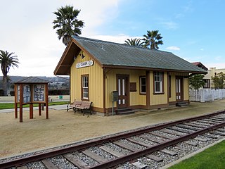
Colma station was a railway station in Colma, California. The depot was served by the Southern Pacific Railroad for most of its functional existence.


