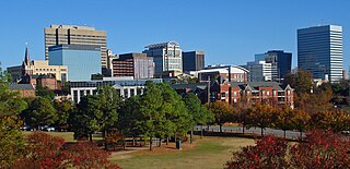
Columbia is the capital and second-largest city of the U.S. state of South Carolina, with a population estimate of 131,674 as of 2019. The city serves as the county seat of Richland County, and a portion of the city extends into neighboring Lexington County. It is the center of the Columbia metropolitan statistical area, which had a population of 767,598 as of the 2010 United States Census, growing to 832,666 by July 1, 2018, according to 2018 U.S. Census estimates. This makes it the 70th-largest metropolitan statistical area in the nation, as estimated by the United States Census Bureau as of July 1, 2018. The name Columbia is a poetic term used for the United States, derived from the name of Christopher Columbus, who explored for the Spanish Crown.

Morningside Heights is a neighborhood on the West Side of Upper Manhattan in New York City. It is bounded by Morningside Drive to the east, 125th Street to the north, 110th Street to the south, and Riverside Drive to the west. One of the three neighborhoods comprising West Harlem, Morningside Heights borders Central Harlem and Morningside Park to the east, Manhattanville to the north, the Manhattan Valley section of the Upper West Side to the south, and Riverside Park to the west. The main thoroughfare is Broadway, which runs north–south through the neighborhood.
Capitol Hill, in addition to being a metonym for the United States Congress, is the largest historic residential neighborhood in Washington, D.C., stretching easterly in front of the United States Capitol along wide avenues. It is one of the oldest residential neighborhoods in Washington, D.C., and, with roughly 35,000 people in just under 2 square miles (5 km2), it is also one of the most densely populated.

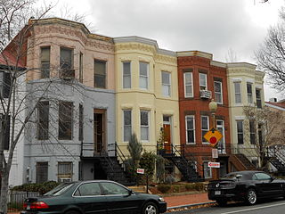
Logan Circle is a traffic circle park, neighborhood, and historic district in the Northwest quadrant of Washington, D.C. The primarily residential neighborhood includes two historic districts, properties listed on the National Register of Historic Places, and sites designated D.C. Historic Landmarks. Vermont Avenue NW, Rhode Island Avenue NW, 13th Street NW, and P Street NW meet at the circle. An equestrian statue of Major General John A. Logan stands at its center. It is the only major circle downtown that remains entirely residential.

Brewerytown is a neighborhood in the North Philadelphia section of Philadelphia, Pennsylvania, United States. An unofficial region, Brewerytown runs approximately between the Schuylkill River's eastern bank and 25th Street, bounded by Cecil B. Moore Avenue to the north and Parrish Street to the south. Brewerytown got its name because of the numerous breweries that were located along the Schuylkill during the late 19th century and early 20th century. It is now primarily a residential neighborhood, with a growing and active commercial sector along Girard Avenue.

Petworth is a residential neighborhood in the Northwest quadrant of Washington, D.C. It is bounded to the east by the Armed Forces Retirement Home and Rock Creek Cemetery, to the west by Arkansas Avenue NW, to the south by Rock Creek Church Road NW and Spring Road NW, and to the north by Kennedy Street NW.
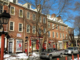
Society Hill is a historic neighborhood in Center City Philadelphia, Pennsylvania with a population of 6,215 as of the 2010 United States Census. Settled in the early 1680s, Society Hill is one of the oldest residential neighborhoods in Philadelphia. After urban decay developed between the late 19th and early 20th centuries, an urban renewal program began in the 1950s, restoring the area and its many historic buildings. Society Hill has since become one of the most expensive neighborhoods with the highest average income and second highest real estate values in Philadelphia. Society Hill's historic colonial architecture, along with intelligent planning and restoration efforts, led the American Planning Association to designate it, in 2008, as one of the great American neighborhoods and a good example of sustainable urban living.
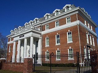
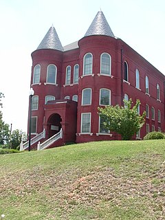
Allen University is a private historically black university in Columbia, South Carolina. It has more than 600 students and still serves a predominantly Black constituency. The campus is listed on the National Register of Historic Places as Allen University Historic District.

Boulevard Oaks is a neighborhood in Houston, Texas, United States, containing 21 subdivisions north of Rice University and south of U.S. Highway 59. Developed primarily during the 1920s and 1930s, Boulevard Oaks contains two National Register historic districts, Broadacres and Boulevard Oaks. The Boulevard Oaks Civic Association (BOCA) is the common civic association for all 21 subdivisions.

The Old Campus District, University of South Carolina, is a historic district centered on The Horseshoe on the main campus of the University of South Carolina in Columbia, South Carolina. On June 5, 1970, it was listed in the National Register of Historic Places. On April 19, 1996 MTV Unplugged filmed Hootie & the Blowfish's concert on The Horseshoe before the release of their second album Fairweather Johnson.

Elmwood Park is a residential neighborhood and historic district in what is now the center of Columbia, South Carolina. Founded in the early 1900s, it was added to the National Register of Historic Places as Elmwood Park Historic District on May 3, 1991.
The East Raleigh–South Park Historic District is the largest African-American neighborhood in Raleigh, North Carolina. The district, located south and east of downtown Raleigh, covers approximately 30 blocks and contains portions of the Smith–Haywood and St. Petersburg neighborhoods. Most homes in these neighborhoods were built between 1900 and 1940, with one-fifth dating back to the 19th century. Historic buildings in the district include Estey Hall and Leonard Hall, both located on the campus of Shaw University. The district was listed on the National Register of Historic Places in October 1990.
William Augustus Edwards, also known as William A. Edwards was an Atlanta-based American architect renowned for the educational buildings, courthouses and other public and private buildings that he designed in Florida, Georgia and his native South Carolina. More than 25 of his works have been listed on the National Register of Historic Places.
Winnona Park is a historic area in the southeast corner of the Atlanta, Georgia neighborhood of Decatur. It is listed as a historic district on the National Register of Historic Places, but it is not one of the City of Decatur's locally designated historic districts.

Historic Oakwood is a neighborhood in downtown Raleigh, North Carolina, United States, on the National Register of Historic Places, and known for its Historic Oakwood Cemetery, its many Victorian houses and its location close to the Mordecai Plantation Manor. Located near the State Capitol and St. Augustine's Chapel, during the 19th century Historic Oakwood was home to prominent members of Raleigh's society. It is North Carolina's largest, intact 19th Century residential neighborhood and Raleigh's earliest white middle-class suburb. Unlike later suburbs, it developed lot-by-lot over time, instead of by platted sections. Its Victorian-era architectural styles include Second Empire, Queen Anne, and Italianate. Later infill brought the bungalow, the American Foursquare, American Craftsman style, and the Minimal Traditional house to the area.

There are 69 properties listed on the National Register of Historic Places in Albany, New York, United States. Six are additionally designated as National Historic Landmarks (NHLs), the most of any city in the state after New York City. Another 14 are historic districts, for which 20 of the listings are also contributing properties. Two properties, both buildings, that had been listed in the past but have since been demolished have been delisted; one building that is also no longer extant remains listed.

The Greyhound Bus Depot is a former Greyhound Lines intercity bus station in Columbia, South Carolina. It is at 1200 Blanding Street in downtown Columbia. The depot was named to the National Register of Historic Places on December 28, 1989. After the bus terminal was closed, the building became a bank. Currently, it is a physician's office.

German Evangelical Lutheran Church of St. Mark is a historic church and synagogue building at 323 East 6th Street between First and Second Avenues in the East Village neighborhood of Manhattan, New York City. The Renaissance Revival style church was built in 1847 by the Evangelical Lutheran Church of St. Matthew which first rented it to St. Mark's and subsequently sold it to them in 1857. Much of the church membership was killed in the 1904 General Slocum disaster, and the congregation never recovered.
Charles Coker Wilson was an American architect based in Columbia, South Carolina. Wilson was born in Hartsville, South Carolina, and graduated from South Carolina College with an engineering degree in 1886, continuing on to receive his master's degree in 1888. He briefly studied architecture in the Atelier Duray at the École des Beaux-Arts in Paris. Much of his work contained Beaux-Arts elements. Architects who worked for Wilson include Joseph F. Leitner, during 1901–1905, who became a noted architect in Wilmington, North Carolina; and Henry Ten Eyck Wendell, during 1905–1906.

The Alta Vista–Camp Fornance–Newman Park Historic District, is a predominantly residential historic district in northwestern Columbia, South Carolina. It encompasses much of the neighborhood of Earlewood, and is formed out of three separate subdivisions that were developed as streetcar suburbs in the early 20th century. The district is about 225 acres (91 ha) in size, and has more than 550 residences, many in architectural styles popular in the first half of the 20th century. It is roughly bounded on the east and south by the tracks of the Seaboard Air Line, the north by Earlewood Park and Lakewood Avenue, and the northwest by Darlington Avenue.


