Related Research Articles

Lake of the Woods County is a county in the northwestern part of the U.S. state of Minnesota. As of the 2020 census, the population was 3,763, making it the second-least populous county in Minnesota. Its county seat is Baudette.

Northern Manitoba is a geographic and cultural region of the Canadian province of Manitoba. Originally encompassing a small square around the Red River Colony, the province was extended north to the 60th parallel in 1912. The region's specific boundaries vary, as "northern" communities are considered to share certain social and geographic characteristics, regardless of latitude.

Unorganized North Algoma District is an unorganized area in northeastern Ontario, Canada, comprising all areas in Algoma District, north of the Sault Ste. Marie to Elliot Lake corridor, which are not part of an incorporated municipality or a First Nation. It covers 44,077.03 km2 (17,018.24 sq mi) of land, and had a population of 6050 in 2021. Many of these communities were/are stations on the Algoma Central Railway or were logging/mining towns.

Parkland is an informal geographic region of the Canadian province of Manitoba, located between Lakes Manitoba and Winnipegosis on the east and the Manitoba–Saskatchewan border on the west.

Eastern Manitoba, or the Eastman Region, is an informal geographic region of the Canadian province of Manitoba. It is bounded on the north by the Winnipeg River and Lake Winnipeg, on the east by the Manitoba-Ontario border, on the south by the Canada–US border, and on the west by the Red River. With a population of 128,855 as of the 2021 Canadian census, the Eastman Region is the second most populous region outside of the Winnipeg Metropolitan Region.

St. Theresa Point First Nation is a First Nations community in northern Manitoba. It has 3 reserves in total, the largest and most populated of which is St. Theresa Point, which is bordered by the unorganized portion of Division No. 22, Manitoba, and by the Wasagamack First Nation.

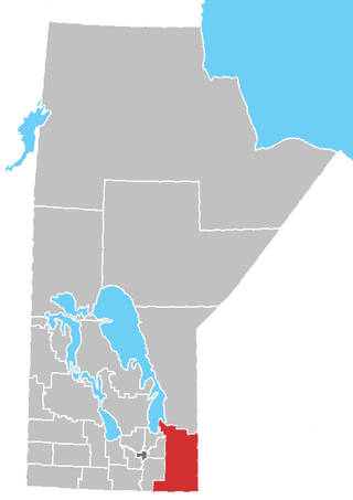
Division No. 19, also informally known as North East Manitoba, is a census division within the Province of Manitoba, Canada. Unlike in some other provinces, census divisions do not reflect the organization of local government in Manitoba. These areas exist solely for the purposes of statistical analysis and presentation; they have no government of their own.
Division No. 21, also informally known as Flin Flon-Northwest, is a census division within the Province of Manitoba, Canada. Unlike in some other provinces, census divisions do not reflect the organization of local government in Manitoba. These areas exist solely for the purposes of statistical analysis and presentation; they have no government of their own.

Waldheim is a town of 1,035 residents in the Rural Municipality of Laird No. 404, in the Canadian province of Saskatchewan, 57 kilometres (35 mi) north of Saskatoon. Waldheim is located on Highway 312 in central Saskatchewan, the "Heart of the Old North-Wes". Fort Carlton, Batoche, Battle of Fish Creek, and Seager Wheeler's Maple Grove Farm are all near Waldheim.
Division No. 1 is a census division located within the Eastman Region of the Canadian province of Manitoba. Unlike in some other provinces, census divisions do not reflect the organization of local government in Manitoba. These areas exist solely for the purposes of statistical analysis and presentation; they have no government of their own.
Census Division No. 23 is a census division located within the Northern Region of the Province of Manitoba, Canada. Unlike in some other provinces, census divisions do not reflect the organization of local government in Manitoba. These areas exist solely for the purposes of statistical analysis and presentation; they have no government of their own.
Census Division No. 20 is a census division located within the Parkland Region of the province of Manitoba. Unlike in some other provinces, census divisions do not reflect the organization of local government in Manitoba. These areas exist solely for the purposes of statistical analysis and presentation; they have no government of their own.
Census Division No. 18 is a census division located within the Interlake Region of the province of Manitoba, Canada. Unlike in some other provinces, census divisions do not reflect the organization of local government in Manitoba. These areas exist solely for the purposes of statistical analysis and presentation; they have no government of their own.
Census Division No. 17 (Dauphin) is a census division located within the Parklands Region of the province of Manitoba, Canada. Unlike in some other provinces, census divisions do not reflect the organization of local government in Manitoba. These areas exist solely for the purposes of statistical analysis and presentation; they have no government of their own.
Division No. 1, Unorganized, or Whiteshell Unorganized, is a Statistics Canada census subdivision of its Division No. 1, Manitoba that consists of a part of the division that is not organized into either incorporated municipalities or Indian reserves. Unlike in some other provinces, census divisions do not reflect the organization of local government in Manitoba.
Manitoba's Swan-Pelican Provincial Forest lies just west of Lake Winnipegosis, and is named for the two smaller lakes in the area, Swan Lake and Pelican Lake. The forest has an area of 3,705 km2, and is the second-largest provincial forest in Manitoba. Most of the forest is located within the unorganized portion of Census Division No. 19, but its southernmost reaches extend into the Rural Municipality of Mountain (South). A fairly newly established forest, it was not officially recognized as a provincial forest until 1987.
Division No. 21, Unorganized, or Flin Flon–Snow Lake–Kelsey Unorganized, is an unorganized area in northwestern Manitoba. It consists of all of Division No. 21 excluding municipalities and reserves. Unlike in some other provinces, census divisions do not reflect the organization of local government in Manitoba. These areas exist solely for the purposes of statistical analysis and presentation; they have no government of their own.
Little George Island Ecological Reserve is an ecological reserve located on an island in the Lake Winnipeg, Manitoba, Canada. It was established in 2004 under the Manitoba Ecological Reserves Act. It is .15 square kilometres (0.058 sq mi) in size.
References
- ↑ mob-rule. "County lines over OpenStreetMap data" . Retrieved 21 December 2021.
- ↑ "Census profile, Division No. 19, Unorganized". Statistics Canada . Retrieved 9 October 2017.
Places adjacent to Unorganized Division No. 19, Manitoba | |
|---|---|
Division No. 19, Manitoba (North East Manitoba) | ||
|---|---|---|
| First Nations |  | |
| Indian reserves |
| |
| Unorganized areas | ||
| Unincorporated communities | ||
52°19′N97°13′W / 52.31°N 97.21°W
| | This Manitoba-related article is a stub. You can help Wikipedia by expanding it. |