
Gillam is a town on the Nelson River in northern Manitoba, Canada. It is situated between Thompson and Churchill on the Hudson Bay Railway line.
Brochet is an unincorporated community located in Northern Manitoba on the northern shore of Reindeer Lake near the Saskatchewan border; it is designated as a northern community.
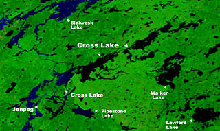
Cross Lake is a community in the Northern Region of the Canadian province of Manitoba, situated on the shores of the Nelson River where the river enters the namesake Cross Lake. An all-weather road, PR 374, connects the communities to PR 373 via the Kichi Sipi Bridge.
Duck Bay is a community located in the Canadian province of Manitoba, along the western shores of Lake Winnipegosis.

Easterville is an unincorporated community, designated as a northern community, in the Canadian province of Manitoba.

Riverton is an unincorporated urban community in the Municipality of Bifrost-Riverton within the Canadian province of Manitoba.

Moose Lake is a small community in Manitoba, Canada. It is located on the eastern edge of the Saskatchewan River Delta on the western shore of South Moose Lake about 74 km southeast of The Pas. Adjacent to the non-treaty community is a First Nations reserve, home to the Mosakahiken Cree Nation.
Ashmont, Alberta is a hamlet in northern Alberta, Canada within the County of St. Paul No. 19. It is located near the intersection of Highway 28 and Highway 36, approximately 33 kilometres (21 mi) northwest of the Town of St. Paul. It has an elevation is 2,073 feet (632 m).
Powerview-Pine Falls is a town in the Canadian province of Manitoba, with a population of 1,314 at the 2011 census, up 1.54% from 1,294 at the 2006 census and down 7.57% from 1,400 during the 2001 census.

Bissett is a community situated on Rice Lake in the southeastern region of Manitoba, Canada, classified as a northern community and designated place. Located two and a half hours northeast of Winnipeg on Provincial Road 304, Bissett is an entry point to Nopiming Provincial Park.
Waterhen 45 is a First Nations reserve in the Canadian province of Manitoba.
Chipewyan Lake is an unincorporated community in northern Alberta within the Municipal District of Opportunity No. 17. It is located on the southern shore of Chipewyan Lake approximately 110 kilometres (68 mi) north of Wabasca and 128 kilometres (80 mi) west of Fort McMurray. The community is not accessible by Alberta's provincial highway system. It is however accessible by using the Laricina Energy/Shell Canada S-4 access road.
Cadotte Lake is an unincorporated community in northern Alberta, Canada within Northern Sunrise County. It is located on the northern shore of the homonymous lake, along Highway 986, 79 km (49 mi) east of Peace River and 68 km (42 mi) west of the Bicentennial Highway.
Calling Lake is a hamlet in northern Alberta, Canada within the Municipal District of Opportunity No. 17. It is located on Highway 813 along the eastern shore of Calling Lake, immediately north of Calling Lake Provincial Park. It is approximately 59 km (37 mi) north of Athabasca and 113 km (70 mi) south of Wabasca and has an elevation of 595 m (1,952 ft).
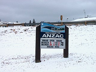
Anzac is a hamlet in northern Alberta, Canada within the Regional Municipality (RM) of Wood Buffalo. It is located on Highway 881 along the east shore of Gregoire Lake, approximately 36 kilometres (22 mi) southeast of Fort McMurray.
North Cooking Lake is a hamlet in Alberta, Canada within Strathcona County. It is located on Highway 630 and on the northeast shore of Cooking Lake, approximately 24 kilometres (15 mi) southeast of Sherwood Park. It is 4 kilometres (2.5 mi) south of the Waskehegan Staging Area entrance to Cooking Lake-Blackfoot Grazing, Wildlife Provincial Recreation Area.

Antler Lake is a hamlet in Alberta, Canada within Strathcona County. It is located on the shores of Antler Lake on Range Road 211 and 211A just north of Wye Road, approximately 18 km (11 mi) east of Sherwood Park and 25 km (16 mi) northwest of Tofield.
Dawson Bay is a community in the Canadian province of Manitoba.
Meadow Portage is a community in the Canadian province of Manitoba.
Dallas/Red Rose is a designated northern community in the Canadian province of Manitoba, consisting of the adjacent communities of Dallas and Red Rose. The communities had a total population of 159 as of the 2016 census, up from 45 in the 2006 census.
