Upper Appomattox Canal Navigation System

Last updated
Upper Appomattox Canal Navigation System
Appomattox Canal Dam.jpg
The Abutment Dam, the Appomattox Canal Dam, brought water to the Upper Appomattox Canal.
Specifications
Maximum boat beam 5 ft 0 in (1.52 m)
Locks17 Locks
(Staircase fashion around the Fall Line and along the river)
StatusNo longer in use since 1890
Navigation authority Virginia General Assembly
History
Original ownerUpper Appomattox Canal company
Principal engineerJohn Couty (1830)
Date of act1796
Construction began1809
Date completed1816
Date closed1890
Geography
Start point Farmville, Virginia
End point Petersburg, Virginia
Branch(es) Appomattox River
Branch of James River

The Upper Appomattox Canal Navigation system allowed farmers who took their wheat and corn to mills on the Appomattox River, as far way as Farmville, Virginia, to ship the flour all the way to Petersburg from 1745 to 1891. The system included a navigation, modifications on the Appomattox River, a Canal around the falls Petersburg, and a turning basin in Petersburg to turn their narrow long boats around, unload the farm products from upstream and load up with manufactured goods from Petersburg. In Petersburg, workers could put goods on ships bound for the Chesapeake Bay and load goods from far away for Farmville and plantations upstream. Canal boats would return up river with manufactured goods. People who could afford it, rode in boats on the canal as the fastest and most comfortable ride. The river was used for transportation and shipping goods for over 100 years.

Contents

History

The River was modified for transportation around 1745 and further modified over its years of use. Much of the canal system was built by slaves. Freed Blacks of Israel Hill worked as Boatman. [1] The Canal took damage in the Civil War and was used until faster rail transportation was available.

Cleared 1745

The Appomattox River was cleared for bateau by 1745. [2] These boats were the same dimensions as the James River bateau, sixty feet long, six feet wide and two feet deep. It was also designed to carry the largest load through the smallest parts of the river system. Unlike the James River bateau, the Appomattox trips went up and down river so they were not designed to be sold as lumber at the end of the voyage. [3]

The Virginia General Assembly passed laws to protect navigation on the James River and Appomattox. By statute, a dam could not be built unless it had locks for boat passage. [4]

Appomattox River Canal Navigation System 1814 Map cropped from a map of Eastern Virginia by Samuel Lewis. Appomattox River Canal Navigation System 1814 Map.jpg
Appomattox River Canal Navigation System 1814 Map cropped from a map of Eastern Virginia by Samuel Lewis.

Upper Appomattox Company 1795

Upper Appomattox Canal company
Public
Founded1795
Defunct1890
Area served
Farmville, Virginia to Petersburg, Virginia and Chesterfield, Amelia, Buckingham and Cumberland between.
Key people
In 1799
  • John Archer, President
  • John Royal, Officer
. In 1863
  • W.E. Hinton, President
  • N. M. Osborne , Officer
  • Major John Robinson Officer
.

The Virginia General Assembly incorporated the Upper Appomattox Company in 1795. The state had bought 125 shares by 1801 to support the growth of transportation. In 1807, the company is allowed to sell bonds for one fourth of the expense of building the canal. A 335 foot long dam in the Appomattox diverted water to the canal. The canal was built entirely by enslaved Africans owned by the company. [4]

Canal built in 1816

The Appomattox Canal, built in 1816, connected 5.5 miles from the head of the falls at the Fall Line on the Appomattox River to the Turning basin in Petersburg, Virginia. Built for $60,000, the canal was big enough to carry the bateau, six feet wide and three feet deep. With another $10,000 it could carry all river traffic. [5] Slaves enhanced the Appomattox River from Farmville over 100 miles to Petersburg with numerous wing dams to keep the flow high. [3] The river also had four stone staircase locks. Four watermills along the river had locks in their dams. Two of these watermills had stone locks. [2]

The Canal around the falls had a navigable aqueduct made with Stone Arches and stone culverts to take boats over the Rohoic Creek confluence on the way to the canal basin. [2] A short distance from the Basin, connected a by carriage route, were deep water ports that allowed for transport of to goods to and from the Chesapeake Bay and beyond. [3]

Israel on the Appomattox

One third of Bateau were owned by Free people of color. Bateau owned by White People employed white boatmen as well as freemen and slaves. One fourth of all cargo was transported from Farmville in bateau on the Appomattox River. [4] Slaves on one plantation, including Sam White, inherited land from a repentant southerner, Richard Randolph, in 1810. He had freed them upon his death in 1796. They formed a town on the land and farmed, built buildings on the land and operated many of the boats on the Appomattox, transporting goods for a fee. They were still living there as freemen up to the time of the Emancipation Proclamation. [6]

Rebuilt in 1830

Upper Appomattox Canal begins upstream as a contour canal split out of granite and dug out of soil and clay. Upper Appomattox Canal Blasted Out of Rock.jpg
Upper Appomattox Canal begins upstream as a contour canal split out of granite and dug out of soil and clay.
The Granite Arches of the Navigable aqueduct over Rohoic Creek still remain. Stone Arches of Rohoic Creek Navigable Aqueduct.jpg
The Granite Arches of the Navigable aqueduct over Rohoic Creek still remain.

In 1829 the Virginia General Assembly hired a public engineer to determine the possibility and cost of connecting the upper Appomattox River to the Roanoke River at the Mouth of the Staunton from the Appomattox past Farmville by canal or rail. [7] However, that canal connection was never built.

The Upper Appomattox Canal, in Petersburg, was rebuilt by John Couty as a lock and dam system with a total of 17 locks and 8 miles. It was still designed for bateau. [2] Tolls were paid by shippers to support the cost of maintaining the locks and dams. [3] In fiscal year, 1831, boatmen shipped around 20,000 barrels of flour and 20,000 barrels of wheat; 5,000 hogsheads of tobacco leaf, and some tobacco stems; half a million pounds of manufactured goods, barrel staves, cotton, corn, salt, lime and iron. [4] By 1836, Petersburg was connected to docks at City Point by the City Point Railroad rather than carriage. Petersburg was also connected to the north by rail on the Richmond and Petersburg Railroad and the South on the Petersburg Railroad in the 1830s.

Eppington

Epps Falls, at the Eppington Plantation, were deemed dangerous for passing boats by the Virginia General Assembly. The General Assembly gave Archibald Thweatt, owner of Eppington, compensation from any damages but allowed the Upper Appomattox Canal company to build a dam and locks around the falls in 1819. Archibald Thweatt and his heirs were also given leave to build a grist mill on the dam. [8]

In the 1830s Eppington plantation at Epps Falls on the Appomattox River had 100 slaves, a warehouse and a dock. Neighboring farmers could ship farm produce from the docks. [9] There were large loading facilities. When coal was first mined at the Clover Hill Pits, in 1837, it was taken by mule, later by rail, to the docks at Epps Falls. A boat that could carry seven tons of coal, made a four-day round trip to Petersburg for two dollars and thirty eight cents. This would soon be replaced by transport on the Clover Hill Railroad. [10]

Water power below the basin in 1850

Water flowing below the Basin down into the Appomattox powered mills and factories. [3] The mills produced cotton, wool, hemp flax and flour. The flour was exported as far way as Brazil. [5]

Civil War damage 1865

Canal Aqueduct - Petersburg 1865. Wooden Aqueduct to replace the damaged stone aqueduct. Wooden Replacement of Appomattox Canal Aqueduct - Petersburg 1865.jpg
Canal Aqueduct - Petersburg 1865. Wooden Aqueduct to replace the damaged stone aqueduct.

During the Siege of Petersburg, in the American Civil War, there were not enough soldiers to block Union advancement in all places. The Confederate States Army dammed Rohoic Creek with a large dam that would be difficult to cross. The dam failed and washed away the 1826 navigable aqueduct and the Southside Railroad.

Upper Appomattox Canal company in Reconstruction 1872-1877

In 1872, W.E. Hinton, Jr, as president of the Upper Appomattox Canal Company, asked shareholders to agree to correct mismanagement, since there had not been a shareholder meeting since 1866. This mismanagement included paying out dividends before making repairs to the canal. Dividends were paid out ignoring 70 shares of stock, out of roughly 1100, which allowed others to get a higher dividend. Also, one shareholder who tore down canal property tried to sell off the bricks. An unauthorized grist mill was built using the canal water. One officer who let the city of Petersburg take cobbles from canal property to build a road across the canal property to the officers own mill. This made other rentals of water useless, since a road lay where their mills would be. The mill owner would have had to buy water rights to the water power in a competitive bid, but having built a road where their competition would build mills, they paid a much lower price for the water. Hinton suggested that $600 was a reasonable rent to charge the mill owner, because there should have been a competitive bid allowed. [11]

Senator Hinton, was elected as an officer in 1872 and got the right to sell bonds. In 1876, Bonds are given to Hinton as $4000 salary; sold to Captain N. M. Osborne and Major John Robinson of Baltimore and given to the State of Virginia, the Bank of Petersburg, and private banker N.M. Osborne and E.S. Stith as collateral. The money from the bonds, was used to rebuild the Navigable Aqueduct on Old Town Creek, now called Rohoic Creek, and rebuild a lock keeper's home, buildings, several locks and dams for mills. [12] [13] The next year the General Assembly gave the company the right to sell bonds to buy company stock back from the state. The General Assembly also let the company have an additional 10 years to buy back the stock. [14]

After Reconstruction 1877

Detail Beers Map 1879 - Upper Appomattox Canal Turning Basin Detail Beers Map 1879 - Upper Appomattox Canal Turning Basin.jpg
Detail Beers Map 1879 - Upper Appomattox Canal Turning Basin

After the Emancipation Proclamation and after the end of Reconstruction Era on April 2, 1877,the Virginia General Assembly approved the Virginia governor providing twenty to twenty five prisoners under convict lease to the Upper Appomattox canal company. [15] Convict Lease was described by the writer Douglas A. Blackmon as "a system in which armies of free men, guilty of no crimes and entitled by law to freedom, were compelled to labor without compensation, were repeatedly bought and sold, and were forced to do the bidding of white masters through ... physical coercion." [16]

Farmville and Powhatan Railroad connects to James River 1891

The Canal was used in part until the 1890s. [5] In 1890, the Canal would have had competition with the Farmville and Powhatan Railroad which competed with the Southside Railroad. The Farmville and Powhatan was connected all the way to Bermuda Hundred on the James River and Chester, Virginia, just north of Petersburg, in 1891. The railroad was narrow gauge but could provide transportation for goods and people over a similar route as the canal in just four hours. The railroads were pricing lower due to competition and made the trip in hours rather than days. [17]

What remains of the canal today

The wing dams can still be seen in some places. [2] The first few miles of the canal from the abutment dam, a contour canal, can be walked in Appomattox River Park in Petersburg. Remains of the navigable aqueduct and other stone work remain on the Appomattox River & Heritage Trail in Petersburg, Virginia. The straight part of the canal to the turning basin follows Upper Appomattox Street and was part of the Seaboard Air Line Railroad for many years. The location of the turning basin is at Dunlop Street, High Street, South Street and Commerce. The water used to flow down Canal street back to the Appomattox River. [18] Eppington is still in Chesterfield and is open to the public a few days a year. [19] Israel Hill has a historical marker in Farmville, Virginia. [1]

Related Research Articles

Canal Man-made channel for water

Canals are waterways channels, or artificial waterways, for water conveyance, or to service water transport vehicles. They may also help with irrigation. It can be thought of as an artificial version of a river. Canals carry free surface flow under atmospheric pressure.

Fluvanna County, Virginia U.S. county in Virginia

Fluvanna County is a county located in the Piedmont region of the Commonwealth of Virginia. As of the 2010 census, the population was 25,691. Its county seat is Palmyra.

Chesterfield County, Virginia County in Virginia

Chesterfield County is located just south of Richmond in the Commonwealth of Virginia. The county's borders are primarily defined by the James River to the north and the Appomattox River to the south. Its county seat is Chesterfield Court House.

Farmville, Virginia Town in Virginia, United States

Farmville is a town in Prince Edward and Cumberland counties in the U.S. state of Virginia. The population was 8,216 at the 2010 census. It is the county seat of Prince Edward County.

Chesapeake and Ohio Canal Canal in Washington, D.C. and Maryland, United States

The Chesapeake and Ohio Canal, abbreviated as the C&O Canal and occasionally called the "Grand Old Ditch," operated from 1831 until 1924 along the Potomac River from Washington, D.C., to Cumberland, Maryland. The canal's principal cargo was coal from the Allegheny Mountains.

James River River in Virginia, United States

The James River is a river in the U.S. state of Virginia that begins in the Appalachian Mountains and flows 348 miles (560 km) to Chesapeake Bay. The river length extends to 444 miles (715 km) if one includes the Jackson River, the longer of its two source tributaries. It is the longest river in Virginia. Jamestown and Williamsburg, Virginia’s first colonial capitals, and Richmond, Virginia's current capital, lie on the James River.

Union Canal (Scotland)

The Union Canal, full name the Edinburgh and Glasgow Union Canal, is a canal in Scotland, running from Falkirk to Edinburgh, constructed to bring minerals, especially coal, to the capital. It was opened in 1822 and was initially successful, but the construction of railways, particularly the Edinburgh and Glasgow Railway, which opened in 1842, diminished its value as a transport medium. It fell into slow commercial decline and was closed to commercial traffic in 1933. It was officially closed in 1965. The canal is listed as three individual scheduled monuments by Historic Scotland according to the three former counties, Midlothian, West Lothian and Stirlingshire, through which it flows.

Appomattox River

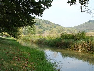
The Appomattox River is a tributary of the James River, approximately 157 miles (253 km) long, in central and eastern Virginia in the United States, named for the Appomattocs Indian tribe who lived along its lower banks in the 17th century. It drains a cotton and tobacco-growing region of the Piedmont and coastal plain southwest of Richmond.

Chesapeake and Ohio Canal National Historical Park National Historical Park located in the District of Columbia and the states of Maryland and West Virginia

The Chesapeake and Ohio Canal National Historical Park is located in the District of Columbia and the state of Maryland. The park was established in 1961 as a National Monument by President Dwight D. Eisenhower to preserve the neglected remains of the Chesapeake and Ohio Canal and many of its original structures. The canal and towpath trail extends along the Potomac River from Georgetown, Washington, D.C., to Cumberland, Maryland, a distance of 184.5 miles (296.9 km). In 2013, the path was designated as the first section of U.S. Bicycle Route 50.

Middlesex Canal barge canal in eastern Massachusetts, US

The Middlesex Canal was a 27-mile (44-kilometer) barge canal connecting the Merrimack River with the port of Boston. When operational it was 30 feet wide, and 3 feet deep, with 20 locks, each 80 feet long and between 10 and 11 feet wide. It also had eight aqueducts.

James River and Kanawha Canal United States historic place

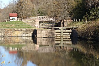
The James River and Kanawha Canal was a partially built canal in Virginia intended to facilitate shipments of passengers and freight by water between the western counties of Virginia and the coast. Ultimately its towpath became the roadbed for a rail line following the same course.

Main Line of Public Works United States historic place

The Main Line of Public Works was a package of legislation supporting a vision passed in 1826—a collection of various long proposed canal and road projects that became a canal system and later added railroads designed to cross the breadth of Pennsylvania with the visionary goal of providing the best commercial means of transportation between Philadelphia and Pittsburgh. Built between 1826 and 1834 by the Commonwealth of Pennsylvania, it established the Pennsylvania Canal System, the Allegheny Portage Railroad, and the Pennsylvania Canal System administrated under a new Commission.

Schuylkill Canal

The Schuylkill Canal, or Schuylkill Navigation, was a system of interconnected canals and slack-water pools along the Schuylkill River in the U.S. state of Pennsylvania, built as a commercial waterway in the early 19th-century. Chartered in 1815, the navigation opened in 1825 to provide transportation and water power. At the time, the river was the least expensive and most efficient method of transporting bulk cargo, and the eastern seaboard cities of the U.S. were experiencing an energy crisis due to deforestation. It fostered the mining of anthracite coal as the major source of industry between Pottsville and eastern markets. Along the tow-paths, mules pulled barges of coal from Port Carbon through the water gaps to Pottsville; locally to the port and markets of Philadelphia; and some then by ship or through additional New Jersey waterways, to New York City markets.

City Point Railroad

In 1836, the Virginia House of Delegates approved a charter for the City Point Railroad. City Point, Virginia was just ten years old. The Lower Appomattox Company ran boats of cargo from Petersburg, Virginia to the large port at City Point. The company knew that the port needed a rail road to be competitive in the 1830s even though this would only be the second rail road in Virginia. Large ships that were too large for Port Walthall or Petersburg had to load and unload at City Point. Goods for export arrived in Petersburg from farms and plantations by way of the Upper Appomattox Canal Navigation System. The Richmond and Petersburg Railroad bringing coal and goods to port was also chartered in 1836. Coal arriving by boat from the Clover Hill Pits in 1837 and goods would soon be taken on the Clover Hill Railroad to connect with the Richmond and Petersburg Railroad to export from the area ports.

Whitewater Canal United States historic place

The Whitewater Canal, which was built between 1836 and 1847, spanned a distance of seventy-six miles and stretched from Lawrenceburg, Indiana on the Ohio River to Hagerstown, Indiana.

Lehigh Canal United States historic place

The Lehigh Canal or the Lehigh Navigation Canal is a navigable canal, beginning at the mouth of Nesquehoning Creek on the Lehigh River in Eastern Pennsylvania. It was built in two sections over a span of twenty years, beginning in 1818. The lower section spanned the distance between Easton, Pennsylvania and the town of Mauch Chunk, present-day Jim Thorpe, Pennsylvania. In Easton the canal met the Delaware and Morris Canals, with which goods could be brought further up the east coast. At its height, the Lehigh Canal was 72 miles (116 km) long.

Eppington United States historic place

Eppington is a historic plantation house located near Winterpock, Chesterfield County, Virginia. It was built about 1768, and consists of a three-bay, 2 1/2-story, central block with hipped roof, dormers, modillion cornice, and flanking one-story wings in the Georgian style. It has a later two-story rear ell. It features two tall exterior end chimneys which rise from the roof of the wings. It was listed on the National Register of Historic Places in 1969.

Tidewater and Western Railroad

The Farmville and Powhatan Railroad went bankrupt in 1905 and became the Tidewater and Western Railroad. The line survived until 1917 when it was pulled up and sent to France for the World War I effort. The Tidewater and Western Railroad carried freight and passengers along a route from Farmville, Virginia to Bermuda Hundred. The Tidewater and Western Railroad continued to have Western Union Telegraphs run along the rails. These connected to telegraphs on the Atlantic Coast Line along the East Coast of the US and to Europe.

Richard N. Venable

Richard N. Venable (1756–1838) was a nineteenth-century American politician from Virginia.

Bellows Falls Canal

Bellows Falls Canal is a canal constructed to allow boat traffic to bypass Great Falls on the Connecticut River in Bellows Falls, Vermont. It was constructed by the Bellows Falls Canal Company and was one of the first canals in the United States. It was used for transport, to power mills, and later for hydroelectric power. The Bellows Falls Downtown Historic District includes the canal.

References

  1. 1 2 Jones, Randy (2009-04-15). "Ten New State Historical Highway Markers Approved" (PDF). Department of Historic Resources. Department of Historic Resources. Archived from the original (PDF) on 2015-09-23. Retrieved 2015-08-25.
  2. 1 2 3 4 5 Trout III, W (1973-06-13). "The Upper Appomattox Navigation, Virginia" (PDF). American Canals. American Canal Society. Retrieved 2017-01-18.
  3. 1 2 3 4 5 Melvin Patrick Ely (1 December 2010). Israel on the Appomattox: A Southern Experiment in Black Freedom from the 1790s Through the Civil War. Knopf Doubleday Publishing Group. pp. 151–. ISBN   978-0-307-77342-5.
  4. 1 2 3 4 Annual Report of the Board of Public Works to the General Assembly of Virginia: With the Accompanying Documents. Thomas Ritchie. 1830. pp. 145–156.
  5. 1 2 3 Diane Barnes (1 June 2008). Artisan Workers in the Upper South: Petersburg, Virginia, 1820-1865. LSU Press. pp. 22–26. ISBN   978-0-8071-3419-1.
  6. Ely, Melvin (August 5, 2007). "'Israel on the Appomattox'". New York Times. New York, New York. Retrieved 2017-01-25.
  7. Virginia. Board of Public Works (1829). Annual Report of the Board of Public Works to the General Assembly of Virginia, with the Accompanying Documents. pp. 589–590.
  8. Acts Passed at a General Assembly of the Commonwealth of Virginia. 1819. pp. 195–196.
  9. Stith, M.D. (August 23, 1989). "Eppington: Crown Jewel of Chesterfield County" (PDF). Eppington Foundation. Eppington Foundation. Retrieved 2017-01-25.
  10. Gerald P. Wilkes (1988). MINING HISTORY OF THE RICHMOND COALFIELD OF VIRGINIA (PDF) (Report). VIRGINIA DIVISION OF MINERAL RESOURCES PUBLICATION 85. p. 10,29–30. Retrieved 2017-01-25.
  11. Hinton, William (1872-11-11). "To the stockholders of the Upper Appomattox Company". Duke University Libraries. Duke University Libraries. Retrieved 2017-01-23.
  12. Journal of the Senate of Virginia. Commonwealth of Virginia. 1878. pp. 35–52.
  13. Journal. 1878. pp. 32–45.
  14. Acts of the General Assembly of the Commonwealth of Virginia. 1877. pp. 218–219.
  15. Virginia (1877). Acts Passed at a General Assembly of the Commonwealth of Virginia. p. 304.
  16. Blackmon, Douglas A. Slavery by Another Name: The Re-Enslavement of Black Americans from the Civil War to World War II, (2008) ISBN   978-0-385-50625-0, p. 4
  17. Virginia. Railroad Commissioner (1893). Annual Report of the Railroad Commissioner of the State of Virginia. R.F. Walker, Superintendent Pub. Print. pp. xx–xxx.
  18. Jost, Scott (March 12, 2010). "More Images from the Indian Town Creek Aqueduct Site". Chesapeake Bay Watershed Confluences. Bridgewater College. Retrieved 2017-01-29.
  19. "Eppington Plantation". Eppington Foundation. Eppington Foundation. 2014. Retrieved 2017-01-29.