Valpovo

Last updated • 3 min readFrom Wikipedia, The Free Encyclopedia
Valpovo
Grad Valpovo
Town of Valpovo
Valpovo Korzo.jpg
Dvorac Prandau-Normann dvorac iz zraka.jpg
Prandauovo kazaliste.jpg
Land Art Tour in Valpovo.jpg
M101 howitzer in Valpovo, Croatia.jpg
Karasica-Valpovo-Sokci-u-camcu.jpg
Perivoj u Valpovu.jpg
Valma-Valpovo.JPG
Kulturni centar-Valpovo.JPG
Valpovo
Coat of arms of Valpovo.svg
Osijek-Baranja County OpenStreetMap.svg
Red pog.svg
Valpovo
Location of Valpovo in Croatia
Croatia location map.svg
Red pog.svg
Valpovo
Valpovo (Croatia)
Europe blank laea location map.svg
Red pog.svg
Valpovo
Valpovo (Europe)
Coordinates: 45°40′N18°25′E / 45.66°N 18.42°E / 45.66; 18.42
Country Flag of Croatia.svg  Croatia
County Flag of Osijek-Baranja County.svg  Osijek-Baranja
Government
  MayorGiovini Valpovo (Panjolo) (Ind.)
Area
[1]
   Town
141.2 km2 (54.5 sq mi)
  Urban
40.1 km2 (15.5 sq mi)
Elevation
[2]
91 m (299 ft)
Population
 (2021) [3]
   Town
9,784
  Density69/km2 (180/sq mi)
   Urban
6,332
  Urban density160/km2 (410/sq mi)
Time zone UTC+1 (CET)
Website valpovo.hr

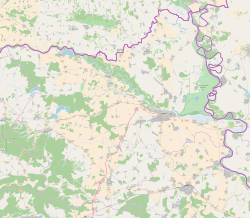
Valpovo is a town in Slavonia, Croatia. It is close to the Drava river, 25 km (16 mi) northwest of Osijek. As of 2021, the population of Valpovo is 7,406, with a total of 11,563 in the municipality. [4]

Contents

Name

In Hungarian the town is known as Valpó [5] and in German as Walpach. [2] In antiquity, it was called Iovalum. [6] There are several suggested etymologies. One is that it comes from the Latin root *Iov-, meaning "divine". However, the ending can't be explained by Latin. One explanation is that it comes from the Indo-European words *yow and *h2elut, so that it means "magical beer." The other, more likely, is that it comes from the Indo-European roots *yow and *h2elom, so that it means "magical herb", whatever plant that signified. Perhaps the simplest explanation is that it comes from the Indo-European word *wel, meaning "valley", whatever "Io-" meant. [7] [ unreliable source? ]

Climate

Since records began in 1964, the highest temperature recorded at the local weather station was 40.4 °C (104.7 °F), on 20 July 2007. [8] The coldest temperature was −25.0 °C (−13.0 °F), on 13 January 2003. [9]

Demographics

The settlements in the municipal area of Valpovo are: [4]

In the census of 2011, the absolute majority [ clarification needed ] were Croats.

Town of Valpovo: Population trends 1857–2021
v
population
6805
7390
7126
8154
8888
9159
8900
9033
8920
9483
10515
11509
12107
12607
12327
11563
9784
18571869188018901900191019211931194819531961197119811991200120112021

History

Valpovo Culture Center Kulturni centar-Valpovo.JPG
Valpovo Culture Center

The town is first mentioned in 1332. [2] In June of 1543, during Sultan Suleiman's campaign into Hungary, Valpovo was besieged, taken, and annexed to the Ottoman Empire. It was initially a kaza centre in the Sanjak of Pojega until 1601. It was later in sanjak centre in Kanije Eyalet until Austrian conquest in 1687.

In the late 19th and early 20th century, Valpovo was part of the Virovitica County of the Kingdom of Croatia-Slavonia. In March 1945, German forces launched Operation Spring Awakening. On the southern arm which moved north through Valpovo was the 1st Cossack Cavalry Division. The operation was as disastrous as it was ambitious. Yugoslav partisans of the 3rd Army (Yugoslav Partisans) continuously harassed and delayed the Cossacks. Shortly after the end of World War II, officials in the communist Yugoslav regime established a labor camp for Germans which operated until May 1946. [2]

Economy

Economy is based on farming, livestock breeding, forestry, wood and timber and foodstuffs industries; close to the town are oil and natural gas deposits. Valpovo lies on a regional road that connects it to Osijek and Donji Miholjac, as well a road to Belišće and to Bizovac through Ladimirevci.

Attractions

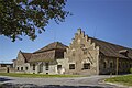
Located close to the banks of the Drava river (5 km), Valpovo was an ancient dwelling of feudal families. Major tourist attraction include important cultural and historical heritage, (remains of a mediaeval fortification, the old brickwork bridge, churches) and a landscaped park, protected as a horticultural monument. Prandau-Normann Castle: Count Normann-Ehrenfels and Baron Prandau-Hilleprandt had a magnificent castle that was rebuilt seven times. They planted 121 herbal sorts on 250,000 square meters. Valpovo's park is one of the most beautiful in Slavonia.

The most important annual event is the Valpovo Summer (Croatian : Ljeto valpovačko), attended by a number of cultural clubs with folklore, music, theatrical and other performances. Angling opportunities are provided on the nearby rivers Karašica, Vučica, Drava, as well as on lakes and fishponds; hunting grounds are offered nearby. Slavonian specialities, venison and freshwater fish, and quality wines add to the visitor opportunities of the Valpovo region.

References

  1. Register of spatial units of the State Geodetic Administration of the Republic of Croatia. Wikidata   Q119585703.
  2. 1 2 3 4 "Valpovo". Croatian Encyclopedia (in Croatian). Miroslav Krleža Institute of Lexicography . Retrieved 23 June 2017.
  3. "Population by Age and Sex, by Settlements" (xlsx). Census of Population, Households and Dwellings in 2021. Zagreb: Croatian Bureau of Statistics. 2022.
  4. 1 2 "Population by Age and Sex, by Settlements, 2011 Census: Valpovo". Census of Population, Households and Dwellings 2011. Zagreb: Croatian Bureau of Statistics. December 2012.
  5. Kocsis, Károly; Kocsis-Hodosi, Eszter (1998). Ethic Geography of the Hungarian Minorities in the Capathian Basin (PDF). Budapest, Hungary: Geographical Research Institute Research Centre For Earth Sciences Hungarian Academy of Sciences. p. 238. ISBN   9637395849.
  6. "Povijest grada Valpova".
  7. "Croatian toponyms - Linguist Forum".
  8. DHMZ (2022-07-19). "Najviše izmjerene temperature zraka u Hrvatskoj za razdoblje od kada postoje mjerenja". Državni hidrometeorološki zavod.
  9. DHMZ (2022-01-21). "Najniže izmjerene temperature zraka u Hrvatskoj za razdoblje od kada postoje mjerenja". Državni hidrometeorološki zavod.

45°40′N18°25′E / 45.667°N 18.417°E / 45.667; 18.417