''Općina Čeminac''"},"settlement_type":{"wt":"[[Municipalities of Croatia|Municipality]]"},"image_skyline":{"wt":"Crkva Presvetog Srca Isusova, Čeminac (2).jpg"},"image_map":{"wt":"CeminacMunicipality.PNG"},"map_caption":{"wt":"Map of Čeminac municipality within the Osijek-Baranja County"},"pushpin_map":{"wt":"Croatia Osijek-Baranja County#Croatia#Europe"},"pushpin_map_caption":{"wt":"Location in Croatia"},"coordinates":{"wt":"{{coord|45|41|11|N|18|40|3|E|region:HR-14|display=inline}}"},"subdivision_type":{"wt":"[[List of sovereign states|Country]]"},"subdivision_name":{"wt":"{{flag|Croatia}}"},"subdivision_type1":{"wt":"[[Regions of Croatia|Region]]"},"subdivision_name1":{"wt":"[[Baranya (region)|Baranya]] ([[Podunavlje]])"},"subdivision_type2":{"wt":"[[Counties of Croatia|County]]"},"subdivision_name2":{"wt":"[[File:Zastava Osječko-baranjske županije.png|border|23px]] [[Osijek-Baranja County|Osijek-Baranja]]"},"leader_title":{"wt":"Mayor"},"leader_name":{"wt":"Damir Rešetar"},"area_footnotes":{"wt":"{{Cite Q|Q119585703|mode=cs1}}"},"area_total_km2":{"wt":"61.4"},"area_urban_km2":{"wt":"22.1"},"population_footnotes":{"wt":"{{Croatian Census 2021|S}}"},"population_as_of":{"wt":"2021"},"population_total":{"wt":"2484"},"population_density_km2":{"wt":"auto"},"population_urban":{"wt":"865"},"population_density_urban_km2":{"wt":"auto"},"timezone":{"wt":"[[Central European Time|CET]]"},"timezone_DST":{"wt":"[[Central European Summer Time|CEST]]"},"utc_offset":{"wt":"+1"},"utc_offset_DST":{"wt":"+2"},"website":{"wt":"{{URL|ceminac.hr}}"}},"i":0}}]}" id="mwBQ">Municipality in Baranya, Croatia
Čeminac | |
---|---|
Municipality of Čeminac Općina Čeminac | |
![]() | |
Map of Čeminac municipality within the Osijek-Baranja County | |
Coordinates: 45°41′11″N18°40′3″E / 45.68639°N 18.66750°E | |
Country | ![]() |
Region | Baranya (Podunavlje) |
County | ![]() |
Government | |
• Mayor | Damir Rešetar |
Area | |
• Municipality | 61.4 km2 (23.7 sq mi) |
• Urban | 22.1 km2 (8.5 sq mi) |
Population (2021) [2] | |
• Municipality | 2,484 |
• Density | 40/km2 (100/sq mi) |
• Urban | 865 |
• Urban density | 39/km2 (100/sq mi) |
Time zone | UTC+1 (CET) |
• Summer (DST) | UTC+2 (CEST) |
Website | ceminac |
Čeminac (Hungarian : Laskafalu, Serbian Cyrillic : Чеминац, German : Laschkafeld) is a village and municipality in Osijek-Baranja County, Croatia. As of 2021, there were 2,856 inhabitants in the municipality. Čeminac is an underdeveloped municipality which is statistically classified as the First Category Area of Special State Concern by the Government of Croatia. [3]
Čeminac is located in the central part of Croatian Baranja and it is surrounded by the municipalities of: Jagodnjak, Beli Manastir, Kneževi Vinogradi, Bilje, and Darda.
The municipality of Čeminac includes the following settlements:
This Village was established by the Danube Swabians (Schwowe) in 1720 from Fulda and Eisfeld, locally also called Stifolder. [4] Colonist settlement of Krčevina was established on the territory of the village municipality during the land reform in interwar Yugoslavia. [5] Čeminac area was home to a sizeable Danube Swabians population before the end of World War II. [6] With the Red Army's crossing of the Danube at Batina most of these Germans left, and their property was confiscated by Communist Yugoslavia's government. [6]
There are 3,500 inhabitants in 1,100 households living in the area of Čeminac. [7]
Ethnic groups in the municipality (2011 census): [8]
Directly elected minority councils and representatives are tasked with consulting the local or regional authorities, advocating for minority rights and interests, integration into public life and participation in the management of local affairs. [9] At the 2023 Croatian national minorities councils and representatives elections Hungarians and Serbs of Croatia each fulfilled legal requirements to elect 10 members municipal minority councils of the Čeminac Municipality but the elections were not held for either one of them due to the lack of candidates. [10]
The coat of arms of Čeminac is Azure a Lion rampant double-queued Or holding a Plough-share Argent. [11]
Osijek-Baranja County is a county in Croatia, located in northeastern Slavonia and Baranja which is defined part of the Pannonian Plain. Its center is Osijek. Other towns include Đakovo, Našice, Valpovo, Belišće, and Beli Manastir.
Beli Manastir is a town in eastern Croatia. It is the principal town of the Croatian part of Baranja, located in the Osijek-Baranja County.
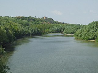
Donji Miholjac, is a town in the Slavonia region of Croatia, on the river Drava and the border with Hungary.
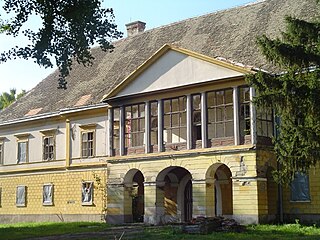
Bilje is a municipality in the Baranja region of Osijek-Baranja County, in north-eastern Croatia. It is 5 km northeast of Osijek, on the edge of the Kopački Rit nature park. Prince Eugene of Savoy (1663-1736) constructed a hunting lodge here, Bilje Castle, which later became property of the Teschen branch of the Habsburg family.
Erdut is a village and a municipality in eastern Croatia some 37 km east of the major city of Osijek. Lying on the border with neighbouring Serbia, it was the site of the signing of the 1995 Erdut Agreement, which initiated the UNTAES transitional administration over the Eastern Slavonia, Baranja and Western Syrmia.
Petlovac is a village and municipality in the western part of Baranja, which comprise the northern part of Osijek-Baranja County in Croatia. Petlovac is underdeveloped municipality which is statistically classified as the First Category Area of Special State Concern by the Government of Croatia.
Darda is a village and a municipality just north of Osijek, Croatia. It is located across the Drava river in Baranja. At the 2011 census, the village population was 5,323, with a total of 6,908 people in the municipality. The castle of the Hungarian Esterhazi family is located in the center of the Darda.
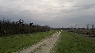
Jagodnjak is a village and a municipality in the Osijek-Baranja County, Croatia. Landscape of the Jagodnjak Municipality is marked by the Drava river with surrounding wetland forest and by Pannonian Basin plains with agricultural fields of wheat, common sunflower, maize and sugar beet.
Šodolovci is a village and a municipality in Osijek-Baranja County in eastern Croatia. In the seven villages of the Šodolovci Municipality, there were 1,653 inhabitants at the time of the 2011 Census.
Čepin is a village and a municipality in Osijek-Baranja County, Croatia. It is located in northeast Slavonia, 10 kilometers southwest of Osijek.
Draž is a village and municipality in Osijek-Baranja County, Croatia. There are 2,767 inhabitants in the municipality.
Ernestinovo is a municipality in Osijek-Baranja County, Croatia.
Koška is a municipality in Osijek-Baranja County, Croatia. There are 3,980 inhabitants, 89.5% of them Croats, 6.78% Serbs and 1.38% Slovaks.
Trnava is a village and a municipality in Osijek-Baranja County, Croatia.
Levanjska Varoš is a municipality in Osijek-Baranja County, Croatia.
Podgorač is a municipality in Osijek-Baranja County, Croatia.
Podravska Moslavina is a village and a municipality in Osijek-Baranja County, Croatia.
Popovac is a village and municipality in Osijek-Baranja County, Croatia. There are 2,084 inhabitants in the municipality. Popovac is an underdeveloped municipality, which is statistically classified as the First Category Area of Special State Concern by the Government of Croatia.
Viljevo is a village and a municipality in Osijek-Baranja County, Croatia.
Vladislavci is a village and a municipality in Osijek-Baranja County, Croatia.