
Project Plowshare was the overall United States program for the development of techniques to use nuclear explosives for peaceful construction purposes. As part of the program, 31 nuclear warheads were detonated in 27 separate tests. Plowshare was the US portion of what are called Peaceful Nuclear Explosions (PNE); a similar Soviet program was carried out under the name Nuclear Explosions for the National Economy.
Nuclear weapons tests are experiments carried out to determine nuclear weapons' effectiveness, yield, and explosive capability. Testing nuclear weapons offers practical information about how the weapons function, how detonations are affected by different conditions, and how personnel, structures, and equipment are affected when subjected to nuclear explosions. However, nuclear testing has often been used as an indicator of scientific and military strength. Many tests have been overtly political in their intention; most nuclear weapons states publicly declared their nuclear status through a nuclear test.
The Sand Springs Range is a short mountain range located in western Nevada in the United States within the Great Basin. It is approximately 10 miles (16 km) long and is in Churchill County. It separates Salt Wells from Fairview Valley. To the north, it is separated from the Stillwater Range by Sand Springs Pass. To the south is Gabbs Valley.
Project Vela was a project undertaken by the United States Department of Defense to develop and implement methods to monitor compliance with the 1963 Partial Test Ban Treaty. This treaty banned the testing of nuclear weapons in the atmosphere, in outer space, and underwater, effectively meaning nuclear tests were only to be permitted underground.

Amchitka is a volcanic, tectonically unstable island in the Rat Islands group of the Aleutian Islands in southwest Alaska. It is part of the Alaska Maritime National Wildlife Refuge. The island, with a land area of roughly 116 square miles (300 km2), is about 42 miles (68 km) long and 1 to 4 miles wide. The area has a maritime climate, with many storms, and mostly overcast skies.
Induced seismicity refers to typically minor earthquakes and tremors that are caused by human activity that alters the stresses and strains on Earth's crust. Most induced seismicity is of a low magnitude. A few sites regularly have larger quakes, such as The Geysers geothermal plant in California which averaged two M4 events and 15 M3 events every year from 2004 to 2009. The Human-Induced Earthquake Database (HiQuake) documents all reported cases of induced seismicity proposed on scientific grounds and is the most complete compilation of its kind.

The Vela incident, also known as the South Atlantic Flash, was an unidentified double flash of light detected by an American Vela Hotel satellite on 22 September 1979 near the Prince Edward Islands in the Indian Ocean.

Earthquake engineering is an interdisciplinary branch of engineering that designs and analyzes structures, such as buildings and bridges, with earthquakes in mind. Its overall goal is to make such structures more resistant to earthquakes. An earthquake engineer aims to construct structures that will not be damaged in minor shaking and will avoid serious damage or collapse in a major earthquake. Earthquake engineering is the scientific field concerned with protecting society, the natural environment, and the man-made environment from earthquakes by limiting the seismic risk to socio-economically acceptable levels. Traditionally, it has been narrowly defined as the study of the behavior of structures and geo-structures subject to seismic loading; it is considered as a subset of structural engineering, geotechnical engineering, mechanical engineering, chemical engineering, applied physics, etc. However, the tremendous costs experienced in recent earthquakes have led to an expansion of its scope to encompass disciplines from the wider field of civil engineering, mechanical engineering, nuclear engineering, and from the social sciences, especially sociology, political science, economics, and finance.
Nuclear Explosions for the National Economy was a Soviet program to investigate peaceful nuclear explosions (PNEs). It was analogous to the United States program Operation Plowshare.

The Air Force Technical Applications Center (AFTAC), based at Patrick Space Force Base, Florida is an Air Force surveillance organization assigned to the Sixteenth Air Force. Its mission is to monitor nuclear treaties of all applicable signatory countries. This is accomplished via seismic, hydroacoustic and satellite detection systems.

Underground nuclear testing is the test detonation of nuclear weapons that is performed underground. When the device being tested is buried at sufficient depth, the nuclear explosion may be contained, with no release of radioactive materials to the atmosphere.

Project Gnome was the first nuclear test of Project Plowshare and was the first continental nuclear weapon test since Trinity to be conducted outside of the Nevada Test Site. It was tested in southeastern New Mexico, approximately 40 km southeast of Carlsbad, New Mexico.
National technical means of verification (NTM) are monitoring techniques, such as satellite photography, used to verify adherence to international treaties. The phrase first appeared, but was not detailed, in the Strategic Arms Limitation Treaty (SALT) between the US and USSR. At first, the phrase reflected a concern that the "Soviet Union could be particularly disturbed by public recognition of this capability [satellite photography]...which it has veiled.". In modern usage, the term covers a variety of monitoring technologies, including others used at the time of SALT I.

Salmon Site is a 1,470-acre (5.9 km2) tract of land in Lamar County, Mississippi, near Baxterville. The tract is located over a geological formation known as the Tatum Salt Dome and is the location of the only nuclear weapons test detonations known to have been performed in the eastern United States.
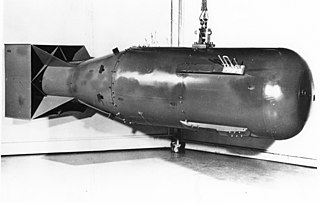
Cannikin was an underground nuclear weapons test performed on November 6, 1971, on Amchitka island, Alaska, by the United States Atomic Energy Commission. The experiment, part of the Operation Grommet nuclear test series, tested the unique W71 warhead design for the LIM-49 Spartan anti-ballistic missile. With an explosive yield of almost 5 megatons of TNT (21 PJ), the test was the largest underground explosion ever detonated by the United States.
A tectonic weapon is a hypothetical device or system which could create earthquakes, volcanoes, or other seismic events in specified locations by interfering with the Earth's natural geological processes. It was defined in 1992 by Aleksey Vsevolodovich Nikolayev, corresponding member Russian Academy of Sciences: "A tectonic or seismic weapon would be the use of the accumulated tectonic energy of the Earth's deeper layers to induce a destructive earthquake". He added "to set oneself the objective of inducing an earthquake is extremely doubtful".

Project Shoal was an underground nuclear test that took place on October 26, 1963 within the Sand Springs Range, approximately 30 miles (48 km) southeast of Fallon, Nevada, in a granite formation of the range. The site was selected because its earthquake activity afforded a basis for seismic signal comparisons.

On 12 February 2013, North Korean state media announced it had conducted an underground nuclear test, its third in seven years. A tremor that exhibited a nuclear bomb signature with an initial magnitude 4.9 was detected by the China Earthquake Networks Center, Preparatory Commission for the Comprehensive Nuclear-Test-Ban Treaty Organization and the United States Geological Survey. In response, Japan summoned an emergency United Nations meeting for 12 February and South Korea raised its military alert status. It is not known whether the explosion was nuclear or a conventional explosion designed to mimic a nuclear blast; as of two days after the blast, Chinese, Japanese, and South Korean investigators had failed to detect any radiation.
A nuclear detonation detection system (NDDS) is a device or a series of devices that are able to indicate, and pinpoint a nuclear explosion has occurred as well as the direction of the explosion. The main purpose of these devices or systems was to verify compliance of countries that signed nuclear treaties such as the Partial Test Ban treaty of 1963 (PTBT) and the Treaty of Tlatelolco.
The World-Wide Standardized Seismograph Network (WWSSN) – originally the World-Wide Network of Seismograph Stations (WWNSS) – was a global network of about 120 seismograph stations built in the 1960s that generated an unprecedented collection of high quality seismic data. This data enabled seismology to become a quantitative science, elucidated the focal mechanisms of earthquakes and the structure of the earth's crust, and contributed to the development of plate tectonic theory. The WWSSN is credited with spurring a renaissance in seismological research.