Victoria (District Electoral Area) Last updated August 04, 2025 Electoral division in east Belfast, Northern Ireland
Human settlement in Northern Ireland
Victoria was one of the nine district electoral areas (DEA) in Belfast , Northern Ireland , from 1985 to 2014, when it was mostly replaced by the Ormiston district. [ 1]
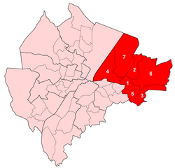
Located in the east of the city, the district elected seven members to Belfast City Council and contained the wards of Ballyhackamore ; Belmont; Cherryvalley ; Island; Knock; Stormont; and Sydenham. Victoria, along with wards from the neighbouring Pottinger district and Castlereagh Borough Council , formed the Belfast East constituency for the Northern Ireland Assembly and UK Parliament .
The district was bounded to the west by the Victoria Channel, to the north by Belfast Lough , to the northeast by North Down Borough Council , to the south and east by Castlereagh Borough Council and to the southwest by the Newtownards Road.
At each election throughout the district's existence, most of the councillors elected were Unionist .
History The DEA was created for the 1985 local elections as the successor to the former Area B , which all seven wards in the new Victoria had been part of. An eighth ward, Bloomfield, which had been in Area B, was placed in the new Pottinger electoral area . It was abolished in 2015, making way for the new DEAs that were used for the 2014 local elections. It was largely replaced by the new Ormiston District Electoral Area . Five of Victoria's wards joined Ormiston, with the Sydenham ward and the areas which had been part of the abolished Island ward becoming part of the new Titanic District Electoral Area . [ 2]
The district contained many key pieces of Belfast's transport infrastructure, including George Best Belfast City Airport and the eastern portion of Belfast Harbour . The area is served by the Bridge End and Sydenham railway stations and the A2 and A20 major road routes. The district is also home to Parliament Buildings , the meeting place of the Northern Ireland Assembly .
Victoria was once the site of much of Belfast's heavy industrial manufacturing facilities, however these have suffered a significant decline since the mid-twentieth century, although companies such as Short Brothers and Harland and Wolff continue to have significant operations in the area.
Wards Parliament Buildings , Stormont Map Ward Population (2011 Census) Catholic Protestant Other No Religion Area Density NI Assembly UK Parliament Ref 1 Ballyhackamore 5,939 17.2% 68.2% 1.9% 12.7% 1.15 km2 5,164 /km2 Belfast East Belfast East [ 3] 2 Belmont 6,165 8.6% 80.6% 1% 9.8% 1.79 km2 3,444 /km2 Belfast East Belfast East [ 4] 3 Cherryvalley 5,920 14.5% 75.3% 0.8% 9.4% 1.99 km2 2,975 /km2 Belfast East Belfast East [ 5] 4 Island 5,014 13.9% 69.8% 4.6% 11.8% 3.81 km2 1,316 /km2 Belfast East Belfast East [ 6] 5 Knock 4,827 9.1% 79.7% 1.2% 10% 1.12 km2 4,310 /km2 Belfast East Belfast East [ 7] 6 Stormont 5,548 12.9% 75.6% 1.3% 10.2% 7.04 km2 788 /km2 Belfast East Belfast East [ 8] 7 Sydenham 4,874 9.9% 76% 1.8% 12.3% 6.24 km2 781 /km2 Belfast East Belfast East [ 9] Victoria 38,287 12.4% 75% 1.7% 10.8% 23.14 km2 1,655 /km2
2011 Election 2005: 3 x DUP, 2 x UUP, 2 x Alliance
2011: 3 x Alliance, 3 x DUP, 1 x UUP
2005-2011 Change: Alliance gain from UUP
Victoria - 7 seats [ 10] Party Candidate FPv% Count 1 2 3 4 5 6 7 8 9 10 DUP Robin Newton *16.62% 2,338 Alliance Mervyn Jones *16.49% 2,319 Alliance Laura McNamee 11.92% 1,677 1,686.5 2,049.14 Alliance Andrew Webb 8.08% 1,137 1,143 1,293.48 1,541.24 1,552.24 1,592.1 1,604.1 1,895.1 UUP Jim Rodgers *9.63% 1,355 1,401.5 1,407.98 1,418.81 1,437.81 1,451.62 1,488.87 1,639.24 1,657.24 1,816.24 DUP Tom Haire 10.22% 1,437 1,555.5 1,558.62 1,562.04 1,565.04 1,568.53 1,584.97 1,617.21 1,622.21 1,759.21 DUP John Hussey 5.77% 812 1,149 1,151.64 1,154.11 1,158.11 1,166.36 1,184.86 1,210.54 1,217.54 1,476.12 UUP Ian Adamson * 6.70% 942 955.25 962.69 967.25 989.5 1,003.69 1,028.19 1,112.99 1,131.9 1,228.49 PUP Robert McCartney 6.46% 908 926.75 930.59 932.68 938.68 946.87 963.37 1,005.54 1,028.54 Green (NI) Ross Campbell 2.24% 315 317.25 322.53 325.95 334.14 353.14 359.14 UUP Stephen Warke 1.54% 216 222.5 224.42 226.32 232.51 237.51 246.51 SDLP Magdalena Wolska 1.47% 207 207.5 211.58 215.76 217.76 222 223 TUV Sammy Morrison 1.12% 158 160.25 160.25 161.01 162.01 175.01 Independent Roy Hobson 1.01% 142 143.75 145.43 147.14 158.39 NI Conservatives Garry Crosbie 0.73% 103 103.5 103.5 104.07 Electorate: 25,814 Valid: 14,066 (54.49%) Spoilt: 280 Quota: 1,759 Turnout: 14,346 (55.57%)
2005 Election 2001: 3 x UUP, 2 x DUP, 2 x Alliance
2005: 3 x DUP, 2 x UUP, 2 x Alliance
2001-2005 Change: DUP gain from UUP
Victoria - 7 seats [ 11] Party Candidate FPv% Count 1 2 3 4 5 6 7 DUP Wallace Browne *18.60% 2,689 Alliance Naomi Long *17.74% 2,565 UUP Jim Rodgers *16.88% 2,441 DUP Robin Newton *13.86% 2,004 UUP Ian Adamson *12.98% 1,877 DUP David Rodway 5.01% 725 1,527.4 1,549.72 1,635.12 1,810.52 Alliance Mervyn Jones 5.61% 811 815.42 1,421.47 1,456.75 1,458.85 1,461.82 1,838.82 UUP Alan Crowe* 3.17% 459 508.98 582.76 1,041.76 1,050.86 1,099.16 1,366.16 SDLP John Ó Doherty 2.35% 340 343.4 374.09 379.69 379.99 380.14 PUP John McQuillan 2.10% 303 310.82 321.36 337.88 340.38 340.89 NI Conservatives Peter Gray 1.68% 243 252.52 265.23 287.35 288.45 289.53 Electorate: 25,058 Valid: 14,457 (57.69%) Spoilt: 349 Quota: 1,808 Turnout: 14,806 (59.09%)
2001 Election 1997: 2 x UUP, 2 x Alliance, 2 x DUP, 1 x Independent Unionist
2001: 3 x UUP, 2 x DUP, 2 x Alliance
1997-2001 Change: Independent Unionist joins UUP
Victoria - 7 seats [ 12] Party Candidate FPv% Count 1 2 3 4 5 6 7 8 9 UUP Ian Adamson *19.43% 3,286 Alliance David Alderdice *18.45% 3,119 DUP Wallace Browne *14.74% 2,492 UUP Jim Rodgers *13.73% 2,322 UUP Alan Crowe *3.44% 582 1,569.16 1,716.04 1,727.89 1,858.75 1,881.65 2,011.63 2,194.63 Alliance Naomi Long 4.31% 729 776.36 1,399.58 1,401.23 1,407.62 1,416.83 1,702.74 1,792.2 2,017.89 DUP Robin Newton *8.69% 1,469 1,492.31 1,516.45 1,636 1,658.41 1,678.71 1,702.85 1,810.58 1,955.77 DUP Margaret McKenzie 4.63% 783 811.12 826.76 1,045.16 1,059.29 1,076.49 1,111.65 1,226.47 1,426.49 Independent Danny Dow* 4.41% 746 758.58 816.04 823.39 830.77 857.54 890.67 996.7 PUP Robert Moorhead 4.12% 697 715.87 736.27 739.87 745.72 761.15 795.85 SDLP Ciara Farren 1.80% 305 310.18 383.62 383.77 384.76 390.78 NI Conservatives Peter Gray 1.41% 239 261.57 284.35 286.45 291.76 301.92 Independent Sammy Walker 0.67% 114 123.25 130.39 130.39 133.36 Independent Billy Hands 0.09% 15 16.48 17.84 17.84 18.02 Independent Lawrence John 0.06% 11 12.11 14.15 14.15 14.24 Electorate: 28,160 Valid: 17,468 (62.03%) Spoilt: 559 Quota: 2,114 Turnout: 16,909 (60.05%)
1997 Election 1993: 3 x UUP, 2 x Alliance, 2 x DUP
1997: 2 x UUP, 2 x Alliance, 2 x DUP, 1 x Independent Unionist
1993-1997 Change: Independent Unionist gain from UUP
Victoria - 7 seats [ 13] Party Candidate FPv% Count 1 2 3 4 5 6 7 8 9 Alliance David Alderdice 18.87% 2,419 UUP Ian Adamson *18.46% 2,367 Alliance Danny Dow *7.99% 1,024 1,609.14 UUP Jim Rodgers *11.76% 1,508 1,532.14 1,921.58 DUP Wallace Browne *11.58% 1,485 1,498.94 1,564.54 1,569.22 1,590.52 1,747.52 DUP Robin Newton *8.08% 1,036 1,044.5 1,052.82 1,055.94 1,070.52 1,336.04 1,477.94 1,522.22 1,658.22 Ind. Unionist Alan Crowe 4.05% 519 544.16 710.24 736.5 803.68 831.18 1,023.4 1,237.5 1,242.5 PUP John McQuillan 7.14% 915 924.86 937.98 940.32 956.96 1,001.88 1,040.16 1,149.92 1,151.92 Alliance Glyn Roberts 4.31% 553 675.74 698.78 702.94 761.48 771.26 842.62 UUP Peter Weir 1.50% 192 196.76 245.72 509.88 569.64 582.76 DUP Margaret McKenzie 4.08% 523 524.36 533 535.08 558.74 NI Conservatives Lesley Donaldson 2.00% 256 270.96 293.04 295.9 Natural Law Thomas Mullins 0.19% 25 27.38 27.7 27.96 Electorate: 28,936 Valid: 12,822 (44.31%) Spoilt: 351 Quota: 1,603 Turnout: 13,173 (45.52%)
1993 Election 1989: 3 x UUP, 2 x Alliance, 2 x DUP
1993: 3 x UUP, 2 x Alliance, 2 x DUP
1989-1993 Change: No change
Victoria - 7 seats [ 14] Party Candidate FPv% Count 1 2 3 4 5 6 7 8 9 Alliance John Alderdice *24.67% 3,337 DUP Wallace Browne *15.92% 2,153 UUP Thomas Patton *13.31% 1,801 DUP Robin Newton *12.78% 1,729 UUP Ian Adamson *9.73% 1,316 1,395.56 1,547.81 1,564.23 1,686.5 1,880.5 Alliance Danny Dow *4.08% 552 1,543.44 1,564.9 1,642.89 1,661.29 1,761.29 UUP Jim Rodgers 4.44% 600 631.62 749.07 757.18 1,091.36 1,274.11 1,408.11 1,560.65 1,510.25 Alliance Maureen McConnell 5.68% 768 1,159.68 1,169.54 1,220.19 1,226.21 1,368.9 1,387.9 1,393.92 1,454.4 NI Conservatives Jim McCormick 5.06% 684 759.99 784.93 807.3 828.13 UUP John Norris 3.01% 407 435.56 554.17 561.97 Green (NI) Michael Bell 1.33% 180 218.76 225.72 Electorate: 29,632 Valid: 13,527 (45.65%) Spoilt: 360 Quota: 1,691 Turnout: 13,887 (46.86%)
1989 Election 1985: 3 x UUP, 2 x Alliance, 2 x DUP
1989: 3 x UUP, 2 x Alliance, 2 x DUP
1985-1989 Change: No change
Victoria - 7 seats [ 15] Party Candidate FPv% Count 1 2 3 4 5 6 Alliance John Alderdice 21.67% 2,933 UUP Thomas Patton *21.02% 2,845 UUP Ian Adamson 12.78% 1,730 DUP Wallace Browne *10.15% 1,374 1,407.97 1,512.97 1,523.34 1,585.51 1,890.51 DUP Robin Newton *8.65% 1,171 1,177.88 1,274.06 1,287.33 1,346.33 1,644.33 Alliance Danny Dow 5.41% 732 1,405.38 1,475.94 1,617.36 1,685.17 1,696.17 UUP Alan Montgomery 5.67% 767 821.61 1,496.55 1,521.91 1,641.98 1,692.98 Alliance George Thompson* 3.94% 533 937.2 963.66 1,041.39 1,110.23 1,117.23 DUP Irene Lewis 4.93% 667 685.49 776.63 786.05 846.22 Ind. Unionist Samuel Walker 3.32% 449 469.64 520.46 555.74 Workers' Party Hugh Jordan 2.46% 333 359.23 378.97 Electorate: 30,508 Valid: 13,534 (44.36%) Spoilt: 367 Quota: 1,692 Turnout: 13,901 (45.57%)
1985 Election 1985: 3 x UUP, 2 x DUP, 2 x Alliance
Victoria - 7 seats [ 16] Party Candidate FPv% Count 1 2 3 4 5 6 7 DUP Wallace Browne 22.22% 3,447 UUP Thomas Patton *15.41% 2,390 Alliance Oliver Napier *14.89% 2,309 UUP William Corry *11.85% 1,838 1,985.4 UUP Dorothy Dunlop 8.80% 1,365 1,425.28 1,595.14 1,596.58 1,619.62 2,282.62 Alliance George Thompson 8.23% 1,278 1,289.88 1,312.68 1,457.68 1,775.92 1,844.14 1,918.01 DUP Robin Newton 3.64% 564 1,611.64 1,636.15 1,640.03 1,644.03 1,772.26 1,910.87 DUP Samuel Walker 7.29% 1,131 1,330.76 1,400.49 1,401.68 1,408.72 1,579.34 1,708.82 UUP John McCrea 6.46% 1,002 1,033.68 1,175.61 1,176.61 1,186.53 SDLP Barry Gilheany 1.21% 188 189.76 190.33 Electorate: 30,776 Valid: 15,512 (50.40%) Spoilt: 427 Quota: 1,940 Turnout: 15,939 (51.79%)
References
Places adjacent to Victoria (District Electoral Area)
This page is based on this
Wikipedia article Text is available under the
CC BY-SA 4.0 license; additional terms may apply.
Images, videos and audio are available under their respective licenses.