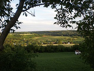
Vindornyaszőlős

Last updated

Vindornyaszőlős
Village
CountryFlag of Hungary.svg  Hungary
Region Western Transdanubia
County Zala County
Time zone CET (UTC+1)
  Summer (DST) CEST (UTC+2)

Vindornyaszőlős is a village in Zala County, Hungary. [1]

Zala County Counties of Hungary in Western Transdanubia

Zala is an administrative county in south-western Hungary. It is named after the Zala River. It shares borders with Croatia and Slovenia and the Hungarian counties Vas, Veszprém and Somogy. The capital of Zala county is Zalaegerszeg. Its area is 3,784 square kilometres (1,461 sq mi). Lake Balaton lies partly in the county.
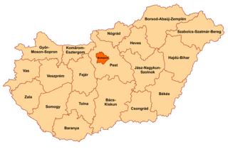
Counties of Hungary counties of Hungary since 1950

Hungary is subdivided administratively into 19 counties and the capital city (főváros) Budapest. The counties are further subdivided into 174 districts. The capital Budapest is subdivided into 23 districts.

Hungary Country in Central Europe

Hungary is a country in Central Europe. Spanning 93,030 square kilometres (35,920 sq mi) in the Carpathian Basin, it borders Slovakia to the north, Ukraine to the northeast, Austria to the northwest, Romania to the east, Serbia to the south, Croatia to the southwest, and Slovenia to the west. With about 10 million inhabitants, Hungary is a medium-sized member state of the European Union. The official language is Hungarian, which is the most widely spoken Uralic language in the world, and among the few non-Indo-European languages to be widely spoken in Europe. Hungary's capital and largest city is Budapest; other major urban areas include Debrecen, Szeged, Miskolc, Pécs and Győr.

Related Research Articles

Fejér County Counties of Hungary in Central Transdanubia

Fejér is an administrative county in Central Hungary. It lies on the west bank of the river Danube and nearly touches the eastern shore of Lake Balaton. It shares borders with the Hungarian counties Veszprém, Komárom-Esztergom, Pest, Bács-Kiskun, Tolna and Somogy. The capital of Fejér county is Székesfehérvár.

Somogy County Counties of Hungary in Southern Transdanubia

Somogy is an administrative county in present Hungary, and also in the former Kingdom of Hungary.

Cetatea de Baltă Commune in Alba County, Romania

Cetatea de Baltă is a commune in Alba County, Romania. It is located between Târnăveni at 15 kilometers and Blaj at 21 kilometers on the county road DJ 117. The commune is composed of four villages: Cetatea de Baltă, Crăciunelu de Sus, Sântămărie and Tătârlaua.

Sot (village) Village in Vojvodina, Serbia

Sot is a village located in Syrmia, Vojvodina, Serbia. It is situated in the Šid municipality, in the Syrmia District. The village is ethnically mixed and its population numbering 791 people.

Mýtne Ludany municipality of Slovakia

Mýtne Ludany is a village and municipality in the Levice District in the Nitra Region of Slovakia.

Tataháza Place in Bács-Kiskun, Hungary

Tataháza is a village in Bács-Kiskun county, in the Southern Great Plain region of southern Hungary.

Nagybánhegyes Place in Békés, Hungary

Nagybánhegyes is a village in Békés County, in the Southern Great Plain region of south-east Hungary.

Okány Place in Békés, Hungary

Okány is a village in Békés County, in the Southern Great Plain region of south-east Hungary.

Tiszasziget Place in Csongrád, Hungary

Tiszasziget is a village in Csongrád county, in the Southern Great Plain region of southern Hungary.

Apátfalva Place in Csongrád, Hungary

Apátfalva is a village in Csongrád County, in the Southern Great Plain region of southern Hungary.

Nyírderzs Place in Szabolcs-Szatmár-Bereg, Hungary

Nyírderzs is a village in Szabolcs-Szatmár-Bereg county, in the Northern Great Plain region of eastern Hungary.

Brateiu Commune in Sibiu County, Romania

Brateiu is a commune located in Sibiu County, Romania. It is composed of two villages, Brateiu and Buzd, each of which has a fortified church. There is a burial ground located here which is dated to the 4th century. The Daco-Roman cemetery is situated on the bank of the Tirnava Mare river, and is estimated to date to between 380 - 454 AD.

Deda, Mureș Commune in Mureș County, Romania

Deda is a commune in Mureș County, Transylvania, Romania. It is composed of four villages: Bistra Mureşului (Dédabisztra), Deda, Filea (Füleháza) and Pietriş (Maroskövesd).

Börzönce is a village in Zala County, Hungary.

Felsőpáhok is a village in Zala County, Hungary.

Hagyárosbörönd is a village in Zala County, Hungary.

Kisgörbő is a village in Zala County, Hungary.

Sénye is a village in Zala County, Hungary.

Zalaszentiván Village in Western Transdanubia, Hungary

Zalaszentiván is a village in Zala County, Hungary.

Békéscsaba District Districts of Hungary in Békés

Békéscsaba is a district in central-southern part of Békés County. Békéscsaba is also the name of the town where the district seat is found. The district is located in the Southern Great Plain Statistical Region.

References

Coordinates: 46°54′N17°10′E / 46.900°N 17.167°E / 46.900; 17.167

Geographic coordinate system Coordinate system

A geographic coordinate system is a coordinate system that enables every location on Earth to be specified by a set of numbers, letters or symbols. The coordinates are often chosen such that one of the numbers represents a vertical position and two or three of the numbers represent a horizontal position; alternatively, a geographic position may be expressed in a combined three-dimensional Cartesian vector. A common choice of coordinates is latitude, longitude and elevation. To specify a location on a plane requires a map projection.