Zvenigovo is a town and the administrative center of Zvenigovsky District of the Mari El Republic, Russia, located on the left bank of the Volga River, 90 kilometers (56 mi) south of Yoshkar-Ola, the capital of the republic. As of the 2010 Census, its population was 11,946.
Sovetsky is an urban locality and the administrative center of Sovetsky District of the Mari El Republic, Russia. As of the 2010 Census, its population was 10,664.
Kilemarsky District is an administrative and municipal district (raion), one of the fourteen in the Mari El Republic, Russia. It is located in the west of the republic. The area of the district is 3,255 square kilometers (1,257 sq mi). Its administrative center is the urban locality of Kilemary. As of the 2010 Census, the total population of the district was 13,604, with the population of Kilemary accounting for 29.9% of that number.

Mari-Tureksky District is an administrative and municipal district (raion), one of the fourteen in the Mari El Republic, Russia. It is located in the east of the republic. The area of the district is 1,500 square kilometers (580 sq mi). Its administrative center is the urban locality of Mari-Turek. As of the 2010 Census, the total population of the district was 23,155, with the population of Mari-Turek accounting for 22.3% of that number.

Novotoryalsky District is an administrative and municipal district (raion), one of the fourteen in the Mari El Republic, Russia. It is located in the northeast of the republic. The area of the district is 920 square kilometers (360 sq mi). Its administrative center is the urban locality of Novy Toryal. As of the 2010 Census, the total population of the district was 17,124, with the population of Novy Toryal accounting for 38.7% of that number.
Paranginsky District is an administrative and municipal district (raion), one of the fourteen in the Mari El Republic, Russia. It is located in the east of the republic. The area of the district is 800 square kilometers (310 sq mi). Its administrative center is the urban locality of Paranga. As of the 2010 Census, the total population of the district was 16,307, with the population of Paranga accounting for 36.7% of that number.

Sernursky District is an administrative and municipal district (raion), one of the fourteen in the Mari El Republic, Russia. It is located in the northeast of the republic. The area of the district is 1,032 square kilometers (398 sq mi). Its administrative center is the urban locality of Sernur. As of the 2010 Census, the total population of the district was 25,672, with the population of Sernur accounting for 33.8% of that number.

Volzhsky District is an administrative and municipal district (raion), one of the fourteen in the Mari El Republic, Russia. It is located in the south of the republic. The area of the district is 942.7 square kilometers (364.0 sq mi). Its administrative center is the town of Volzhsk. As of the 2010 Census, the total population of the district was 23,940.
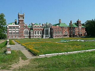
Yurinsky District is an administrative and municipal district (raion), one of the fourteen in the Mari El Republic, Russia. It is located in the west of the republic. The area of the district is 2,040 square kilometers (790 sq mi). Its administrative center is the urban locality of Yurino. As of the 2010 Census, the total population of the district was 8,758, with the population of Yurino accounting for 39.6% of that number.

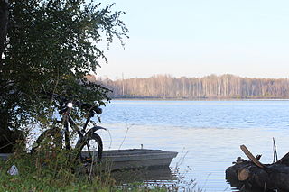
Zvenigovsky District is an administrative and municipal district (raion), one of the fourteen in the Mari El Republic, Russia. It is located in the south of the republic. The area of the district is 2,748 square kilometers (1,061 sq mi). Its administrative center is the town of Zvenigovo. As of the 2010 Census, the total population of the district was 44,976, with the population of Zvenigovo accounting for 26.6% of that number.
Medvedevo is an urban locality and the administrative center of Medvedevsky District of the Mari El Republic, Russia. As of the 2010 Census, its population was 16,841.
Yurino is an urban locality and the administrative center of Yurinsky District of the Mari El Republic, Russia, located on the Cheboksary Reservoir, near the confluence of the Volga and Vetluga Rivers. As of the 2010 Census, its population was 3,465.
Kilemary is an urban locality and the administrative center of Kilemarsky District of the Mari El Republic, Russia. As of the 2010 Census, its population was 4,073.
Kuzhener is an urban locality and the administrative center of Kuzhenersky District of the Mari El Republic, Russia. As of the 2010 Census, its population was 5,384.
Mari-Turek is an urban locality and the administrative center of Mari-Tureksky District of the Mari El Republic, Russia. As of the 2010 Census, its population was 5,164.
Morki is an urban locality and the administrative center of Morkinsky District of the Mari El Republic, Russia. As of the 2010 Census, its population was 9,914.
Orshanka is an urban locality and the administrative center of Orshansky District of the Mari El Republic, Russia. As of the 2010 Census, its population was 6,589.

Paranga is an urban locality and the administrative center of Paranginsky District of the Mari El Republic, Russia. As of the 2010 Census, its population was 5,985.

Krasnogorsky is an urban locality in Zvenigovsky District of the Mari El Republic, Russia. As of the 2010 Census, its population was 6,699.
Suslonger is an urban locality in Zvenigovsky District of the Mari El Republic, Russia. As of the 2010 Census, its population was 3,161.


