Jászszentlászló is a village in Bács-Kiskun county, in the Southern Great Plain region of southern Hungary. It lies just south of Kiskunfélegyháza and just north of Kiskunmajsa. The town is a stop on the railroad line between Kecskemét and Baja.

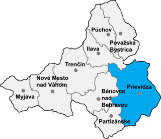
Opatovce nad Nitrou is a village and municipality in Prievidza District in the Trenčín Region of western Slovakia.
Mecklenburgische Schweiz is an Amt in the district of Rostock, in Mecklenburg-Vorpommern, Germany. The seat of the Amt is in Teterow, itself not part of the Amt.

Solovăstru is a commune in Mureș County, Romania that is composed of two villages, Jabenița (Görgénysóakna) and Solovăstru. It has a population of 2,847: 94% Romanians, 5% Romani and 1% Hungarians.

Ortaoba is a village in the Khachmaz Rayon of Azerbaijan. The village forms part of the municipality of Yalama.

Budy Krępskie is a village in the administrative district of Gmina Łaskarzew, within Garwolin County, Masovian Voivodeship, in east-central Poland. It lies approximately 4 kilometres (2 mi) south-west of Łaskarzew, 16 km (10 mi) south of Garwolin, and 64 km (40 mi) south-east of Warsaw.
Becsvölgye is a village in Zala County, Hungary.
Bókaháza is a village in Zala County, Hungary.
Kálócfa is a village in Zala County, Hungary.
Kányavár is a village in Zala County, Hungary.
Kerkabarabás is a village in Zala County, Hungary.
Lickóvadamos is a village in Zala County, Hungary.
Lovászi is a village in Zala County, Hungary.

Szécsisziget is a village in Zala County, Hungary.
Szentpéterfölde is a village in Zala County, Hungary.
Szentpéterúr is a village in Zala County, Hungary.
Zalatárnok is a village in Zala County, Hungary.
Krustets is a village in Tryavna Municipality, in Gabrovo Province, in northern central Bulgaria.
Metsaküla is a village in Türi Parish, Järva County in central Estonia.
Kivijärve is a village in Jõgeva Parish, Jõgeva County in eastern Estonia.


